

UPDATES: TS Flossie Moving WNW; TS Gil Forms in Eastern N. Pacific
 BIG ISLAND CLOSURE, CANCELLATION, NOTICE UPDATES
BIG ISLAND POWER OUTAGE UPDATES
BIG ISLAND TRAFFIC & ROAD UPDATES
SANDBAGGING TIPS & SOURCES • PET SAFETY TIPS
The next advisory will be issued at 11 PM.
Saturday, Aug. 3, 2019
5 PM: FLOSSIE GRADUALLY WEAKENING
-

- TS Flossie, 5 PM, Aug. 3, 2019. PC: NOAA

-

- TS Flossie, 5 PM, Aug. 3, 2019. PC: NOAA
-

- TS Flossie, 5 PM, Aug. 3, 2019. PC: NOAA

-

- TS Flossie, 5 PM, Aug. 3, 2019. PC: NOAA

-

- TS Flossie, 5 PM, Aug. 3, 2019. PC: NOAA


The center of Tropical Storm Flossie is located near latitude 18.9°N, longitude 145.6°W, about 620 miles east of Hilo.
Flossie is moving toward the west near 13 mph and a continued motion toward the west to WNW is expected during the next couple of days.
Maximum sustained winds are near 45 mph with higher gusts.
Weakening is forecast during the next 48 hours and Flossie is expected to become a tropical depression Sunday night.
Tropical-storm-force winds extend outward up to 90 miles from the center.
The estimated minimum central pressure is 29.68 inches.
HAZARDS AFFECTING LAND
SURF: Swells generated by Flossie will affect portions of the main Hawaiian Islands over the next couple of days, potentially producing dangerous surf conditions, mainly along east- and SE-facing shores.
5 PM: GIL MOVING WESTWARD WITH LITTLE CHANGE IN STRENGTH

TS Gil, 5 PM, Aug. 3, 2019. PC: NOAA
The center of Tropical Storm Gil is located near latitude 14.9°N, longitude 123.6°W.
Gil is moving toward the west near 12 mph. A generally westward motion at about the same forward speed is forecast for the next couple of days.
Maximum sustained winds remain near 40 mph, with higher gusts. A gradual weakening trend is expected to begin by late Sunday, and Gil is expected to dissipate by Tuesday.
Tropical-storm-force winds extend outward up to 80 miles from the center.
The estimated minimum central pressure is 29.71 inches.
3:36 PM: HIGH SURF WARNING IN EFFECT UNTIL 6 AM MONDAY DUE TO TROPICAL STORM FLOSSIE
The National Weather Service in Honolulu has CANCELLED the Small Craft Advisory.
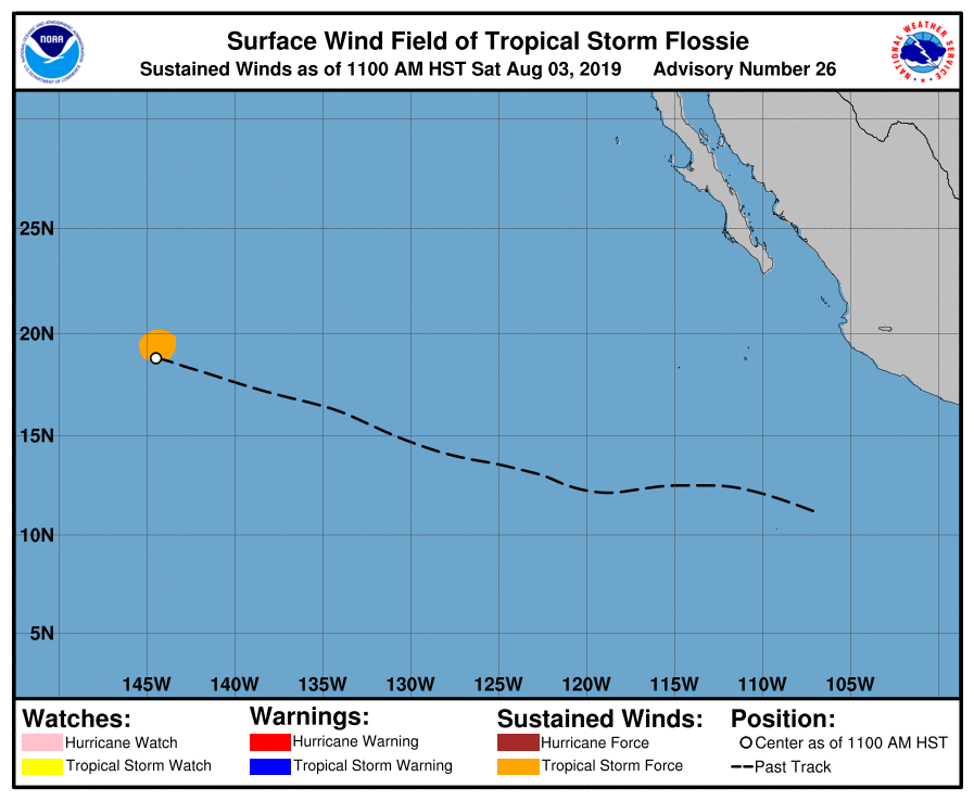
11 AM: FLOSSIE CONTINUING TO MOVE WNW
-

- TS Flossie, 11 AM, Aug. 3, 2019. PC: NOAA
-

- TS Flossie, 11 AM, Aug. 3, 2019. PC: NOAA
-

- TS Flossie, 11 AM, Aug. 3, 2019. PC: NOAA
-

- TS Flossie, 11 AM, Aug. 3, 2019. PC: NOAA
-

- TS Flossie, 11 AM, Aug. 3, 2019. PC: NOAA
-

- TS Flossie, 11 AM, Aug. 3, 2019. PC: NOAA
The satellite presentation of Flossie remains unimpressive this morning, according to the NWS Central Pacific Hurricane Center in Honolulu.
The center of Tropical Storm Flossie is located near latitude 18.8°N, longitude 144.5°W, about 695 miles E of Hilo.
Flossie is moving toward the WNW 13 mph and this motion is expected to continue during the next couple of days.
Maximum sustained winds are near 50 mph with higher gusts. Weakening is forecast during the next 48 hours, and Flossie is expected to become a tropical depression Sunday.
Tropical-storm-force winds extend outward up to 105 miles from the center.
The estimated minimum central pressure is 29.62 inches.
HAZARDS AFFECTING LAND
SURF: Swells generated by Flossie will affect portions of the main Hawaiian Islands over the next couple of days, potentially producing dangerous surf conditions, mainly along E- and SE-facing shores.
11 AM: GIL FORMS OVER EASTERN NORTH PACIFIC

TS Gil, 11 AM, Aug. 3, 2019. PC: NOAA
The center of Tropical Storm Gil is located near latitude 15.0°N, longitude 122.4°W. Gil is
moving toward the WNW near 12 mph. A general westward motion at about the same forward speed is forecast for the next couple of days.
Maximum sustained winds are near 40 mph, with higher gusts.
Little change in strength is forecast during the next day or so. Gradual weakening is anticipated by early next week, and Gill is expected to dissipate by Tuesday.
Tropical-storm-force winds extend outward up to 80 miles from the center.
The estimated minimum central pressure is 29.71 inches.
8 AM: TS Flossie Centered About 740 Miles East of Hilo
5 AM: TS FLOSSIE FLOUNDERING FORWARD
-

- TS Flossie, 5 AM, Aug. 3, 2019. PC: NOAA
-

- TS Flossie, 5 AM, Aug. 3, 2019. PC: NOAA
-

- TS Flossie, 5 AM, Aug. 3, 2019. PC: NOAA
-

- TS Flossie, 5 AM, Aug. 3, 2019. PC: NOAA
-

- TS Flossie, 5 AM, Aug. 3, 2019. PC: NOAA
-

- TS Flossie, 5 AM, Aug. 3, 2019. PC: NOAA
As of 5 a.m. today, the center of Tropical Storm Flossie was located near latitude 18.6°N, longitude 143.5°W, about 760 miles east of Hilo.
There are no Watches, Warnings or Advisories for Hawai‘i Island. A Small Craft Advisory is in effect for Big Island waters until 6 p.m.
Although the environment in which Flossie is currently embedded is not conducive for a hurricane, it is marginally supportive of a tropical storm. However, be aware that Tropical Storms are erratic and can change speed, direction and intensity quickly.
Flossie is moving toward the WNW near 14 mph and this general motion is expected to continue for the next couple of days.
Maximum sustained winds are near 60 mph with higher gusts.
Gradual weakening is forecast during the next couple of days.
Tropical-storm-force winds extend outward up to 140 miles from the center.
The estimated minimum central pressure is 29.47 inches.
HAZARDS AFFECTING LAND
SURF: Swells generated by Flossie will affect portions of the Hawaiian Islands over the next couple of days, potentially producing dangerous surf conditions, mainly along east- and SE-facing shores.
5 AM HST: Tropical Depression Eight-E Forms in E Pacific

Tropical Depression Eight-E, 5 AM, Aug. 3, 2019. PC: NOAA
The center of Tropical Depression Eight-E was located near latitude 14.7°N, longitude 121.2°W.
The depression is moving toward the WNW near 10 mph. A general westward motion at a similar forward speed is expected for the next day or two.
Maximum sustained winds are near 35 mph, with higher gusts.
Gradual weakening is forecast during the next day or two, and the depression is forecast to dissipate by early Monday.
The estimated minimum central pressure is 29.80 inches.
Sponsored Content


