

‘Heaviest rain is still likely yet to come’: Storm’s worst impacts expected to arrive today
A hard rain pelted rooves and drowned out most other sounds at about midnight today (Jan. 5) in Hilo as another rainband spiraling outward from a possible kona low near the state moved over the Big Island.
It was like a translucent curtain hanging from the night sky somewhat swamping the illuminated streetlights, reminiscent of the sauntering sulfur smoke shroud that thickened the air just a few days earlier during New Year’s Eve fireworks festivities.
Heavy rains picked up the pace by 8 a.m., with what seemed like one round after another falling from the heavens onto Hilo.
Rain will continue through today, likely a good portion of Tuesday (Jan. 6) — at times becoming torrential — and possibly even into Wednesday (Jan. 7) as what forecasters at the National Weather Service Honolulu office started off calling a cold-core cyclone moves west of the islands by midweek, beginning to weaken later today and into Wednesday.
Many models show the main impacts from the storm — heavy rainfall, flooding, possible high winds, potential thunderstorms and a snowstorm atop Big Island summits on Mauna Kea and Mauna Loa — still to come, with some of the worst conditions expected late today and Tuesday.
“The heaviest rain is still likely yet to come for the Big Island, and [we] will likely see continuous periods of moderate to heavy rain today and tonight,” said National Weather Service Honolulu forecaster Genki Kino. “Big Island should see heavy rain increase during the day today as another round of moisture makes its way in, and it will likely persist through tonight and linger through Tuesday.”
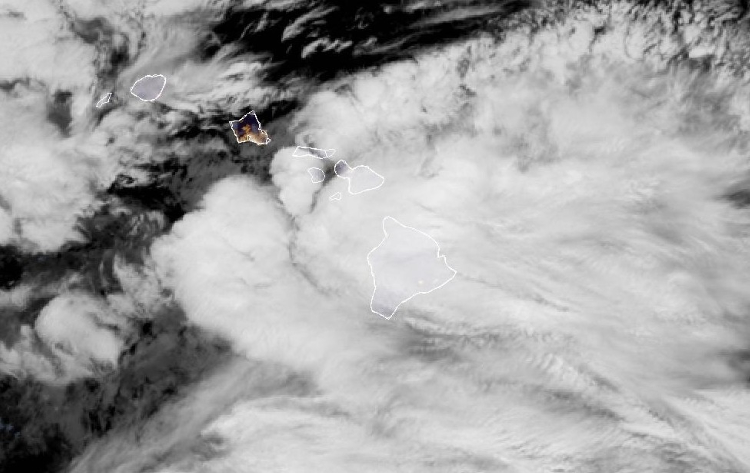
Several areas in the southeast portion of the Big Island already recorded major amounts of rainfall Sunday.
Flood advisories were issued for that area and the entire island of Kauaʻi at different points throughout the day as heavy rainfall — generally falling at a rate of 1 to 2 inches an hour, with some places experiencing up to 3 inches an hour — moved over the state.
Another flood advisory is in effect this morning — extended until 11 a.m. — for eastern and southeastern portions of the Big Island.
National Weather Service automated rain gauges in Mountain View and Glenwood each provisionally collected more than 3 inches of rain during a 24-hour period ending at 11:45 p.m. Sunday, with the Glenwood gauge reaching nearly 3.5 inches.
Waiākea Uka in the Hilo area received an unofficial 1.65 inches of rain. The Hilo Airport rain gauge collected a provisional 1.18 inches, with one of the two nearby Pi‘ihonua collection sites reporting in with 1.41 inches.
Each of the two Pāhoa rain gauges also saw more than an inch of rain unofficially, as well as the Waiākea Experiment Station that collected nearly 1.5 inches.
Both Kapāpala rain collectors provisionally recorded more than 1 inch, with the Kapāpala Ranch gauge collecting nearly 2 inches of rain during the same 24-hour period.
Even larger amounts of rainfall were recorded in a few other places on the island, including at Nāhuku, near Thurston Lava Tube inside Hawaiʻi Volcanoes National Park, with an unofficial 2.71 inches or rain and the Pali 2 rain gauge site near Volcano and Glenwood, with a provisional 4.72 inches.
The most rainfall collected during the 24-hour time frame from Saturday night through Sunday night was by the Kealakomo gauge inside Hawaiʻi Volcanoes National Park, about 6.5 miles southeast of the 1969-74 Maunaulu eruption site — near the Puna Coast and close to the Kaʻū boundary — which recorded a whopping 6.03 inches of rain.
That’s the unofficial amount reported by the National Weather Service office in Honolulu; however, the rain gauge’s website says it collected 6.23 inches of rain by 11:45 p.m. Sunday.
Kino said there were also radar estimates of up to 9 inches between Kealakomo and Nāhuku.
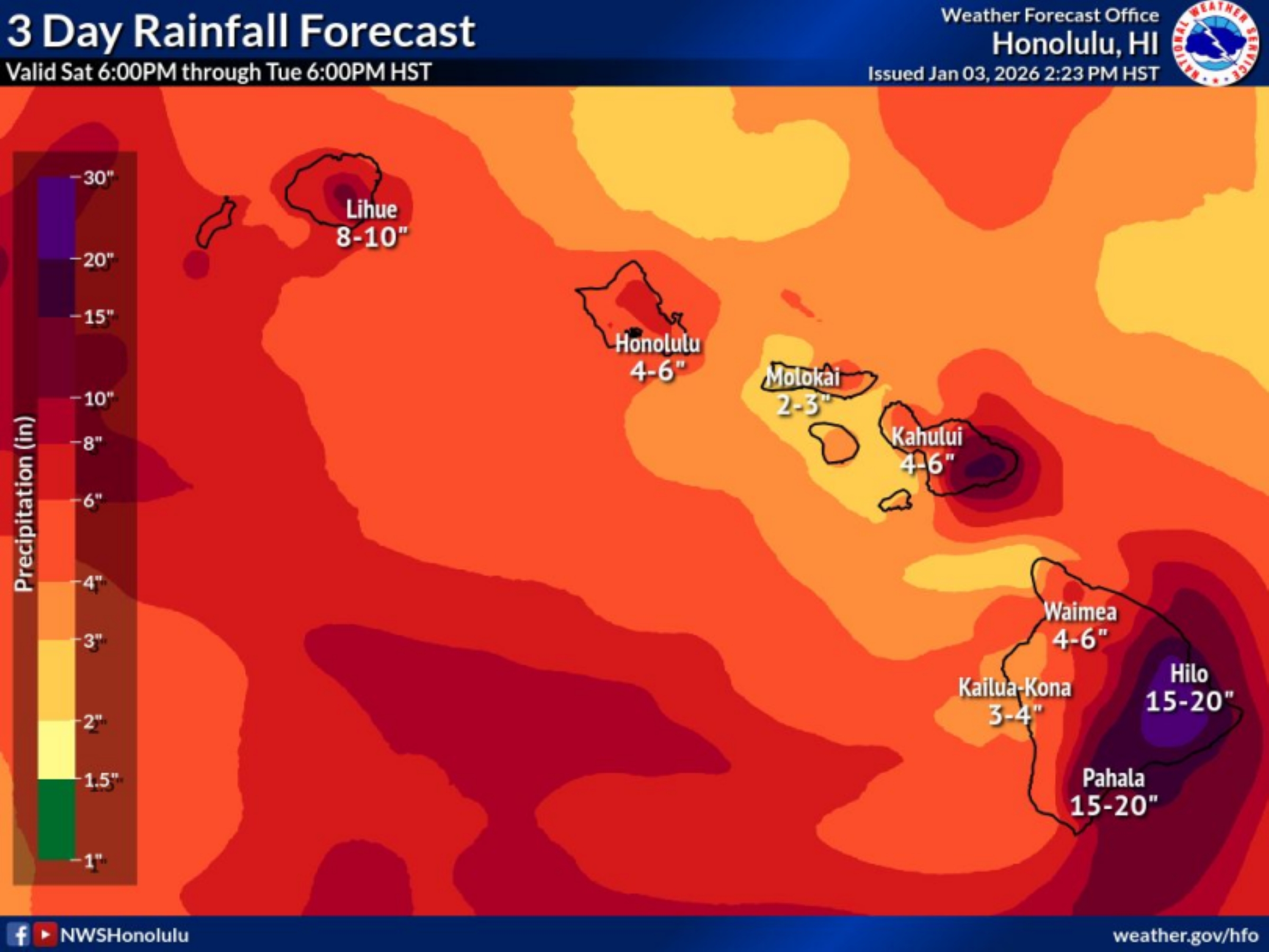
“After all said and done,” he added, “we will likely see areas, especially around southeast Big Island, with 15 to 20 inches of storm total rain.”
Southeast Big Island includes communities such as Hilo, Pāhoa, Glenwood, Volcano, Pāhala, Wood Valley and Nāʻālehu.
“Kauaʻi remains a tricky forecast due to the bulk of the moisture passing near or just south of Kauaʻi,” Kino said, adding the Honolulu forecast office expects anywhere from 3 to 10 inches of rain total from today through Tuesday for locations on the Garden Isle.
The highest rainfall totals are expected over Mount Waiʻaleʻale.
Several automated National Weather Service rain gauges on Kauaʻi provisionally collected an inch or more of rain already Sunday as the storm’s first rainbands moved over the island, including the Mōhihi Crossing site with 1 inch, Hanalei with 1.04 inches, Waiahi Rain Gauge recording 1.07 inches, Common Ground with 1.47 inches, Puʻu ʻŌpaʻe with 1.51 inches, Puʻu Lua collecting 1.53 inches and Mount Waiʻaleʻale coming in at 1.63 inches.
However, the highest unofficial rainfall totals were marked by three other gauges: the North Wailuā Ditch site with 2.25 inches, Kilohana with 2.38 inches and Waiakoali collecting 2.68 inches.
In comparison, the only other rain gauge site in the state to collect more than a provisional 2 inches of rain Sunday was at Kuaokalā on Oʻahu with 2.09 inches. Only one other location throughout the islands also recorded more than an unofficial 3 inches: Nā Kula on Maui with 3.52 inches.
“Latest near-term model guidance shows the the greatest potential for excessive rain and flooding potential to occur over Kauaʻi County and along southeast and eastern exposures of Big Island and Maui County today and tonight,” said the 4:01 a.m. area forecast discussion from today by the National Weather Service. “However, the convective nature of this pattern will still keep some potential of heavy rain and thunderstorms over the rest of the state.”
Hawaiʻi News Now weekend meteorologist Ben Gutierrez reported in his forecast the night of Jan. 3 that some of that heavy rainfall could even transfer to North Hawai‘i on the Big Island through Wednesday.
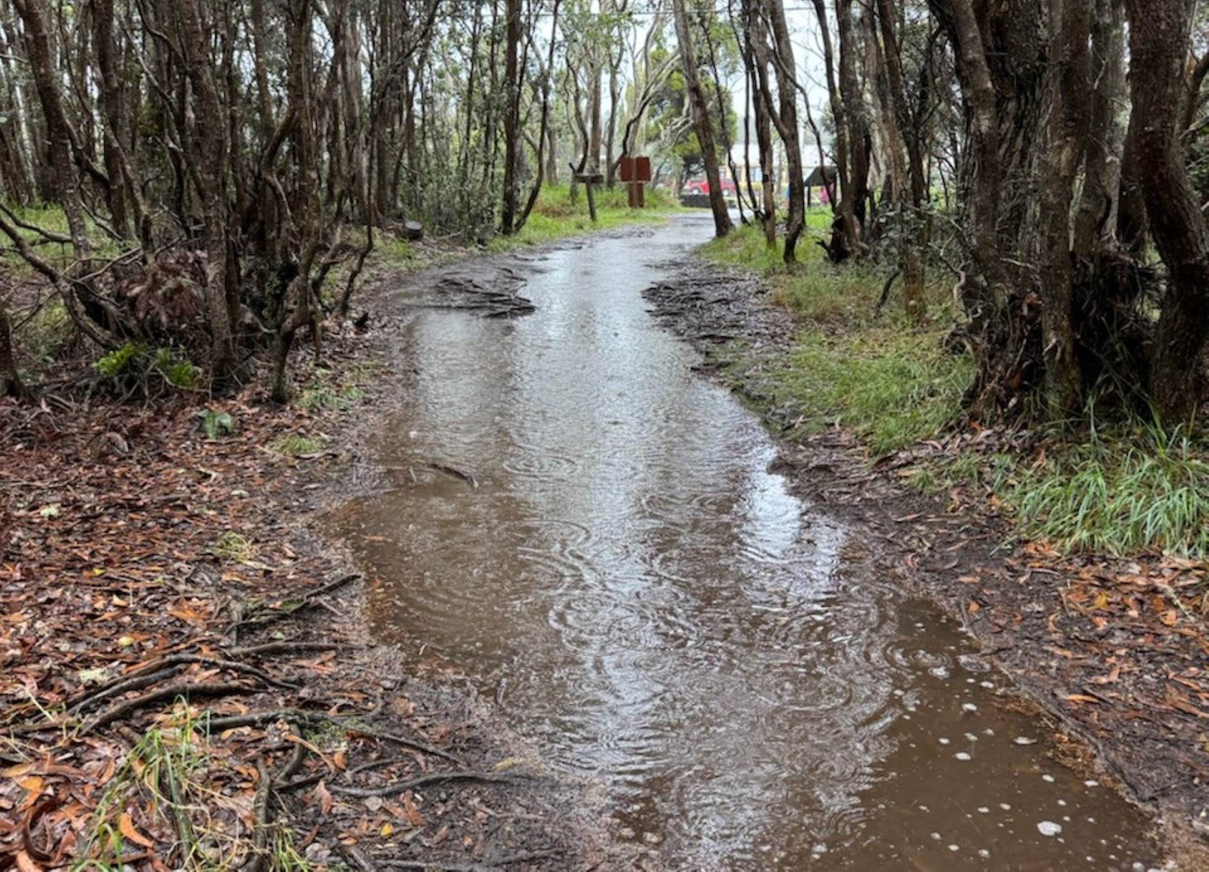
That means a threat of flooding — including flash flooding — will persist, with Honolulu forecasters saying the flood watch now in effect through today for the entire state might, and likely will, be extended.
Sites that saw soggier shower sums Sunday and at the end of last week also could be at a higher flood risk as they are already saturated.
“It should be noted that the models have trended closer to our island, with the upper level low over the past 48 hours, increasing the likelihood of flooding for us,” wrote citizen meteorologist and administrator/founder of the Puna Weather group on Facebook Harry Durgin in a Sunday morning post.
He added — much to the disdain and dismay of several group members and commenters not wanting anything to do with having to cope with a similar situation — that Hurricane Lane in 2018 is a good comparison to this storm, as that tropical cyclone was also an upper level low.
“I know we were calling for a kona low, but I am not sure if a kona low actually did develop,” Kino said early today. “It’s been tough with all of the cloudiness to see if a surface low did actually develop with this system or not. The latest surface analysis, we could not find a surface low, so we analyzed it as a trough.”
Either way, expected impacts won’t change.
“So keep the umbrellas out and be prepared in case flash flood warnings are issued,” Gutierrez said during his nighttime Jan. 3 weather segment.
Storm effects also include strong and gusty winds becoming part of the mix today, Kino said, which could warrant a wind advisory — issued when sustained winds reach 30 to 39 mph and/or gusts up to 50 mph are forecast — for lower elevations of the Big Island and Maui.
“It will be windy on Kaua’i, too, but most likely not at wind advisory criteria,” he added.
Durgin’s forecast called for breezy east or southeast winds that could become quite strong — “capable of downing tree branches and causing power outages.” Flooded roads then would be even more of an issue if utility crews are delayed in restoring power because of them.
Isolated thunderstorms also can be expected.
Plus, what would a big storm system dragging up deep moisture from the south of the islands be without a good old-fashioned winter wallop for the summits of Mauna Kea and Mauna Loa?
Both are under a winter storm warning and high wind warning as the storm system lofts that deep moisture at and above the 11,000-foot level.
National Weather Service forecasts heavy snow atop the the volcanoes, with total snow accumulations of 5 to 10 inches.
Significant accumulation of rime ice — a white, opaque, granular and brittle ice that forms when supercooled water droplets in fog or clouds freeze rapidly onto surfaces, trapping air and creating a rough texture — is also possible on summit roadways.
“Due to the strong winds, it is always tough to see how much snow actually fell [at the summits], but I would [expect] 1- to 2-[foot] drifts up there,” Kino said.
Winds are expected to ramp up even more later this afternoon and into tonight at the summits, too, he added, with gusts up to 75 mph.
Weather conditions at the summit of Mauna Kea as of about 7:15 a.m. today showed temperatures ranging from near 31 degrees to almost 42 degrees, with wind speeds from 6 mph up to 21 mph and the strongest gust at 21 mph so far.
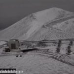
 A webcam image from the summit of Mauna Kea as of 6 a.m. Jan. 5, 2026. (Image Courtesy: Mauna Kea Weather Center website)
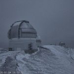
- Webcam image from the Mauna Kea summit as of the early evening of Jan. 4, 2026. (Image Courtesy: Onizuka Center for International Astronomy Visitor Information Station Facebook page)
- A webcam image of the Mauna Kea summit as of 6:17 p.m. Jan. 4, 2026. (Image Courtesy: Onizuka Center for International Astronomy Visitor Information Station Facebook page)
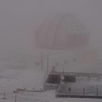
- Webcam image as of 4:35 p.m. Jan. 4, 2026, at the Mauna Kea summit. (Image Courtesy: Onizuka Center for International Astronomy Visitor Information Station Facebook page)
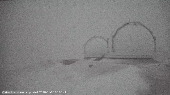
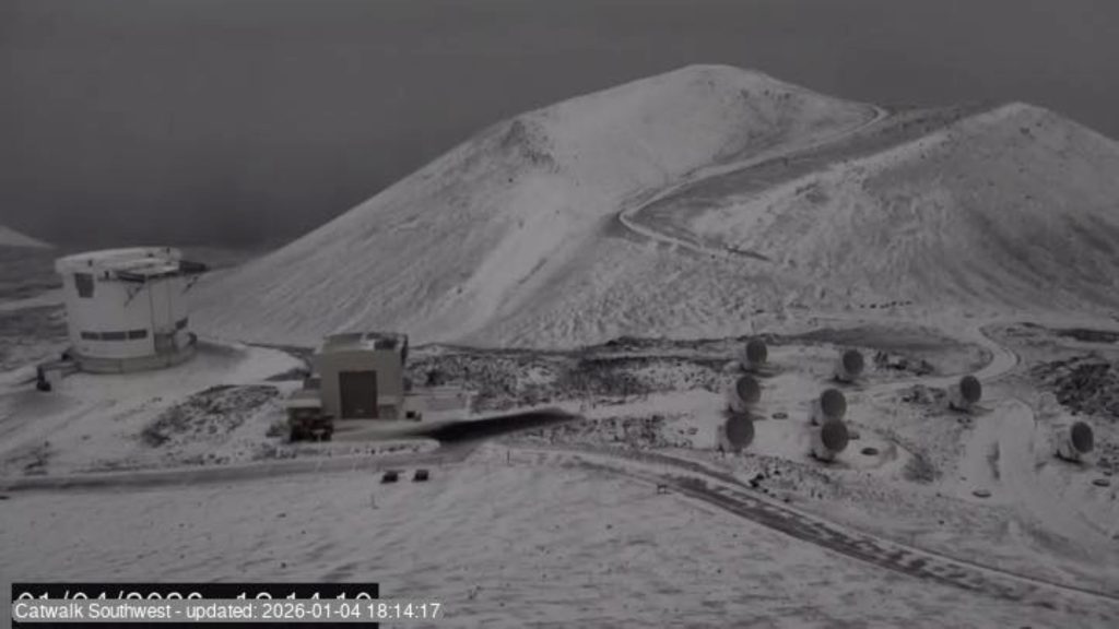
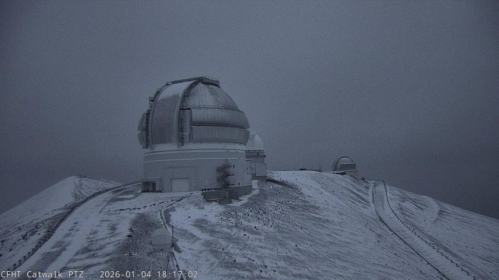
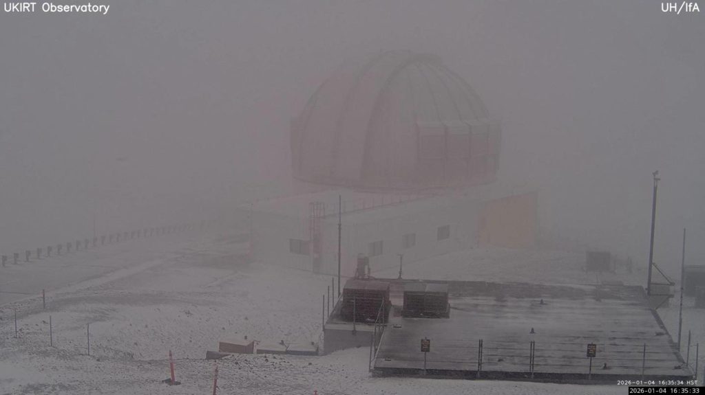
Webcams at the Mauna Kea observatories also show snowfall this morning, with accumulation, as well as ice.
Onizuka Center for International Astronomy Visitor Information Station reports that Mauna Kea Access Road is closed above the visitor center, which sits at an elevation of 9,200 feet, because of the storm as well as additional winter weather expected during the next few days.
Check road conditions to the summit online.
The snowstorm settling in over the Big Island mountaintops also resulted in Hawaiʻi Volcanoes National Park closing the Mauna Loa trail through Monday from the lookout to Red Hill Cabin at Puʻuʻulaʻula. Park officials wrote in a Sunday Facebook post that park rangers will re-evaluate the situation Tuesday.
They also made sure everyone knows — despite the weather — the national park remains open, “but it’s wet!”
“Dress for rain and puddles if you visit; be very careful on roadways, trails and crosswalks due to reduced visibility, the potential for fallen trees and heavy rain,” said the park’s post.
Visit the National Weather Service Honolulu forecast office website for additional details from this morning’s area forecast discussion and to get the most up-to-date information about any advisories, watches and/or warnings issued while the so-called cold-core cyclone continues bringing inclement and possible severe weather to the state.
Sponsored Content

_1770333123096.webp)

