

UPDATE: High surf advisory for east-facing shores of Big Island canceled
Update at 3:51 a.m. Jan. 7, 2026: National Weather Service forecasters in Honolulu canceled the high surf advisory that was previously in effect for east-facing shores throughout the state, including the Big Island.
Forecasters report that surf has fallen below advisory levels along those shorelines; therefore, a high surf advisory is no longer needed.
This was the last advisory, watch or warning to end or be canceled since late last week when the National Weather Service started issuing inclement and severe weather statements and products because of anticipated impacts from what was likely not a “classic” kona low.
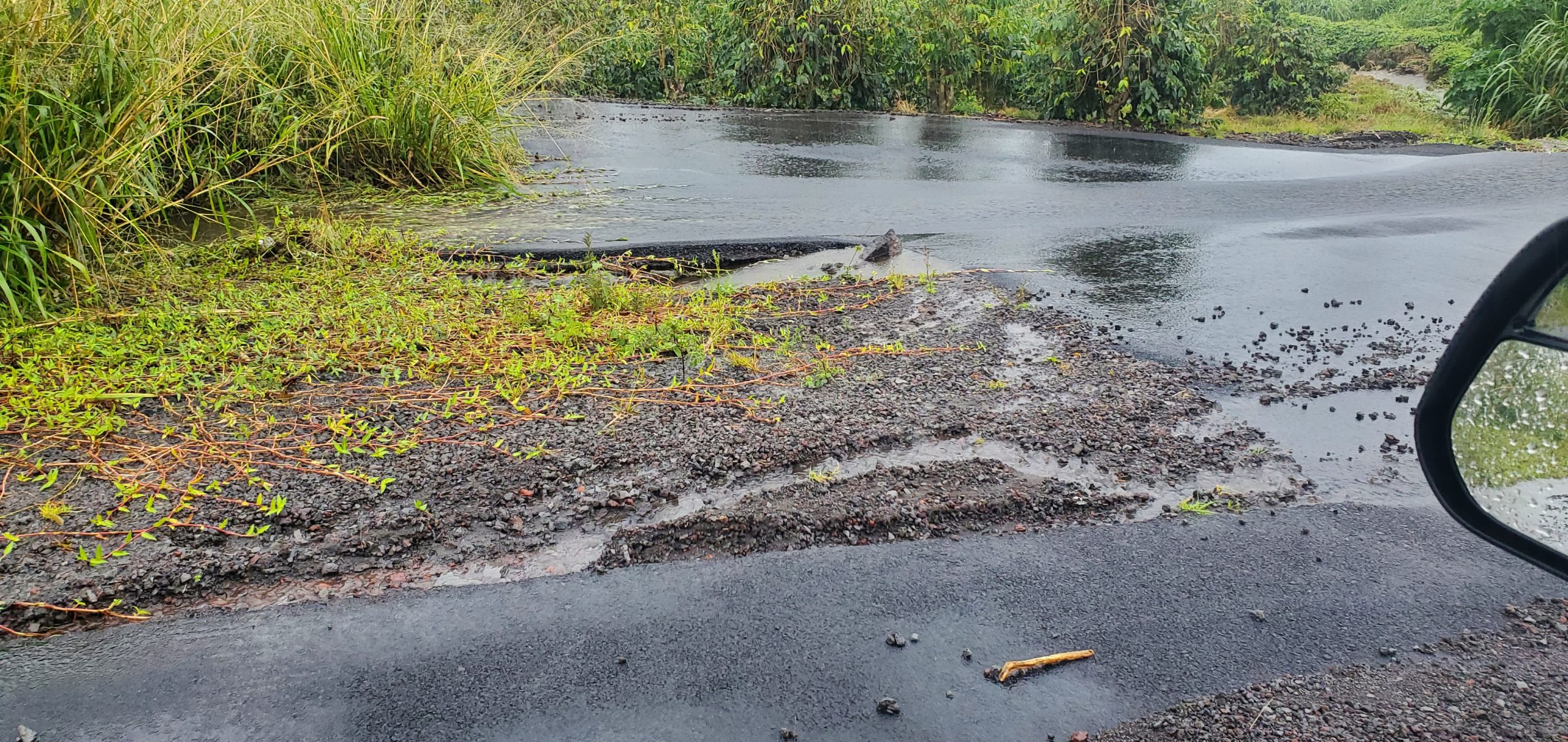
Update at 7:40 a.m. Jan. 6: Portions of Highway 11 in the Ka‘ū District have since reopened after the roadway was closed Monday due to flooding at mile markers 62 and 56.
The National Weather Service in Honolulu has also canceled its flood advisory and flood watch for Hawai‘i Island.
Update at 9 p.m. Jan. 5: The National Weather Service has extended a flood advisory for the Hāmākua, Hilo, Puna, and the Kaʻū districts.
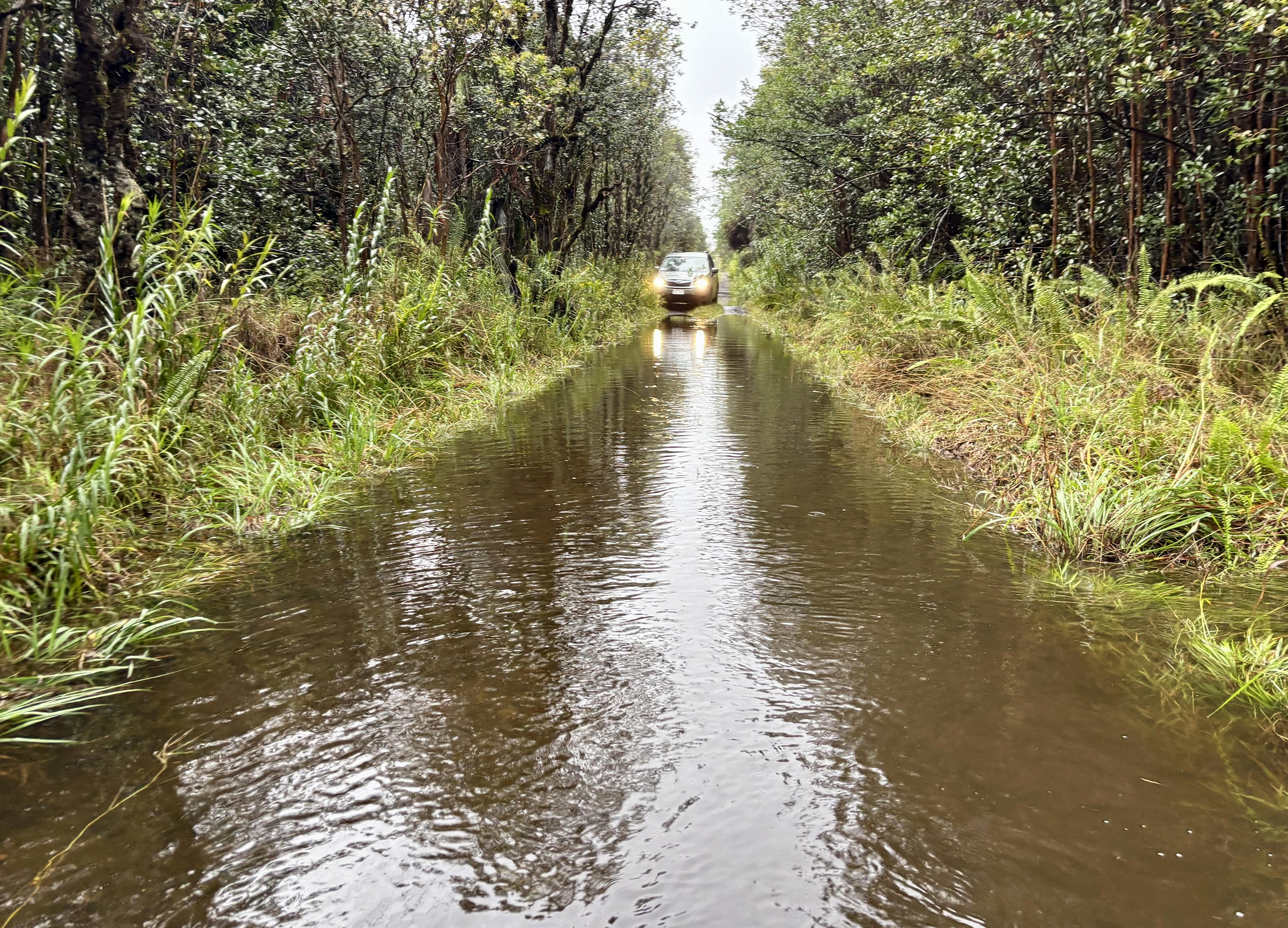
Around 5:45 p.m., the Hawaiʻi Police Department put out a statement to avoid Laupāhoehoe Point Road due to a landslide that likely started due to the rainfall.
More information and details are expected and it is unknown how long the road will be closed.
Then, around 10:30 p.m., the Hawaiʻi Police Department advised drivers to avoid Highway 11 (between the 62-mile marker and the 56-mile marker)in Ka‘ū due to a road closure from the result of flooding. No alternate routes are available.
All other districts of Hawaiʻi Island are under a flood watch. While a flood advisory means flooding is occurring, a flood watch means flooding is possible.
The Hawaiʻi County Civil Defense Agency reminds residents in flood-prone areas that road closures may occur without notice and to not attempt to cross flowing water in a vehicle or on foot.
Hawaiʻi police have closed Laupāhoehoe Point Road due to a reported landslide.
For more information, please visit the County of Hawaiʻi Hazard Impact Map.
Update at 1:43 p.m. Jan. 5: A flood advisory on Hawai‘i Island is once again extended till 5 p.m.
At 1:39 p.m., radar indicated that heavy rain continues over windward Big Island. Rain was falling at a rate of 1 to 2 inches per hour.
Some locations that will experience flooding include Hilo, Hawaiian Paradise Park, Honoka‘a, Volcano, Glenwood, Hawai‘i Volcanoes National Park, Mountain View, Hawaiian Acres, Wood Valley, Kea‘au, Orchidlands Estates, Pāhala, Pāhoa, Papaikou, Pepe‘ekeo, Punalu‘u Beach, Honomu, Kawa Flats and Hakalau.
Update at 10:39 a.m. Jan. 5: A flood advisory issued for Hawai‘i Island is extended to 2 p.m.
At 10:35 a.m., radar indicated that heavy rain continues over windward Big Island. Rain was falling at a rate of 1 to 2 inches per hour.
Some locations that will experience flooding include Hilo, Hawaiian Paradise Park, Honokaa, Volcano, Glenwood, Hawai‘i Volcanoes National Park, Mountain View, Hawaiian Acres, Wood Valley, Kea‘au, Orchidlands Estates, Pāhala, Pāhoa, Papaikou, Pepe‘ekeo, Punalu‘u Beach, Honomu, Kawa Flats and Hakalau.
Minor flooding is expected on roads, poor drainage areas, and in streams.
Update at 7:46 a.m. Jan. 5: A flood advisory for portions of the Big Island has been extended till 11 a.m.
As of 7:41 a.m., radar indicated heavy rain over the windward Big Island. Rain was falling at a rate of 1 to 2 inches per hour at times.
Some locations that will experience flooding include Hilo, Hawaiian Paradise Park, Honoka‘a, Volcano, Glenwood, Hawai‘i Volcanoes National Park, Mountain View, Hawaiian Acres, Wood Valley, Kea‘au, Orchidlands Estates, Pāhala, Pāhoa, Papaikou, Pepe‘ekeo, Punalu‘u Beach, Honomu, Kawa Flats and Hakalau.
Original post: National Weather Service forecasters in Honolulu issued a flood advisory for eastern and southeastern portions of the Big Island in effect until 8 a.m. today (Jan. 5) because of excessive rainfall moving over those areas and causing likely flooding.
Radar indicated at 4:51 a.m. that heavy rain was falling at a rate of 1 to 2 inches per hour over windward Big Island, with the heaviest rain along a line from Laupāhoehoe southward to Volcano.
Some locations that will experience flooding include Hilo, Hawaiian Paradise Park, Honokaʻa, Volcano, Glenwood, Hawaiʻi Volcanoes National Park, Mountain View, Hawaiian Acres, Wood Valley, Keaʻau, Orchidlands Estates, Pāhala, Pāhoa, Pāpaʻikou, Pepe‘ekeo, Punaluʻu Black Sand Beach, Honomū, Kawa Flats and Hakalau.
Flooding can be expected on roads as well as in poor drainage areas and streams.
The public is advised to stay away from streams, drainage ditches and low-lying areas prone to flooding.
Sponsored Content

_1770333123096.webp)

