

UPDATE: High surf advisory for east-facing shores canceled as northeast swell diminishes
Update at 3:19 p.m. Nov. 14, 2025: National Weather Service forecasters in Honolulu report that a short-period northeast swell that was causing advisory level surf along the east-facing shores of the Big Island has fallen today (Nov. 14) and will decline further through tomorrow as trade winds ease.
Therefore, the high surf advisory in effect for eastern shorelines of the island until early Saturday morning (Nov. 15) was canceled.
Visit the National Weather Service Honolulu forecast office website for the most up-to-date weather information available, including any watches, warnings, advisories and more.
Update at 4:58 p.m. Nov. 13, 2025: High surf pounding east-facing shores of the Big Island just won’t quit, and is now expected to remain above advisory level even longer.
National Weather Service forecasters in Honolulu extended the high surf advisory for eastern shorelines of the island again Thursday afternoon (Nov. 13), with it now in effect until 6 a.m. Saturday (Nov. 15).
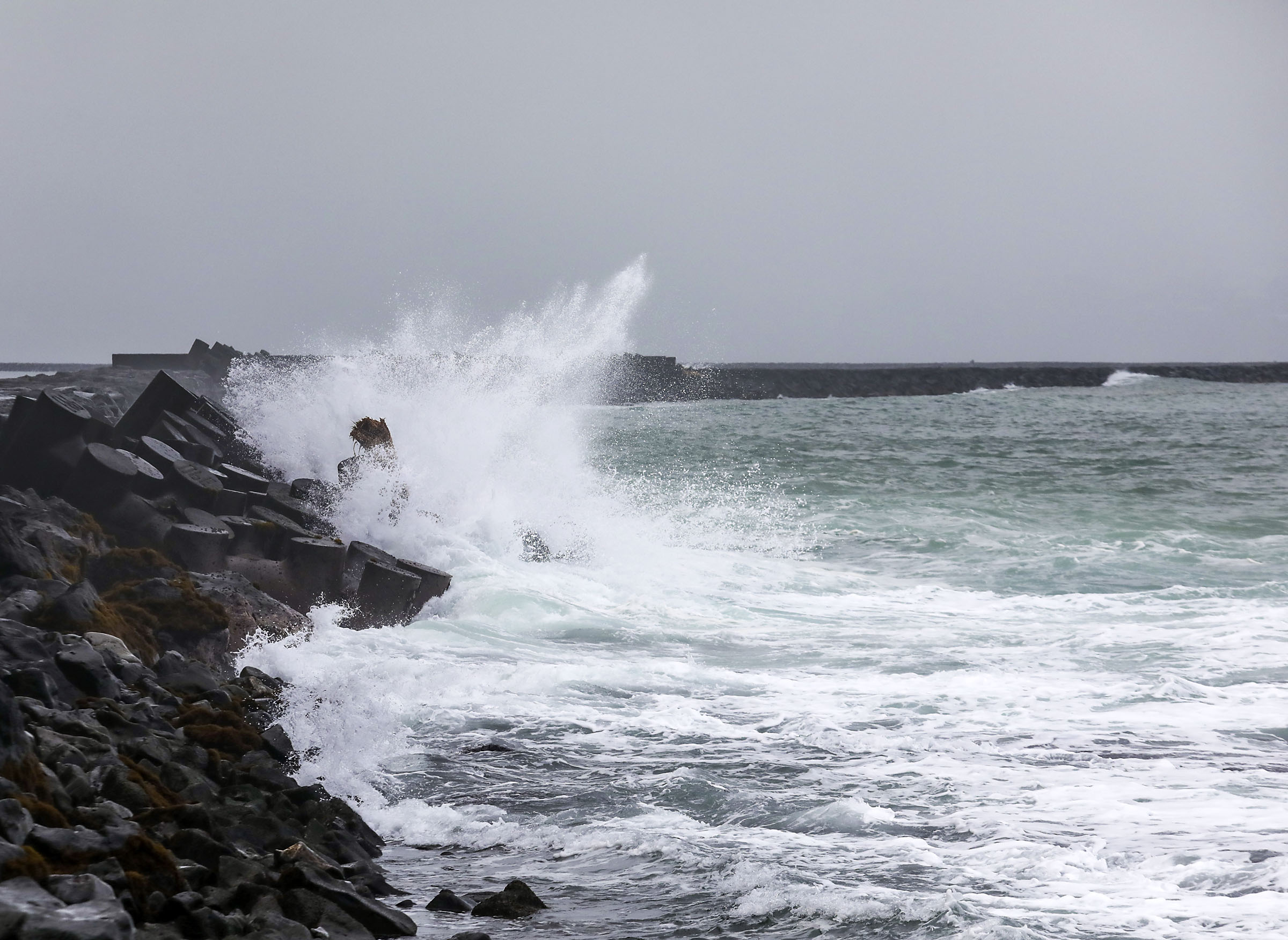
Large breaking waves of 8 to 12 feet continue to be expected through tonight, but should subside to 7 to 10 feet Friday (Nov. 14).
Those waves combined with strong currents will make swimming at any locations along east-facing shores dangerous.
Forecasters remind the public to heed all advice from ocean safety officials — when in doubt, don’t go out.
Surf along eastern shorelines is being affected by strong trade winds near and upstream of the islands, which has produced the large and rough conditions. The primary swell direction of the short-period swell will be northeasterly.
Meanwhile, winds have declined to below advisory thresholds around the island, so forecasters in Honolulu canceled the wind advisory that was previously in effect until 6 p.m. today (Nov. 13) for Hāmākua, Hawaiʻi Island interior, Kaʻū, North and South Kohala, portions of Puna and North Kona.
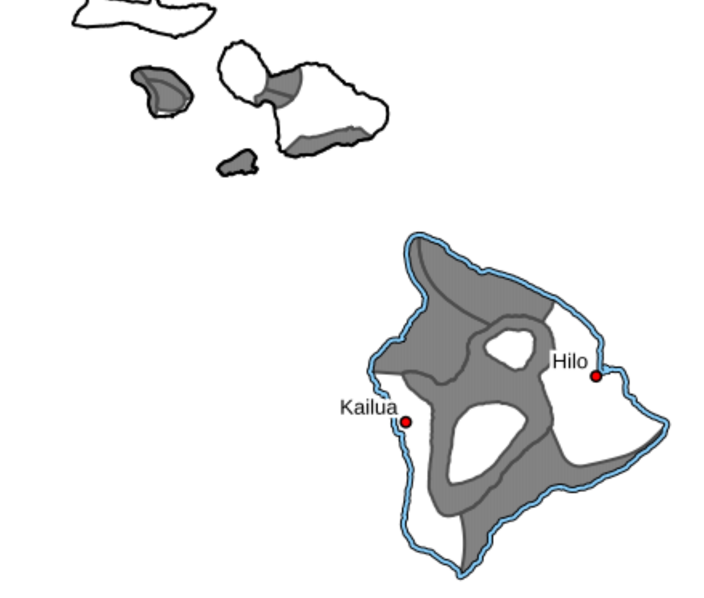
Update at 8:22 a.m. Nov. 13, 2025: Coconut Island and County beach parks in Keaukaha will remain closed today due to high surf.
A wind advisory remains in place for Hāmākua, Ka‘ū, North Kona and South Kohala Districts as well as Hawai‘i Island’s interior.
The National Weather Service reports winds of at least 30mph and/or frequent gusts of at least 50 mph are expected.
Additionally, a surf advisory remains in place for east- and north-facing shores of Hāmākua and Hilo through tonight.
Update at 5 a.m. Nov. 13, 2025: The wind advisory for portions of the Big island has been extended to 6 p.m. Thursday, according to the National Weather Service.
The forecast is for northeast to east winds of 25 to 35 mph with gusts up to 55 mph.
Winds this strong can tear off shingles, knock down tree branches, blow away tents and awnings and make it difficult to steer, especially for drivers of high profile vehicles.

Update at 4:52 p.m. Nov. 12, 2025: Hawaiʻi County Civil Defense reported in its afternoon message that a wind advisory for Hāmākua, Hawaiʻi Island interior, Kaʻū, North and South Kohala, portions of Puna and North Kona continues through Thursday (Nov. 13).
A high surf advisory for east-facing shores of the island also continues.
Officials reported Bayfront Highway in Hilo, however, is now again open to all traffic. The Hāmākua-bound lane was previously closed because of weather impacts.
Unfortunately, they also said Hawaiʻi County beach parks in the Keaukaha community of Hilo will continue to remain closed through at least today.
The high surf advisory for north-facing shores was canceled the afternoon of Nov. 11 by National Weather Service forecasters in Honolulu, reporting that strong trade winds near and upstream of the islands was already producing large and rough surf along eastern shorelines.
Direction of the the primary swell also shifted from north-northeast to northeast.
As a result, north shore surf declined below advisory levels; however, large surf is expected to persist along east-facing shores, with waves of 10 to 14 feet forecasted.
The high surf advisory for those shorelines remains in effect until 6 p.m. Thursday.
Meanwhile, northeast to east winds sustained winds of 25 to 35 mph, with gusts up to 55 mph, will continue to blow across the majority of the Big Island, as the wind advisory also remains in place through 6 p.m. Thursday.
Update at 8:35 a.m. Nov. 12, 2025: Blustery conditions and high surf are expected to persist across parts of Hawaiʻi Island through Thursday evening, according to the National Weather Service.
A Wind Advisory remains in effect for the districts of Hāmākua, Hawaiʻi Island Interior, Kaʻū, North and South Kohala, and North Kona. Forecasters warn of sustained winds reaching 30 miles per hour with gusts up to 50 miles per hour.
In addition, a High Surf Advisory continues for east- and north-facing shores of Hāmākua and Hilo.
Local officials report that the Hāmākua-bound lane of Bayfront Highway in Hilo remains closed due to the ongoing weather, and county beach parks in Keaukaha will stay closed today for public safety.
Authorities urge residents to use caution, secure loose outdoor items, and avoid shoreline areas until conditions improve.
Original Post: National Weather Service forecasters in Honolulu issued a wind advisory for most of the Big Island that will remain in effect until 6 a.m. Thursday (Nov. 13).
Sustained winds of 25 to 35 mph — with gusts of up to 55 mph — are expected in areas including Kohala, portions of Kaʻū, Kona, Puna, Hāmākua and Humuʻula Saddle region (between Mauna Kea and Mauna Loa).
Winds at those speeds can tear off shingles, knock down tree branches, blow away tents and awnings and make it difficult to steer, especially for drivers of high profile vehicles.
The public is advised:
- Watch out for falling tree branches when walking or driving.
- Make sure tents and awnings are secure or taken down.
- Be prepared for power outages.
- Stay clear of downed utility lines and report all hazards to authorities.
- Secure trash cans, lawn furniture and other loose outdoor objects that can be easily blown around by strong winds.
Low humidity levels combined with the strong winds led to a Public Safety Power Shutoff Program Watch for the Big Island as well, with Hawaiian Electric keeping a close eye on the conditions with the increased risk of wildfires being sparked.
Sponsored Content


