

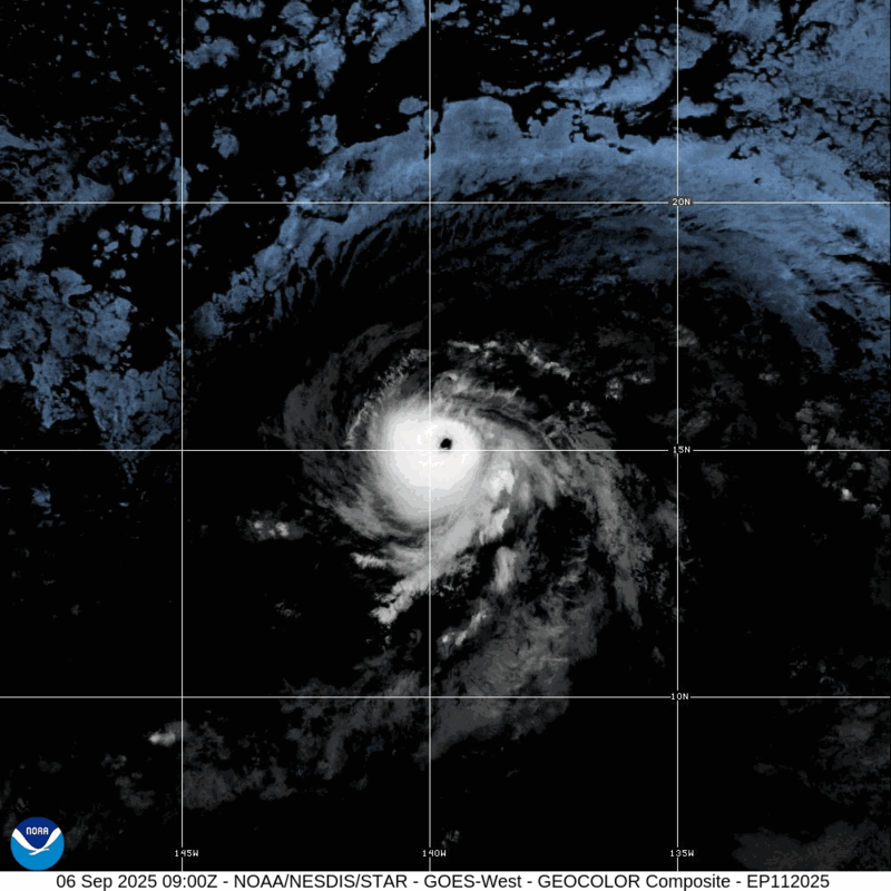
Update #8: Kiko enters Central Pacific Basin as category 4 Hurricane, now 1,000 miles from Hilo
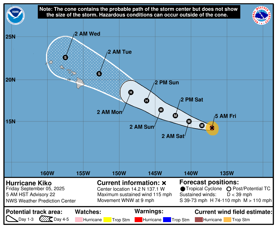
Update #8, 5 a.m. Sept. 6: While there remain no coastal watches or warnings in effect for the Hawaiian Islands, residents should monitor the progress of category 4 Hurricane Kiko as it moves closer to the island chain, according to the National Hurricane Center.
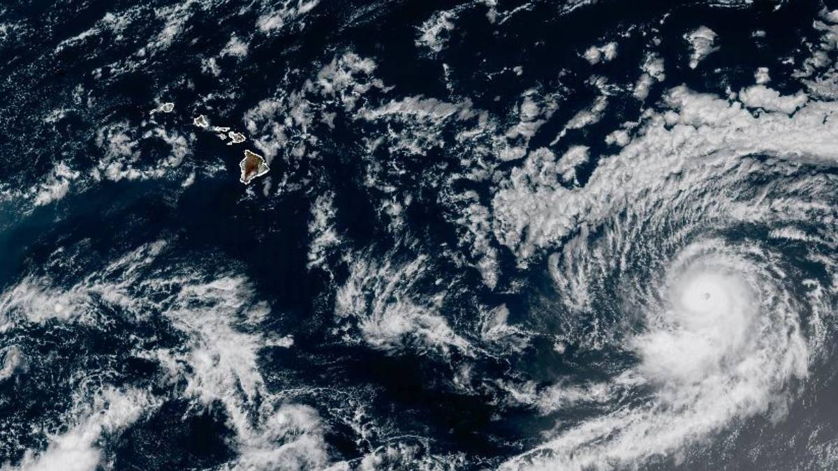
As of 5 a.m. on Saturday, Kiko was 1,005 miles east-southeast of Hilo, and moving west-northwest at 12 mph. This general motion is expected to continue for the next few days.
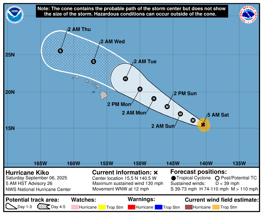
The projected forecast has the eye of the hurricane passing north of the Hawaiian Islands, beginning on Tuesday.
But swells generated by Kiko are expected to begin reaching the Big Island by Sunday, according to the National Hurricane Center.
The swells are forecast to gradually build and peak along east facing shores of the Hawaiian Islands late Monday through midweek, potentially producing life-threatening surf and rip currents.
Now, Kiko has maximum sustained winds near 130 mph with higher gusts, making it a category 4 hurricane on the Saffir-Simpson Hurricane Wind Scale. But gradual weakening is expected over the next several days.
Hurricane-force winds extend outward up to 25 miles from the center and tropical-storm-force winds extend outward up to 80 miles.
The National Weather Service in Honolulu will put out advisories and possible warnings if necessary as the hurricane gets closer to the islands.
Acting Governor Sylvia Luke issued an emergency proclamation declaring a state of emergency across Hawai‘i due to the possible inclement weather posed by Hurricane Kiko.
For hurricane preparation and safety tips, click here.
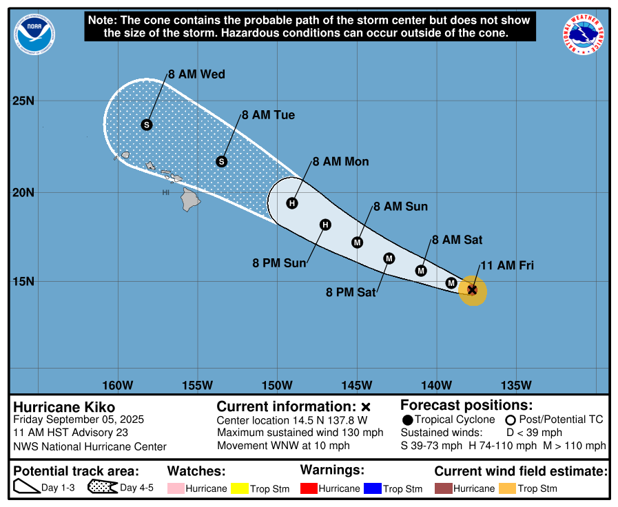
Update #7, 5 p.m. Sept. 5: Swells generated by Hurricane Kiko are expected to begin reaching the Big Island by Sunday, according to the National Hurricane Center.
The swells are forecast to gradually build and peak along east facing shores of the Hawaiian Islands late Monday through midweek, potentially producing life-threatening surf and rip currents.
Hurricane Kiko remains a category 4 hurricane on the Saffir-Simpson Hurricane Wind Scale. Additional strengthening is possible overnight and into Saturday before gradual weakening begins by Sunday.
As of 5 p.m., the center of Hurricane Kiko was located about 1,130 miles east of Hilo and is moving west-northwest near 12 mph. This motion is expected to continue over the next few days.
Hurricane-force winds extend outward up to 25 miles from the center and tropical-storm-force winds extend outward up to 80 miles.
The National Weather Service in Honolulu will put out advisories and possible warnings if necessary as the hurricane gets closer to the islands.
Update #6, 11 a.m. Sept. 5: Kiko quickly re-intensified into a Category 4 hurricane as it continues its approach to the Hawaiian Islands.
As of 11 a.m., Kiko was 1,195 miles east-southeast of Hilo and 1,400 miles east-southeast of Honolulu with maximum sustained winds at 130 mph, according to a public advisory from the National Hurricane Center. Additional strengthening is expected this afternoon and tonight before slow weakening begins on Saturday.
Kiko is moving toward the west-northwest near 10 mph and this motion is expected to continue over the next few days. On the forecast track, Kiko is expected to move into the central Pacific basin by tomorrow morning.
Hurricane-force winds extend outward up to 25 miles from the center and tropical-storm-force winds extend outward up to 70 miles.
While there are no coastal watches or warnings currently in effect, swells generated by Hurricane Kiko could begin reaching the Hawaiian Islands toward the end of this weekend. These swells could cause life-threatening surf and rip currents.
This general west-northwestward motion, along with a gradual increase in forward speed, is forecast into early next week, as Kiko moves along the southwest periphery of this subtropical ridge and toward the upper-level low to the north and northwest of the Hawaiian Islands.
Update #5, 5 a.m. Sept. 5: Hurricane Kiko remains a Category 3 hurricane as it heads in the direction of the Hawaiian Islands.
As of 5 a.m. on Friday, it was about 1,245 miles south-southeast of Hilo.
While there are no coastal watches or warnings in effect now, the National Hurricane Center said people in the Hawaiian Islands should monitor the progress of Kiko.
Swells generated by Kiko could begin reaching the Hawaiian Islands towards the end of this weekend. These swells could cause life-threatening surf and rip currents, the National Hurricane Center said.
Kiko is moving west-northwest at nearly 9 mph and is expected to continue in this direction through the weekend with a slight increase in speed.
Kiko now has maximum sustained winds near 115 mph with higher gusts. Fluctuations in intensity are expected during the next 48 hours followed by weakening by early next week.
Hurricane-force winds extend outward up to 25 miles from the center, with tropical storm-force winds extending outward up to 70 miles.
Update #4, 5 p.m. Sept. 4: Hurricane Kiko weakens to a Category 3 storm as it continues west toward Hawaiʻi at 5 p.m. Thursday.
According to the National Hurricane Center, Hurricane Kiko is moving near 9 mph with a gradual turn west-northwest expected tonight and Friday. This motion is forecast to continue through the weekend with a slight increase in forward speed.
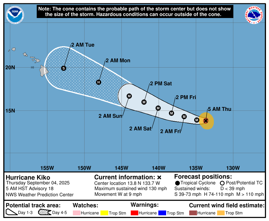
Maximum sustained winds has decreased and are near 125 mph and Kiko has been downgraded to a Category 3 hurricane on the Saffir-Simpson Hurricane Wind Scale.
According to forecasters, some strengthening is possible tonight and Friday, followed by slow weakening Friday night through the weekend.
Hurricane-force winds extend outward up to 25 miles from the center and tropical-storm-force winds extend outward up to 80 miles.
Swells generated by Hurricane Kiko could begin reaching the Hawaiian Islands towards the end of this weekend, according to the National Hurricane Center.
There are no coastal watches or warnings in effect at this time.
Update #3, 5 a.m., Sept. 4: Hurricane Kiko moved to about 1,470 miles east-southeast of Hilo as of 5 a.m. on Thursday, according to the National Hurricane Center.
While Kiko is a little weaker, it remains a Category 4 hurricane on the Saffir-Simpson Hurricane Wind Scale with maximum sustained winds near 130 mph and with higher gusts.
Forecasters said Kiko also could re-intensify as it continues westward well to the east-southeast of the Hawaiian Island.
Kiko currently is moving west at about 9 mph. This motion is expected to continue through Thursday night. On Friday, Kiko is expected to turn west-northwest and maintain this direction for the following few days.
Under the current forecast, Kiko would not begin to impact the Big Island until early Tuesday.
Fluctuations in intensity are expected in the next two to three days.
Hurricane-force winds extend outward up to 30 miles from the center and tropical storm-force winds extend outward up to 80 miles.
There are no coastal watches or warnings in effect at this time.
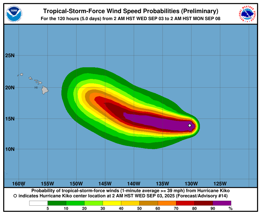
UPDATE #2, 11 a.m., Sept. 3: Hurricane Kiko is now a Category 4 storm.
Currently, it is 1,600 miles east of Hilo with winds of 130 miles per hour.
Some additional strengthening is possible over the next day or two, followed by fluctuations in intensity, the advisory indicates.
Hurricane-force winds extend outward up to 25 miles from the center and tropical-storm-force winds extend outward up to 80 miles.
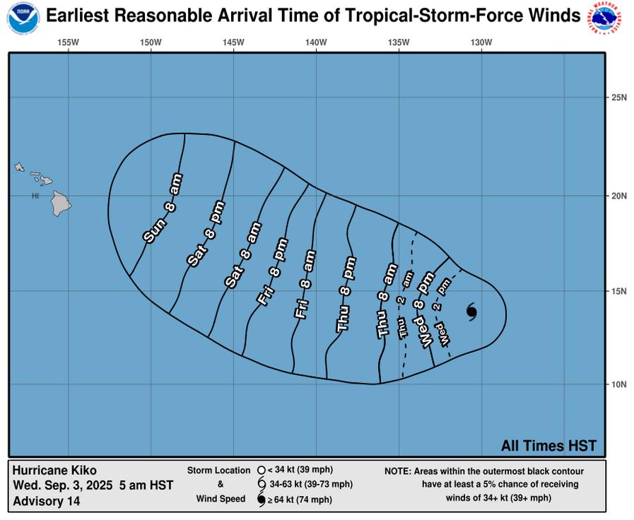
UPDATE # 1, 5 a.m., Sept. 3: Hurricane Kiko is expected to become a major hurricane later today, but it is now well east-southeast of the Hawaiian Islands, according to the National Hurricane Center.
As of the 5 a.m. weather advisory, Kiko was about 1,665 miles east of Hilo, traveling west at 7 mph.
Maximum sustained winds have increased to near 110 mph, with higher gusts. Some additional strengthening is forecast during the next 48 hours. Hurricane-force winds extend outward up to 15 miles from the center and tropical-storm-force winds extend outward up to 90 miles.
Kiko is expected to speed up slightly to 8 mph, heading west. This motion is expected to continue for the next few days with a gradual shift towards the west-northwest.
There are no coastal watches or warnings in effect.
ORIGINAL POST, Sept. 2, 2025:
Hurricane Kiko strengthens to Category 2 as it moves west about 1,740 miles east of Hilo.
The hurricane is intensifying in the general direction of Hawaiʻi and is expected to make a gradual turn toward the west-northwest late this week, according to the National Weather Service (NWS) forecasters in Honolulu.
As of 5 p.m. Tuesday, Sept. 2, Hurricane Kiko is moving at 7 mph with maximum sustained winds near 105 mph with higher gusts. Additional strengthening is expected during the next day or so, and it is forecast to become a major hurricane on Wednesday.
Hurricane-force winds extend outward up to 15 miles from the center, and tropical-storm-force winds extend outward up to 80 miles.
The story will be updated as more information comes in from the National Hurricane Center.

Sponsored Content


