‘Red Road’ Losing Its Namesake Hue
Editor’s Note: See related story, “Coastal Highway a ‘Visitors’ Paradise’ — Then and Now.”
According to Greek philosopher Heraclitus, there is nothing permanent except change.
And that is particularly true about Highway 137, a roadway traversing the picturesque Puna coast between Kapoho and Kalapana.
The road is better known to longtime residents as the “Red Road,” but that moniker will soon remain only in pictures and memories, as the final stretch of the roadway is receiving a fresh layer of asphalt. Of the black variety.
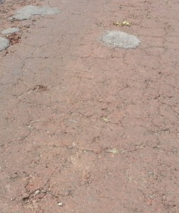
The Red Road earned its name from the rust-colored red cinder paving laid down in the early 1960s.
Area residents were such fans of its hue that some led a vocal revolt in the late 1990s when county officials announced plans to repave a 5-mile portion of it with regular asphalt.
Despite decades of patching with the darker stuff, and an uncontested repaving of a 6-mile stretch two years earlier, residents complained that covering the road’s characteristic color would result in a loss of the area’s identity.
The county tried to work out an asphaltic compromise.
Noting that modern environmental laws wouldn’t allow the use of the original recipe of red cinder aggregate and heavy bunker oil, it looked at several options, including adding red dye to the asphalt or giving it a light red-cinder dusting.
After determining those would be too costly, an agreement was reached at a well-attended public meeting calling for the road to be painted red, with the community providing the labor using county-supplied paint and rollers.
However, that never came to be as the manpower never materialized.
Priorities change, the main supporter of the paint project would say several years later.
The paving done in 2001 included adding ribbons of asphalt to widen narrow sections of the road, but some areas still have shoulder drop-offs which can make driving those sections an exercise in courtesy and patience.
The repaving work more than a decade ago left just the highway’s northernmost section still retaining its namesake color.
And even that will soon be no more.
The county is repaving the 2.3-mile section from Four Corners, the intersection of highways 137 and 132 in Kapoho, to the area of Ahalanui Park, also known as Hot Pond.
The $400,000 project being done by the county Department of Public Works is expected to be completed this week.
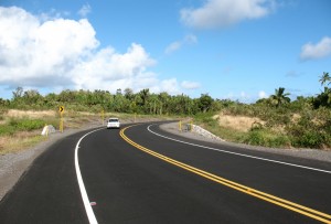
Over the past decade the Red Road has seen other improvements including three new loops bypassing areas threatened by ocean surges.
County officials said the bypasses were necessary because those stretches of roadway – as scenic as they were – were too close to harm’s way from flooding, high waves or the danger of collapse.

The bypasses, like this one around Isaac Kepo‘okalani Hale Memorial Park, add a definite modernity to the Red Road. Photo by Dave Smith.
The primary reason is the gradual sinking of the Puna coast, a process geologists call subsidence.
The entire Big Island is sinking, the result of the increasing weight of layer after layer of lava flows which causes a gradual bending of the lithosphere, the Earth’s outer layer consisting of the crust and upper mantle.
On average, the island is sinking at a rate of about a tenth of an inch annually.
Because of Kilauea’s activity the subsidence is more pronounced in Puna, where it also has been amplified by earthquakes.
During the 1975 Kalapana tremor, which at magnitude 7.2 was the strongest in the area in a century, the coast at Pohoiki dropped about 12 inches.
At Kaimu, a dozen miles further south, the shoreline sank three feet, forcing the raising of the road to keep high tides out of Harry K. Brown Park, the area’s most popular recreation spot before it was covered by lava nearly two decades ago.
The newest bypass goes around the newly refurbished Isaac Kepo‘okalani Hale (pronounced HA-lay) Memorial Park, named after the first Native Hawaiian to die in the Korean War.
At another, located just south of MacKenzie Park, the road was being undermined by waves. Indeed, county workers preparing for the bypass found old road striping along a guardrail, indicating that part of the road had been moved inward sometime in the past.
***UPDATE: Through the use of modernized measuring techniques, the Hawaiian Volcano Observatory in 2013 upgraded the magnitude of the 1975 Kalapana earthquake from 7.2 to 7.7.***


