


BLOG: Wednesday is Anniversary of Devastating 1960 Earthquake
***Updated on Tuesday, May 21, to note that the tsunami from the May 22, 1960 Chilean earthquake arrived in Hilo on May 23.***
By now, news has spread of an earthquake that struck off the coast of Chile last night.
The tremor that occurred at 11:49 p.m., Hawaii time, was initially reported to have a magnitude of 6.8, but the US Geological Survey later downgraded it to 6.5.
According to the Pacific Tsunami Warning Center, no significant tsunami was generated, probably because it was centered more than 350 miles off Chile’s coast.
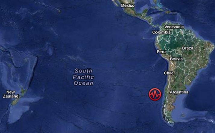
The location of last night’s earthquake 350 miles off the coast of Chile. USGS/Google Maps image.
In fact, the Christian Science Monitor reported that Chile’s naval seismology office said it was not felt on land.
But any earthquakes from that region quickly attract the attention of scientists and emergency managers alike, especially those in Hawaii.
That’s because they stir memories of what the USGS describes as “the largest earthquake in the world,” the massive 9.5-magnitude tremor that occurred 53 years ago this Wednesday.
The strongest earthquake ever recorded was the result of a piece of the Pacific seafloor the size of California sliding 50 feet below the continent of South America in the area of south-central Chile.
The result, according to later research by geophysicist Gerard Freyer of the tsunami warning center, was the offshore slopes of the continent snapping upwards 20 feet as the coast dropped 10 feet.
The tsunami that land movement generated killed 1,655 people worldwide and left 2 million homeless.
A series of eight waves hitting Hawaii 15 hours later, in the early morning hours of May 23, reached heights of 35 feet in Hilo Bay, with the biggest cresting 14 feet above sea level at the Wailuku River bridge.
The waves washed up to Kilauea-Keawe Street throughout the downtown area, and as far inland as Kekuanaoa Street, the road leading to the airport.
They left 61 people dead and damage estimated at $75 million.
The seismic hotbed along Chile’s coast – where the Nazca tectonic plate is sliding beneath South America at the rate of 23 feet per century – has produced three of the tremors on the USGS list of the world’s strongest earthquakes since 1900.
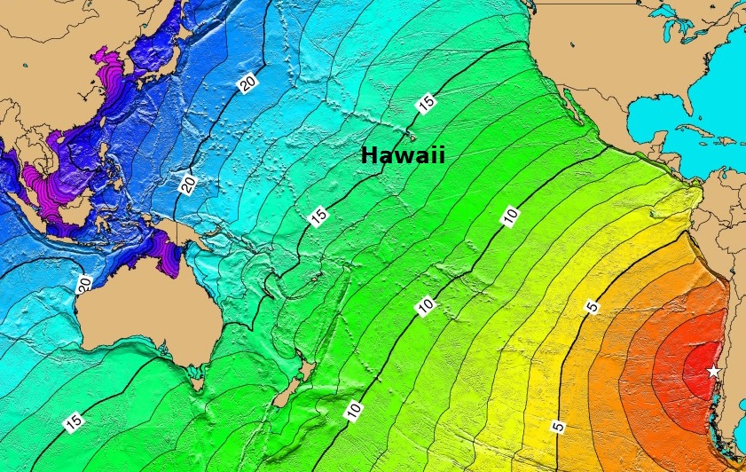
Tsunami travel times, in hours, for a tsunami generated off Chile. USGS map.
The other, a 2010 quake measuring a magnitude of 8.8, produced sea level changes of less than three feet in Hawaii. But the tsunami it generated locally killed 523 people in Chile, damaged or destroyed 370,000 homes and displaced 800,000 residents. Total economic loss in the nation was estimated at $30 billion.
According to the USGS, the coast of Chile has also been the source of six other earthquakes with a magnitude of 8.2 or greater since the 1700s.
One with a magnitude of 9.0 in 1868 washed out a bridge in Hilo and killed 25,000 people worldwide. Another of 8.2-magnitude in 1906 created a tsunami that had a wave run-up of 11 feet above sea level in Hawaii.
Tsnumami preparedness is the topic of a workshop Tuesday organized by the Pacific Tsunami Museum and the Hilo Downtown Improvement Association.
Sponsored Content


