


Volcano Watch: Watching volcanoes move, one survey at a time
“Volcano Watch” is a weekly article and activity update written by U.S. Geological Survey Hawaiian Volcano Observatory scientists and affiliates. Today’s column was written by University of Hawaiʻi Research Corporation geophysicist Brianna Corsa.
Hawaiian Volcano Observatory relies heavily on global positioning satellite data to monitor volcanic activity in Hawaiʻi.
Data collected are by a combination of permanent stations and annual surveys, giving scientists a picture of Mauna Loa’s changing shape through time.
In addition to a dense network of permanent GPS stations, providing daily positions, the observatory also conducts annual GPS surveys to collect high-precision data at benchmark locations around the island. The 2026 annual survey over Mauna Loa was recently completed.
Hawaiian Volcano Observatory has measured some of these benchmark locations for decades, first with survey techniques such as leveling and electronic distance measurement and then, starting in 1994, with GPS.
Mauna Loa erupted 34 times since 1843. It is the largest active volcano on Earth.
Its most recent eruption was from Nov. 27 to Dec. 10. Initial fissures opened within Mokuʻāweoweo, the summit caldera, and later Northeast Rift Zone vents produced lava flows that extended close to 12 miles and covered an area of about 16.5 square miles.
Given the volcano’s history of producing large, fast-moving lava flows, it is important Hawaiian Volcano Observatory continues to monitor ground deformation on various time scales to understand its behavior.
Data from the recent GPS survey increases spatial coverage of the the observatory’s geodetic network and improves our understanding of the long-term deformation field of Mauna Loa, including how the surface changes in response to magma accumulation or migration below the ground surface.
For example, motions away from a volcano’s summit might indicate inflation, growth or rise of the magma reservoir. GPS positions pointing inward suggest deflation or migration of magma away from a region.
Patterns of deformation help prepare scientists for potential hazards, which in turn allows for effective communication of hazards to nearby communities and time for safety efforts to take place.
Benchmarks that remain relatively stable through time provide important and reliable ground control points for mapping, calibrating imagery, validating models and a variety of other research endeavors.
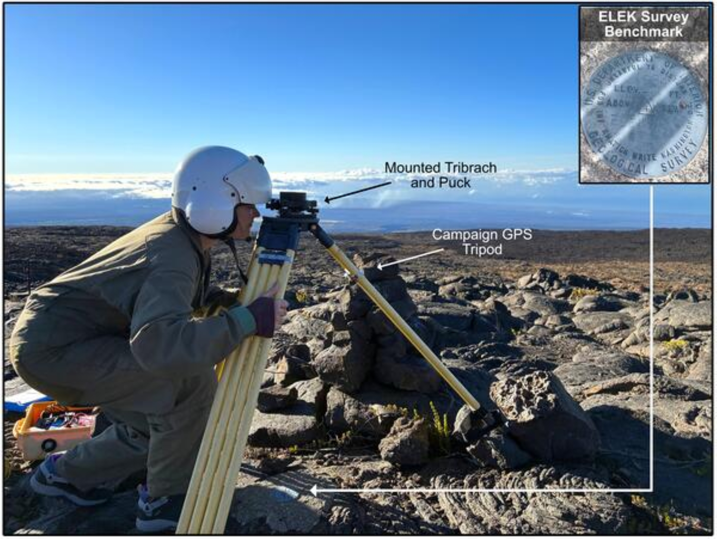
There were 22 benchmarks surveyed this year on Mauna Loa, requiring a staged deployment during several days. Each survey set-up consists of a GPS antenna that receives the signals from the satellite, GPS receiver that records the incoming data and a tripod, tribrach with an optical plummet and mounting puck that positions the antenna precisely over the benchmark.
Because we are trying to measure positions with accuracy to a fraction of an inch, it is crucial the equipment is carefully set up, which can be challenging on varied terrain such as lava flows!
This means it is important the antenna is precisely aligned over the benchmark, level and oriented toward north. The optical plummet in the tribrach allows us to sight down to the benchmark and make adjustments needed to center the antenna.
Instruments record data for 3 to 5 days before the team returns to collect the equipment and redeploy them with fresh batteries at the next benchmark locations. This window of time is needed for the specialized data processing we use to produce precise positions.
It also allows for certain measurement uncertainties to be resolved and reduces errors because of atmospheric effects.
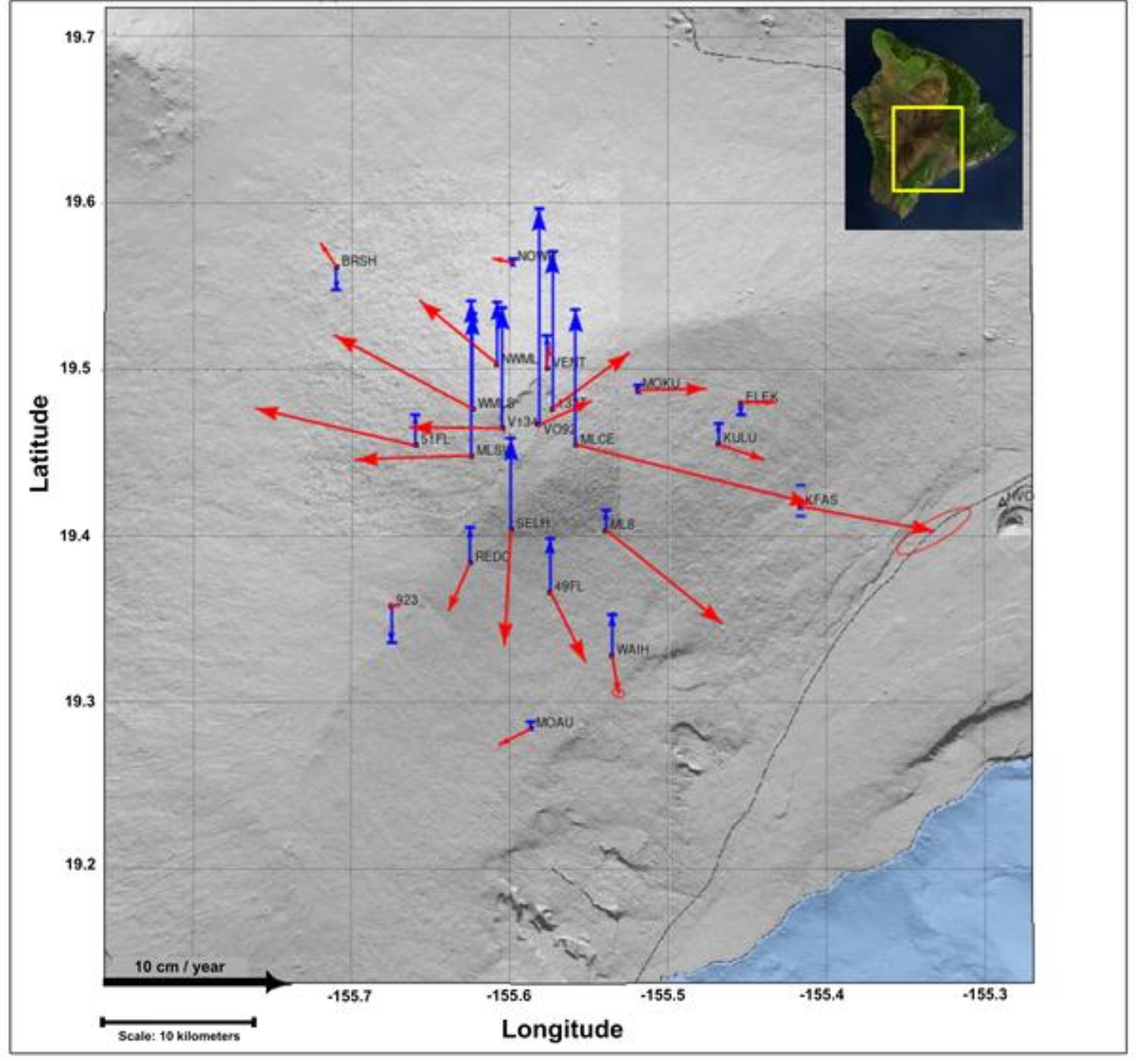
This year’s survey results align well with trends from the past 10+ years.
All benchmarks around the summit moved up and away from their original locations while several stations on the volcano’s flanks moved slightly down and away.
Average rate of ground motion at the summit from 2025 to 2026 is about 2.9 inches per year, consistent with rates from past surveys and those measured at permanent GPS stations from after the 2022 eruption (see “Volcano Watch” from Feb. 26).
While Mauna Loa continues to slowly accumulate magma below the surface, seismicity and gas emissions at Mauna Loa’s summit remained at low, steady levels during the same period, indicating an eruption is not expected in the immediate future.
Nevertheless, Hawaiian Volcano Observatory scientists continuously monitor deformation to detect subtle changes in activity to provide Hawaiʻi residents with the earliest possible warning of renewed unrest.
* * * * * * * * *
VOLCANO ACTIVITY UPDATES
KĪLAUEA volcano
VOLCANO ALERT LEVEL: Advisory
Kīlauea has been erupting episodically since Dec. 23, 2024, within the summit caldera. Episode 51 of summit lava fountaining happened for about 8 hours July 15. No unusual activity has been noted along Kīlauea’s East Rift Zone or Southwest Rift Zone.
WHAT’S NEXT: Summit region inflation since the end of Episode 51 indicates another lava fountaining episode is possible, with current models indicating it could begin between July 25 and 29.
MAUNA LOA volcano
VOLCANO ALERT LEVEL: Normal
Mauna Loa is not erupting. Learn more about what’s happening at — and under — the volcano in the most recent Hawaiian Volcano Observatory monthly activity report issued July 2.
Hawaiian Volcano Observatory continues to closely monitor Kīlauea and Mauna Loa.
* * * * * * * * *
EARTHQUAKE UPDATES
No earthquakes were reported felt during the past week throughout the Hawaiian Islands.
Visit the Hawaiian Volcano Observatory website for past “Volcano Watch” articles, Kīlauea and Mauna Loa updates, volcano photos, maps, recent earthquake information and more. Email questions to askHVO@usgs.gov.





