

‘Kona Low 2: The Sequel’: Heavy rain, thunderstorms still possible for Big Island
The most anticipated event of last week didn’t arrive on the Big Island until after an already action-packed premiere weekend elsewhere in the island chain, so there was some confusion about if the island would still be part of its planned statewide rollout.
“Kona Low 2: The Sequel” finally reached Hawai’i County shores late Sunday afternoon and early evening March 22, albeit a deflated version of itself following dangerous, catastrophic performances already on O’ahu and in Maui County.
Second in back-to-back cold-core sutropical cyclones that slammed into the state during the past 2 weeks, forecasters at the National Weather Service office in Honolulu sill expected this week’s kona low to make quite a bit more than a splash after it got here.
“We expect Big Island to experience more rainfall in the short-term than what was experienced during the past 24 hours,” said Honolulu forecast office meteorologist Derek Wroe on Sunday. “Heavy rainfall and thunderstorms will be possible into Monday [March 23].”
Wroe added a threat of flooding continues as the storm moves over the Big Island despite rainfall estimates being much less than those for O’ahu and Maui County — both of which experienced extreme, dangerous, catastrophic flooding caused by the second kona low.
“Our kona low is weakening and moving off to the northeast today, with the heavy rain band weakening as it moves over us,” said citizen meteorologist and administrator of Facebook group Puna Weather Harry Durgin in his Sunday daily forecast post. “Despite the weakening trend, deep tropical moisture remains in place, as well as colder air aloft. As such, downpours and thunder are still possible through Monday.”
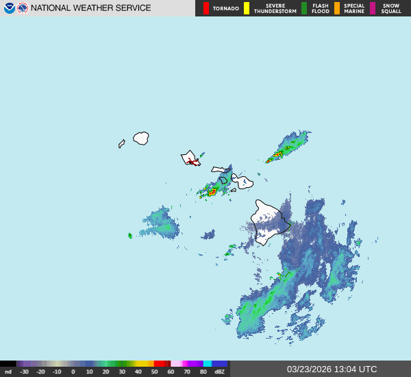
The National Weather Service risk outlook issued Sunday morning by the Honolulu forecast office showed a minor risk for possible flash flooding and isolated thunderstorms through Sunday.
A flood watch in effect for the Big Island also was extended first Sunday evening until 6 a.m. Monday and then again early Monday morning until 6 p.m. the same day because of moisture left from the departing kona low and a trough aloft that will continue to make heavy rain and thunderstorms possible throughout the day.
The Big Island is the only part of the state where a flood watch remains in effect.
“A large band of thunderstorms continues to approach the Big Island from the west-southwest direction, which may produce another round of heavy rainfall later today,” forecasters said in their new advisory.
Already saturated grounds because of the heavy rainfall and flooding around the island during the first kona low now a bit more than a week ago also increases the risk of flooding and flash flooding.
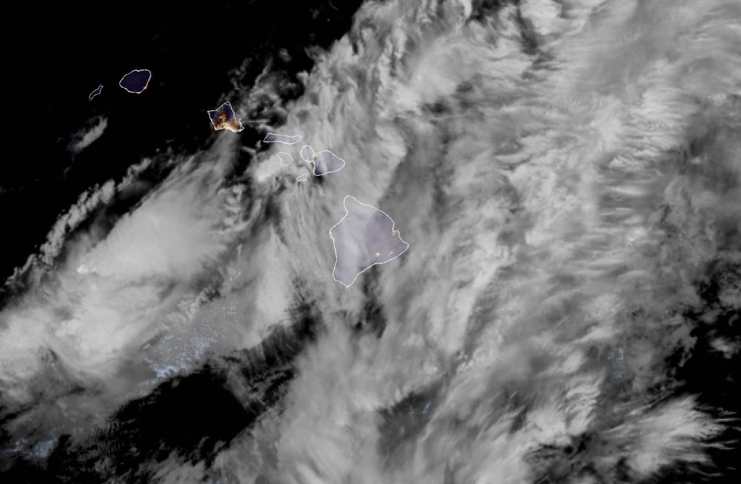
The National Weather Service area forecast discussion at about 9 p.m. Sunday reported that bands of moderate to heavy rain showers and a few thunderstorms continued to develop over coastal waters near the Big Island.
“These developing shower bands may continue to produce some additional rainfall over the Big Island through Monday morning,” said the forecast.
The latest short-range models show the frequency of those developing shower bands will decline Monday as stabilizing trade winds spread southeastward to all islands by Monday afternoon.
A winter storm warning for the summits of Mauna Kea and Mauna Loa above 12,000 feet also was extended Sunday night through Monday morning but then canceled at about 2:30 a.m. Monday, more than 3 hours before it was set to expire, because the threat for impactful winter weather had ended.
A minor risk of numerous convective showers exists through Monday, according to the National Weather Service weather risk outlook from Sunday morning, with usual trade wind weather returning by Tuesday, March 24.
“Windward showers will initially be scattered to numerous Monday, but will decrease to a more typical trade wind regime with isolated to scattered showers across windward and mauka areas,” the area forecast discussion said.
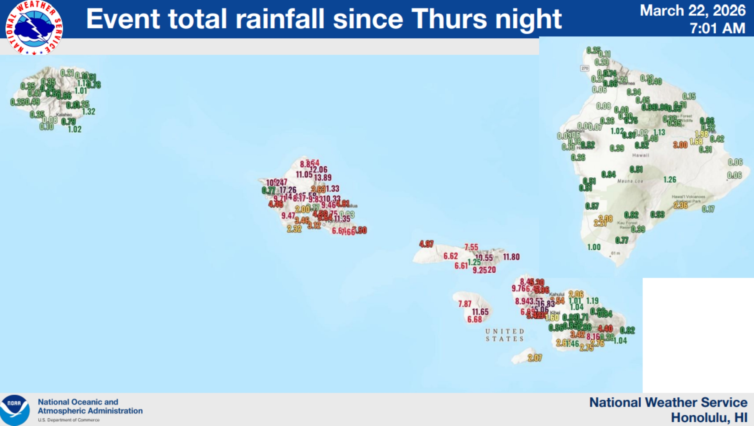
Rainfall totals ranged from 0.01 of an inch up to nearly 2.97 inches between Saturday and Sunday. Two other rain gauges collected more than 2 inches and five others recorded between 1 and 2 inches of rain.
Event total rainfall amounts measured around the Big Island from when the second kona low started moving down the island chain Thursday, March 19, through Sunday ranged from 0.02 of an inch up to 3 inches.
Three gauges collecting between 2 and 2.99 inches with five rain gauges recording between 1 and 1.99 inches of rain. Another five gauges collected between 0.8 and 0.99 of an inch, too.
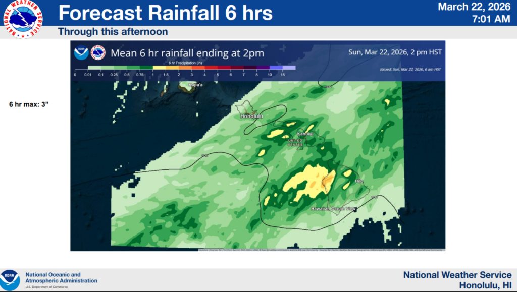
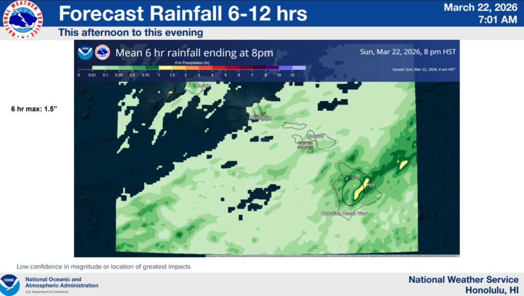
The morning National Weather Service briefing estimated the maximum amount of rain to fall anywhere in the state throughout a 6-hour period ending at 2 p.m. Sunday was 3 inches. The maximum amount for the next 6 hours through 8 p.m. was estimated at 1.5 inches, with an estimated maximum of 0.5 of an inch during the next 6-hour period ending at 2 a.m. Monday.
 Rainfall estimates through 2 p.m. Sunday, March 22, 2026. (Graphic Courtesy: National Weather Service Honolulu forecast office)
- Six to 12 hour rainfall estimates through 8 p.m. Sunday, March 22, 2026. (Graphic Courtesy: National Weather Service Honolulu forecast office)
- Rainfall estimates for 12 to 18 hour period ending at 2 a.m. Monday, March 23, 2026. (Graphic Courtesy: National Weather Service Honolulu forecast office)
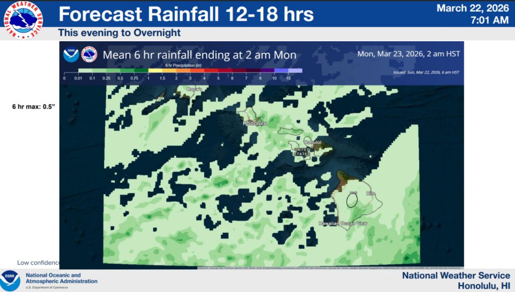
That would be a total of up to 5 inches maximum estimated to fall during the 18-hour period ending at 2 a.m. Monday.
TOP 24-HOUR RAINFALL TOTALS
Ending 9 p.m. March 22, measured in inches, and reporting rain gauges
HAWAI‘I ISLAND
- Pali 2 (RAWS): 2.31
- Kona Hema (UHM): 2.19
- Kahuku Ranch (RAWS): 1.97
KAUA‘I
- Kilohana (USGS): 1.24
- Makaha Ridge (RAWS): 0.31
- Waipā (UHM: 0.18
LĀNAʻI
- Lānaʻi City (14012): 2.38
- Lānaʻi Airport (ASOS): 1.25
- Lānaʻi 1 (RAWS): 0.94
MAUI
- Hanaʻula (UHM): 2.60
- Puʻu Kukui (USGS): 2.29
- Waikapū Country Club (14005): 1.89
MOLOKA‘I
- Keōpukaloa (UHM): 9.89
- Honolimaloo (UHM): 8.22
- Makapulapai (RAWS): 7.29
O‘AHU
- St. Stephens (13006): 1.58
- Niu Valley (13001): 1.43
- Kalawahine (UHM): 1.33
DATA: National Weather Service Honolulu forecast office
- Hawaiʻi County Civil Defense and other officials gather after activating this past weekend to keep watch as the second of back-to-back kona lows moved toward the Big Island. (Screenshot from Video: Courtesy of Hawaiʻi County Mayor Kimo Alameda’s social media)
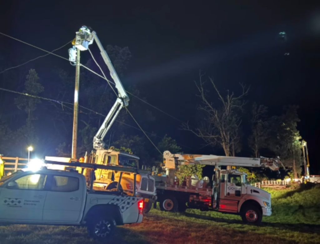
- Hawaiian Electric crews work to restore power to Big Island customers experiencing outages following the first of back-to-back kona low storms to impact the island. (Screenshot from Video: Courtesy of Hawaiʻi County Mayor Kimo Alameda’s social media)


This second of the back-to-back kona lows to move through the state came about a week after the first.
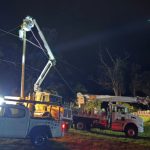
The much more powerful predecessor flooded the state with a deluge of damaging, destructive drama and literally blew the roof off at least one building, with Maui County and Hawai‘i Island on the VIP list to experience its full force.
Repeated rounds of heavy rain fell over the state from March 11-15, starting with Kaua‘i at the northwest end of the island chain then drawing up deep tropical moisture from the south that moved southwest though the state.
Rainfall of 15 to 25 inches was collected in areas along southeastern portions of Maui and the Big Island, with locally higher amounts of 30 or more inches of rain. The first kona low super soaked the state, especially the southeastern half.
Nearly 50 inches of rain fell at the Summit (UHM) rain gauge site near the summit of Haleakalā on Maui. Another nearly 50 inches of rain, only slightly less than the summit rain gauge, was collected by the Kula 1 gauge on the Valley Isle.
The Puʻu Waʻawaʻa (UHM) rain gauge reported nearly 39 inches of rainfall during the first kona low from its location atop Puʻu Waʻawaʻa Cinder Cone in the Puʻu Waʻawaʻa Forest Reserve on the Big Island’s Mauna Kea. Nāhuku (UHM) gauge collected just more than 34 inches at its Nāhuku Lava Tube location inside Hawai’i Volcanoes National Park on the Big Island.
That storm also produced very strong south to southwesterly winds with damaging wind gusts in the 60 to 75 mph range. At higher elevations, locally stronger gusts that exceeded 100 mph happened at Puʻu Waʻawaʻa and atop the Mauna Kea summit on the Big Island.
Southern portions of Maui and the Big Island were among the areas that took the brunt force trauma served up the first kona low. Impacts included numerous road closures and even washed out roadways from locally heavy downpours and overflowing streams, as well as significant flooding of homes and businesses, swift water rescues and landslides.
Wind impacts included countless power outages — some of which only were corrected as the second kona low started to wreak its own havoc throughout the state — because of hundreds of downed trees and power lines, as well as roof and other structural damages, including the roof at HappiNess Kona restaurant on Ali‘i Drive in Kailua-Kona.
Wroe said the first kona low was large and well-organized.
“Forecast models perform much better with details when systems are well-organized,” he said.
The second storm focused on O‘ahu and Maui County, almost as if it wanted to punch right through the center of the state.
Winds weren’t as strong, and the kona low from March 19-23 poured a maximum of just more than 17 inches in one location on O‘ahu and nearly the same amount in a location in Maui County that also was the maximum rainfall there, too.
Already saturated grounds combined with more than originally forecast and expected rain along areas of O‘ahu’s North Shore and northwest portions of Maui led to what many have called historic and catastrophic flooding, causing thousands on both islands to be evacuated and hundreds of rescues March 20-21.
Some of the hardest hit places included Haleiwa and Waialua on O‘ahu’s North Shore and Molokaʻi, Lahaina, Kīhei, ʻĪao Valley and Wailuku in Maui County. Damages in some areas impacted by ferocious flooding were described as total losses.
It might seem as though the Big Island could miss out on even more destruction as the second kona low moves away from the islands today after only 2 to 3 inches of rain falling in just a few places on the island since last Thursday.
But as meteorologists and government officials said since prior to the first kona low struck, it’s always better to be vigilant and prepared in the event something changes.
A post on Howzit Kohala from Friday on Facebook said the second storm already created havoc on O‘ahu and it was still expected to impact the Big Island. The author added that the storm is unpredictable; there wasn’t strong consensus on its path or strength.
“This system lacked significant organization,” Wroe said Sunday afternoon, adding especially the tail end of the system — the part that is suppose to impact the Big Island before moving away from the state — being “not very organized” at all. “Quite a bit of moisture will remain pooled around Big Island, while a weakening upper level disturbance provides instability. These ingredients tend to produce areas of heavy rainfall and thunderstorms that are difficult to predict with precision.”
So the best advice: don’t let your guard down until you know for sure it’s over.
No one wants to add to storm damages Hawai‘i Gov. Josh Green said at the end of last week could top $1 billion.
“Neighbor islands, especially O‘ahu, have already been severely impacted, and Hawai‘i Island is right along the edge of the severe weather which means we’re still at risk,” said Hawai‘i County Mayor Kimo Alameda in his weekly update Friday. “And because of our grounds are already saturated, alright, the weather risk is sort of ‘all or nothing.’ In other words, if it comes, it’s going to be a big problem again.”
The mayor said this second round of severe weather, if it materialized, would likely not be to the same degree that the island received the week prior, but “we still gotta be prepared,” so Hawai‘i County Civil Defense was activated and emergency management as well as top county officials kept a close eye on the weather throughout the weekend.
“So stay prepared and stay connected to our media messaging,” Alameda said.

There’s always a silver lining around some of the darkest storm clouds, too.
If we can get through this last bit of the storm, Wroe said the outlook shows no further kona lows or other severe weather in the near future.
“It appears that we will enter a more benign weather phase, once the flood threat diminishes over the next day or so,” he said. “We do not see a significant threat for the next week and half. Beyond that, it is difficult to predict.”
Sponsored Content


