

VIDEO, PHOTOS: Overflight of Leilani Estates
VC: Mick Kalber at 6 a.m. Sunday morning, May 6, 2018.
Paradise Helicopters conducted and overflight of the Leilani Estates Subdivision on Sunday, May 6 at 6 a.m.
“The east side of the Big Island—the Puna District—is literally being ripped apart,” said Mick Kalber, Paradise Helicopters’ videographer.
Sunday morning’s fissure eruption was by far the largest the crew has seen so far, starting just above Luana Street and crossing Leilani Avenue.
“Lava poured into a group of homes to the north,” Kalber said.
“Generally, these fissure outbreaks have begun violently, and quit quickly, but this one appears to be an exception,” Kalber said. “The fountains were carrying lava over 200 feet into the air in a spectacular display.”
In the 40 minutes the crew was overhead, the witnessed the destruction of two homes, and there were any number of others in close proximity.
USGS Report From May 6, 2018
Lower East Rift Zone Eruption
The intermittent eruption of lava in the Leilani Estates subdivision in the lower East Rift Zone of Kīlauea Volcano continues. Fissure 7 stopped erupting in mid-afternoon. A new fissure erupted this evening near fissures 2 and 7, and lava fountains reached as high as about 230 feet. Early in the morning, new ground cracks were reported on Highway 130, but no heat or escaping steam was subsequently observed.
Seismicity and deformation are consistent with continued accumulation of magma within the rift zone.
Residents should remain informed and heed Hawaii County Civil Defense closures, warnings, and messages (http://www.hawaiicounty.gov/active-alerts).
For maps showing the locations of eruption features: https://volcanoes.usgs.gov/volcanoes/kilauea/multimedia_maps.html
For information on volcanic air pollution, http://www.ivhhn.org/vog/
HVO geologists will be in the area overnight to track and report to Hawaii County Civil Defense on the activity, and other scientists are closely tracking the volcano’s overall activity using various monitoring data streams.
Kīlauea Volcano Summit
Tiltmeters at the summit of Kīlauea Volcano continue to record the deflationary trend of the past several days. Satellite InSAR data show that between April 23 and May 5, 2018, the summit caldera floor subsided about 4 inches. Corresponding to this deflationary trend, the summit lava lake level in Overlook crater has dropped about 518 feet below the crater rim since April 30. Rockfalls from the crater walls into the retreating lake produced ashy plumes above Halemaumau crater, resulting in light ashfall in the summit area. Rockfalls and ashy plumes are expected to continue as the lake level drops.
Earthquake activity in the summit increased in the past two days, coincident with the magnitude-6.9 earthquake on May 4 beneath the south flank of Kīlauea. In the past two days (May 5 and 6), about 152 magnitude-2 and magnitude-3 earthquakes occurred at depths less than 3 miles beneath the summit area. Twenty two magnitude-3 earthquakes were recorded. These earthquakes are related to the ongoing subsidence of the summit area and beneath the south flank of the volcano.

A view of the fissures, facing east, all lining up with the eastern tip of the island, Cape Kumakahi. PC: Mick Kalber at 6 a.m. Sunday, May 6, 2018.
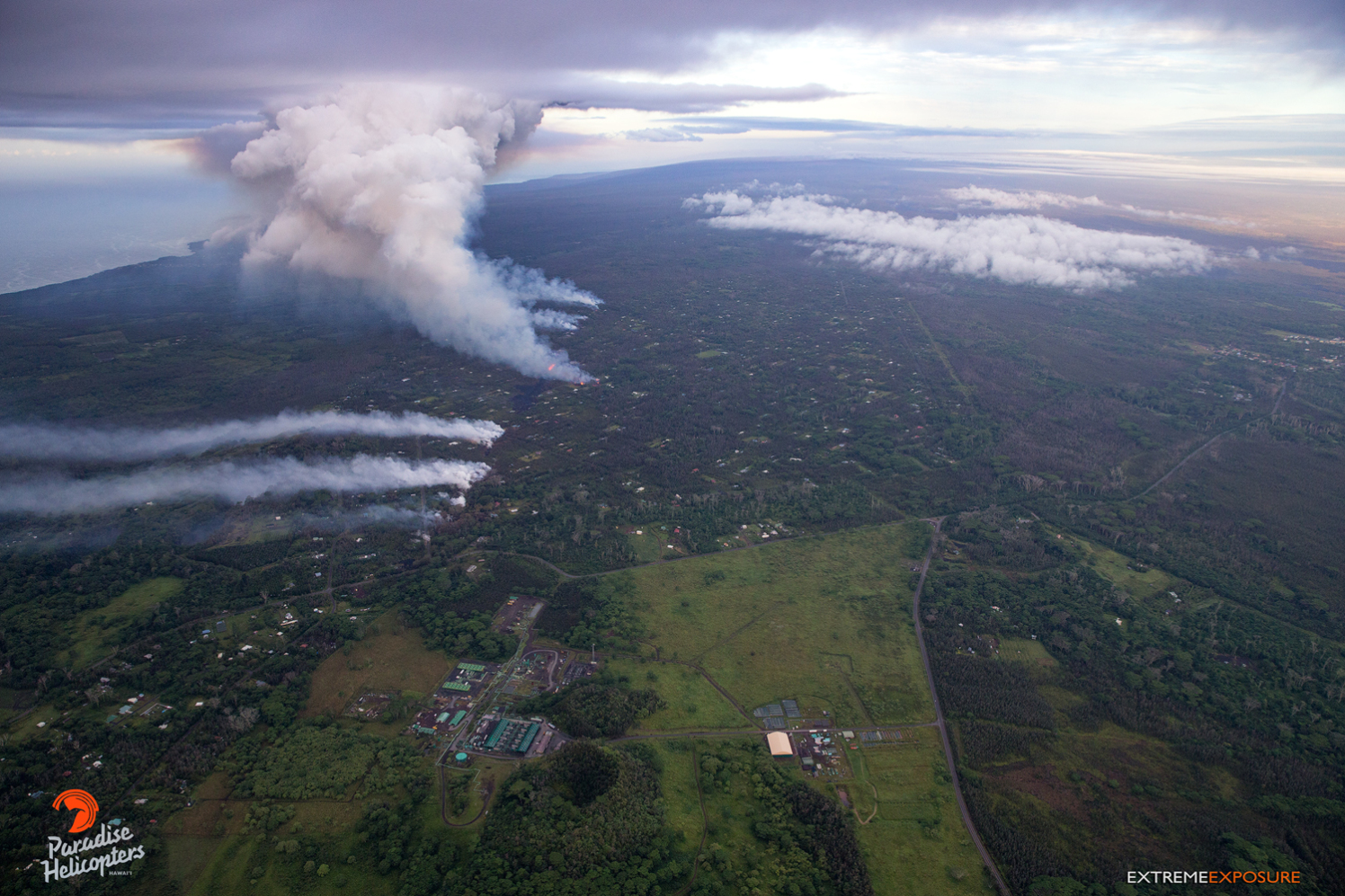
A view looking southwest. Puna Geothermal Verture’s facility sits in the lower left middle of the frame. PC: Mick Kalber at 6 a.m. Sunday, May 6, 2018.

Plumes of toxic gas rise from each of the fissures that have formed, blowing to the coast. PC: Mick Kalber at 6 a.m. Sunday, May 6, 2018.

Another angle of the fissure eruption. PC: Mick Kalber at 6 a.m. Sunday, May 6, 2018.
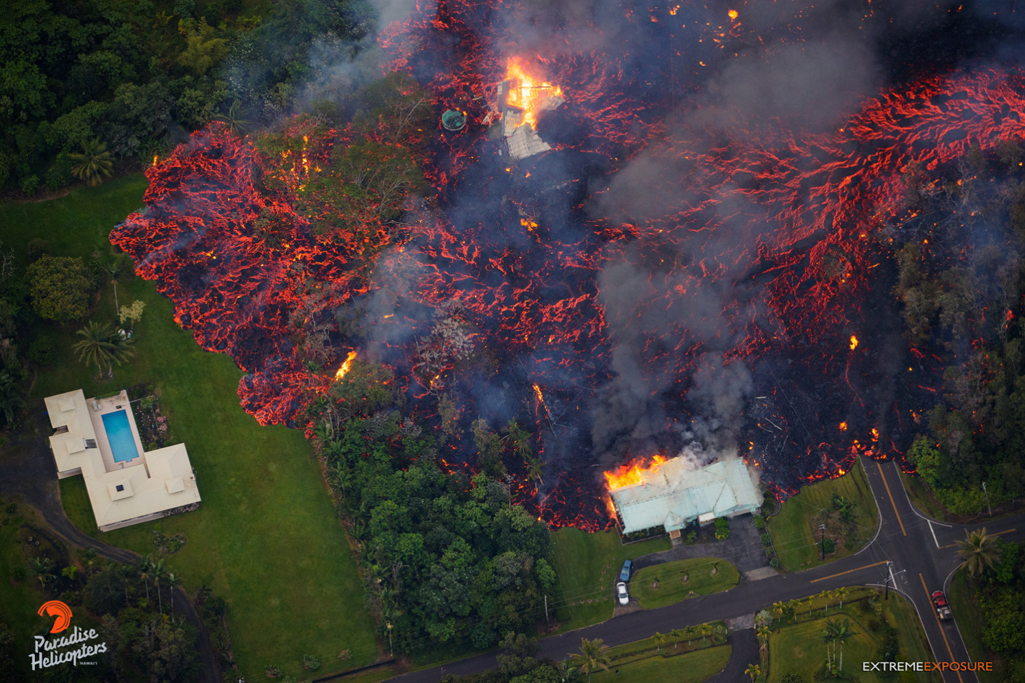
Kilauea’s east rift zone overflight: Two homes are consumed by the massive flow, and a third is threatened, as the lava advances downslope. PC: Mick Kalber at 6 a.m. Sunday, May 6, 2018.

Kilauea’s east rift zone overflight: Robust fountains of lava shoot skyward from the fissure. PC: Mick Kalber at 6 a.m. Sunday, May 6, 2018.

May 6, 2018, 6:00 am – Kilauea’s east rift zone overflight: A massive flow pours into a yard, surrounding trunks of trees, eventually charring through their trunks and eventually toppling them. PC: Mick Kalber at 6 a.m. Sunday, May 6, 2018.

200′ high fountains fed massive flows that consumed homes and covered property… Such a tough thing to shoot, as me heart breaks every time I see a home get taken. Prayers for Leilani Estates homeowners, and all those affected. PC: Mick Kalber at 6 a.m. Sunday, May 6, 2018.

A substantial fissure eruption hosted 200′ fountains that fed massive flows that consumed everything that lay in their paths. PC: Mick Kalber at 6 a.m. Sunday, May 6, 2018.
Sponsored Content


