

The weather theme for Hawaiʻi in August is ‘dry, drier and driest’
Most of Hawaiʻi Island was below average rainfall for August, with the seasonable exception of the leeward coast/slopes of the Kohala and Kona districts which turned in another month with many sites near to above average, according to the National Weather Service.
Ten stations on the Big Island recorded the driest August on record, including the station at Hilo International Airport that began keeping rain gauge data in 1949.
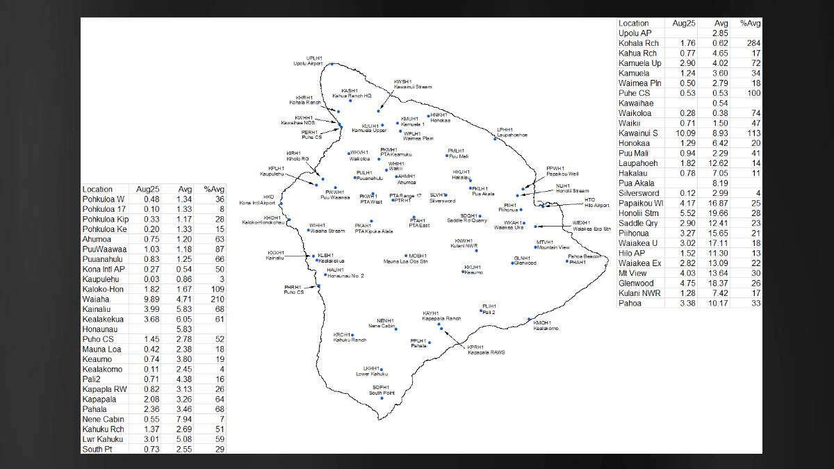
The driest areas of the island were the higher elevations of the interior, alongside the rest of the Kaʻū and Hāmākua districts, failing to exceed 25% of their August rainfall averages. The windward coasts of the Hilo and Puna districts also struggled to reach approximately 30% of the average.
The highest monthly and daily rainfall total recorded by the U.S. Geological Survey on the Big Island occurred at Kawainui Stream at 10.09 inches, which is 113% higher than its average.
The majority of the state reported below-average rainfall totals for the month, except for a few modest rainfall events that helped a few sites reach average or above.
On Aug. 6, humid conditions developed as the remnants of Tropical Cyclone Gil passed north of the islands, disrupting the trades and allowing land and sea breezes. The moisture brought 0.25 to 0.5 inches of rain over windward and some leeward slopes, including up to 0.3 inches in Kaʻū, which has been affected by drought.
Trades and drier weather returned until Tropical Cyclone Henriette passed north, bringing light winds, humid conditions, and only isolated showers on Aug. 10 and 11.
Moderate to breezy trades resumed from Aug. 12 to 24, with lower humidity and limited windward showers.
Between Aug. 25 and 27, a stalled surface low north of the islands created a hybrid pattern of east-southeast trades and land/sea breezes. This produced showers along east- and southeast-facing slopes of Hawaiʻi Island, while the rest of the state remained mostly dry.
From Aug. 28 to 31, another trough kept winds light to moderate with leeward sea breezes. The Kona coast saw the most rain to start, with 0.25 to 1 inch on Aug. 28 and 0.75 to 1 inch on Aug. 29.
A surge of deep tropical moisture, associated with a trough passing just south of the islands on the 30th and 31st, increased showers statewide, bringing 0.33 to 0.75 inches to windward terrains on Hawaiʻi Island, Kauaʻi, Maui, and Oʻahu, with over 1 inch in the Koʻolau Mountains.
Sponsored Content

_1770333123096.webp)

