

Strong winds persist in driest areas of Big Island, continuing elevated wildfire danger
The National Weather Service in Honolulu extended its wind advisory to Tuesday at 6 p.m. for North Kohala and portions of South Kohala, North Kona, Hāmākua, Kaʻū and Puna on the Big Island.
The forecast calls for strong trade winds of 20 to 30 mph, gusting up to about 50 mph, with winds even expected to slightly strengthen through the rest of today and peak later today and tonight.
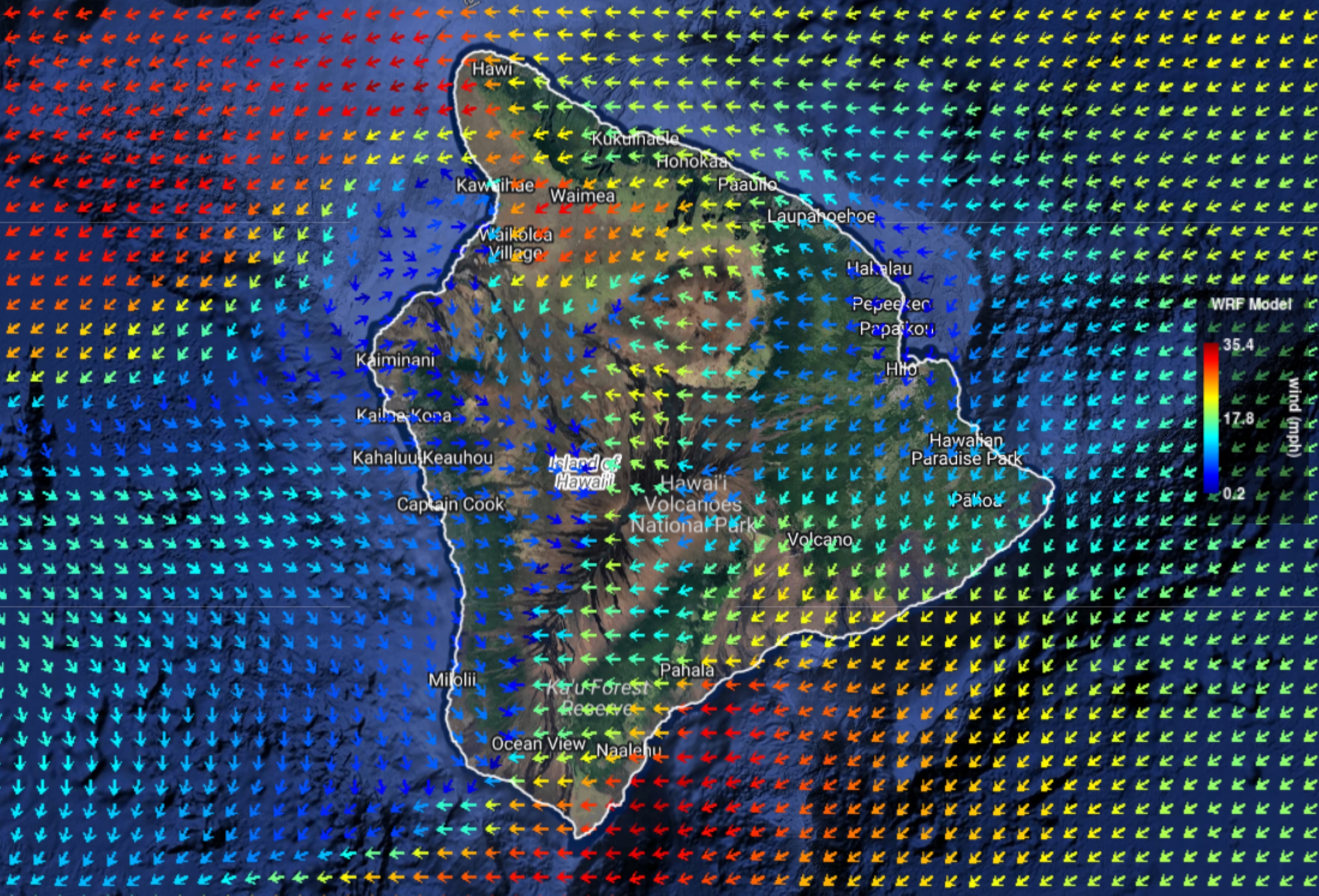
The summits of Mauna Kea and Mauna Loa are now also targets of the strong high pressure ridge north of the state causing the wind advisory conditions, with blustery sustained winds of 35 to 50 mph forecast and gusts up to 60 mph.
With the high winds, hazards include: shingles blowing off homes, falling tree branches and other objects flying through the air. Plus, strong winds can make driving difficult, especially in high-profile vehicles and definitely at the summits, as well as power outages being a possibility.
Wildfire danger also is significantly elevated in the wind advisory — and driest — areas of the island.
Temperature inversion heights range from 6,000 to 7,000 feet today, but are forecast to fall to 5,000 to 6,000 feet Tuesday, making winds become gusty over and downwind of the island’s mountains.
Inversion level indicates the depth of a stable airmass from the ground. The lower the inversion level, the more air below is compressed and moves faster. So when warm, dry air is trapped underneath, the risk of fire spread increases.
An abundance of available fuel to burn with very dry vegetation in drought-stricken areas adds to a real risk of near or true critical fire weather conditions for parched leeward areas.
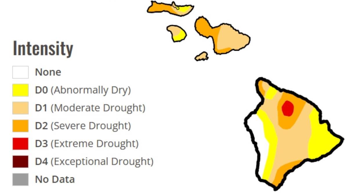
Nearly 90% of the Big Island is abnormally dry or under drought, according to U.S. Drought Monitor data as of July 1, including all of the areas covered by the wind advisory, with Hāmākua — a portion of which under extreme drought — seeing some of the worst conditions.

Hawai‘i County Civil Defense on Sunday afternoon urged the public in those areas to exercise caution when planning and having outside activities — especially when fire is involved.
“Be careful with the use of open flame and fire and hotwork activity,” Civil Defense said in an early afternoon message. “Please avoid parking vehicles on dry grass after travel.”
Hawaiian Electric continues to closely monitor the weather in areas of Maui and Hawai‘i counties at higher threat of wildfire. It could proactively shut power off in those communities through its Public Safety Power Shutoff Program if weather conditions again intensify.
Maps of specific areas on each island that have high wildfire risk and could be subject to a Public Safety Power Shutoff can be found on Hawaiian Electric’s website.
South Point recorded a maximum sustained wind of 29 mph at just after 11 a.m. Sunday, with its strongest wind gust of 40 mph howling just after 7 p.m. across the cliffs at the point and green sands of Papakōlea Beach.
Sustained wind speeds trended consistently from 20 to 29 mph between just after 5 a.m. and 10 p.m., gusting between 30 and 40 mph during the same period.
A little more than 98 miles to the north in Kawaihae, a maximum wind speed of 26 mph was recorded at 9:30 a.m. today, making it the strongest wind to blow during the past 24 hours in the South Kohala community.
Kawaihae’s maximum wind gust of 37 mph during the same period was recorded at the same time.
Some of the strongest winds in Kawaihae blew Sunday morning, with sustained winds trending more than 20 mph for several hours.
Drive about 12 miles slightly south but mostly east and you’ll find Waimea and the nearby Puhe CS remote automatic weather station, which as of this morning reported a 24-hour maximum sustained wind speed of 17 mph recorded at 9:24 a.m. Sunday, with a maximum wind gust of 40 mph recorded at the same time.
The automated weather station reported gusts just less than that during the next couple of hours, recording its highest winds so far through the early morning and before noon Sunday.
Despite the elevated threat of wildfire, however, the National Weather Service does not expect to issue any fire weather-related watches or warnings.
Trade wind speeds are expected to begin decreasing by Wednesday. That trend should continue through the rest of the week, with winds becoming more moderate by this weekend.
Call Hawaiian Electric’s Public Safety Power Shutoff toll-free hotline at 1-844-483-8666 or click here to get additional information about the program.
Check the Hawaiʻi County Hazard Impact Map for information about hazards or emergencies and any associated road closures, shelters, evacuations and more.
Get the latest forecast and information about weather advisories, watches or warnings by visiting the National Weather Service Honolulu forecast office website.
Sponsored Content


