

11 p.m. UPDATE: Ignacio Expected to Rapidly Weaken
***Updated at 11:04 p.m. to include information from the Central Pacific Hurricane Center.***
By Meteorologist Malika Dudley
Hurricane Ignacio is still a major category three hurricane with winds at 115 mph. Rapid weakening is expected through Monday with a slower weakening trend through Tuesday.
Hurricane force winds extend 45 miles from the center, while tropical storm force winds extend up to 175 miles from the center of Ignacio.
The system is expected to pass east and northeast of Hawaii over the next couple of days and is currently moving northwest near 9 mph.
The CPHC says total rainfall amounts of 1 to 4 inches, with isolated amounts near 5 inches mainly in areas of higher terrain, are possible. Swells generated by Ignacio will increase along east and southeast facing shores of the Big Island and Maui County and will result in elevated surf heights through Tuesday. The high surf is expected to create dangerous currents. High winds are no longer expected.
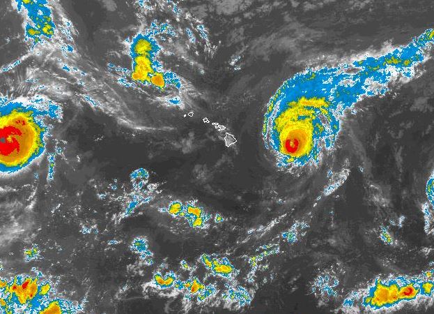
National Hurricane Center image, as of 11 p.m.
Meanwhile, hurricane Jimena is moving west-northwest near 17 mph and expected to slow down over the next couple of days. Maximum sustained winds are near 150 mph making the system a category 4 hurricane. Only slow weakening is forecast over the next 48 hours. Hurricane force winds extend outward up to 60 miles, while tropical storm force winds extend up to 175 miles from the center.
***Updated at 5:15 p.m. to include information from the Central Pacific Hurricane Center.***
By: Jamilia Epping
The Tropical Storm Watch for the Big Island and Maui County has been dropped, as of the Central Pacific Hurricane Center’s 5 p.m. advisory.
Hurricane Ignacio was located 355 miles east of Hilo and moving to the northwest at 12 miles per hour. The storm is still classified as a Category 3 hurricane with maximum sustained winds of 115 mph.
CPHC forecasts that the biggest impact that Hurricane Ignacio will have on the island will be surf related. Large swells are still expected along east and southeast-facing shores.
A Tropical Storm Warning is still in effect for waters to the northeast of the Big Island.
Meanwhile, Hurricane Jimena was located 1,525 miles east of Hilo. Jimena is carrying maximum sustained winds at 150 mph, keeping it as a Category 4 hurricane.
The National Hurricane Center reports that as of 5 p.m., Hurricane Jimena is moving to the west-northwest at 16 mph.
Hurricane Jimena is soon expected to enter the Central Pacific. During that time, Jimena is forecast to gradually slow down and slowly weaken.
***Updated at 2:05 p.m. to include Central Pacific Hurricane Center’s intermediary information.***
By: Jamilia Epping
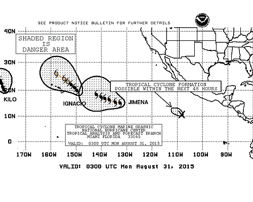
NOAA satellite image, as of 1 p.m.
Hurricane Ignacio was about 380 miles east of Hilo, as of 2 p.m.
The Central Pacific Hurricane Center reports that Ignacio is continuing on its northwest path at about 12 miles per hour.
Maximum sustained winds associated with Hurricane Ignacio also remain consitent with CPHC’s 11 a.m. update at 115 miles per hour.
The storm is expected to continue on its northwest path for the next couple of days.
CPHC’s next full advisory will be released at 5 p.m.
A Tropical Storm Watch remains in effect for the Big Island, as well as Maui County.
***Updated at 11:10 a.m. to include information from the Central Pacific Hurricane Center and the National Hurricane Center’s 11 a.m. advisories. ***
By: Jamilia Epping
As of 11 a.m., Hurricane Ignacio was located 400 miles east of Hilo.
Data from a recent reconnaissance aircraft flight found that Hurricane Ignacio’s maximum sustained winds have decreased to 115 miles per hour, a 15 mph decrease since 8 a.m. Sunday. Ignacio is now being categorized as a Category 3 hurricane.
Hurricane Ignacio is now moving to the northwest at 12 mph.This movement is expect to continue for the next couple of days.
Forecasters say the center of the storm will pass about 200 miles northeast of the Big Island on Tuesday night. It is also expected that as Hurricane Ignacio continues to weaken, the storm will be downgraded to tropical storm status by Tuesday.
A Tropical Storm Watch for the Big Island and Maui County remains in effect.
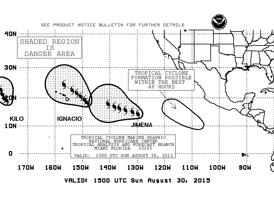
Hurricane Jimena appears to be restrengthening, according to the National Hurricane Center. As of 11 a.m., Jimena was located 1,630 miles east of Hilo.
NHC reports that Hurricane Jimena’s maximum sustained winds have increased to 145 mph and the storm is moving to the west-northwest at 15 mph.
Forecasters say that Hurricane Jimena could become a Category 5 hurricane at some point Sunday.
***Original story posted at 9:37 a.m.***
By: Jamilia Epping
Hurricane Ignacio is taking a north-northwest track, as of the Central Pacific Hurricane Center’s 8 a.m. intermediary advisory.
CPHC says that Igancio was 420 miles east of Hilo with maximum sustained winds of 130 miles per hour, remaining a Category 4 hurricane.
Forecasters have revised their outlook on possible effects from Hurricane Ignacio. Tropical storm force winds are now possible for the Big Island on Monday night, with the center of the storm passing on the same day.
Additionally, possible rainfall amounts are forecast to be between one to three inches, with up to five inches in upper elevations.
A Tropical Storm Watch remains in effect for the Big Island and Maui County.
National Hurricane Center image, as of 5 a.m.
As of 5 a.m. Hurricane Jimena was located 1,725 miles east of Hilo. The Category 4 hurricane has maximum sustained winds of 130 mph
The National Hurricane Center noted that Jimena was moving to the west-northwest at 14 mph.
Hurricane Jimena is expected to slow down by Monday night, however, the storm is forecast to hold on to its major hurricane status.
Sponsored Content


