June 27 Lava Flow Update – 1/10/15
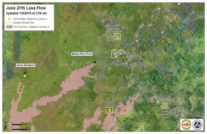
The two north margin breakouts of the June 27 lava flow continue to remain active and have advanced about 30 yards since Friday, moving in a northeast direction, Hawai’i County Civil Defense said Saturday morning following its overflight assessment. These two margin breakouts are located 1-1.5 miles from the stalled flow front.
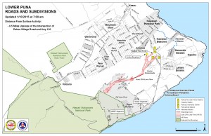
Hawaiian Volcano Observatory says that the lobes have entered a drainage area that will lead to the steepest-decent path that crosses Highway 130 about 0.6 miles south of the Maku’u Farmer’s Market. HVO emphasized that the flow is still 2.1 miles upslope from the area and is moving slowly.
For over a week, the flow front and south margin breakout have remain stalled, showing no signs of advancement. The flow front remains 0.5 miles from the Highway 130 and Pahoa Village Road intersection.
Additional surface activity has continued to occur 300 yards upslope from the stalled flow front and along both the north and south margins of the flow. None of this activity poses a current threat to communities in the area, according to Civil Defense, and they, along with HVO, will continue to monitor flow activity and changes and continue to keep the public informed.
On Friday, a brush fire broke out as a result of the lava flow. Civil Defense says “the fire was contained within the fire break area and extinguished.” The Hawai’i Fire Department is monitoring conditions but no fire activity was observed Saturday morning.
Civil Defense reported light to moderate smoke conditions as a light trade wind was blowing smoke in a southwest direction. As usual, these smoke conditions have the possibility of increasing. Officials advise those who are sensitive or who have respiratory issues take necessary precautions and stay inside.
According to HVO, weak inflationary ground tilt that has been occurring at the summit for the past three days has continued to weaken. “There were a swarm of earthquakes in the upper east rift zone early this morning; 18 quakes occurred within a few minutes of 1 a.m.,” HVO reported in a morning update.
Currently, the summit lava lake shows minor fluctuation, which are changes that are expected as splattering behavior occurs. They also manifest as variations in tremor amplitudes and gas release.
The Railroad Avenue alternate access road has been closed to all traffic since 12 p.m. Wednesday.
Public lava viewing at the Pahoa Transfer station continues. As of Friday, the hours of operation have been modified. The public can visit the viewing site from 10 a.m. to 4:30 p.m. daily, which have been determined as the peak hours of visitation.


