

Island forecast
Hilo, Big Island Weather
Clear daily guidance, radar access and the latest regional weather reporting in one place.
- Change Towns
- Hilo
- Kona
- Ocean View
- Pahala
- Waimea
Multi-day outlook
Forecast timeline
Scroll for the full forecast
Overnight
Monday
Monday Night
Tuesday
Tuesday Night
Wednesday
Wednesday Night
Thursday
Thursday Night
Friday
Friday Night
Saturday
Saturday Night
Sunday
Latest Weather News

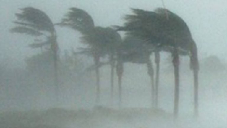
Resilience hubs provide aid to affected residents during kona low storm response
What you need to know about the kona low Sunday on Big Island: County of Hawaiʻi facilities to reopen tomorrow, 14,500 are without power
Water main break affects customers in Konawaena, Nāpōʻopoʻo
Residents urged to file insurance claims after severe weather
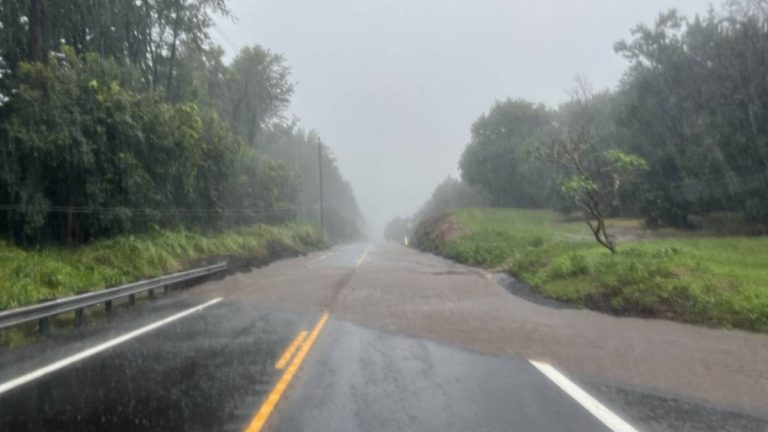
What you need to know about the kona low Saturday on the Big Island: Entire island now under flash flood warning; spots on Ali‘i Drive added to growing list of road closures
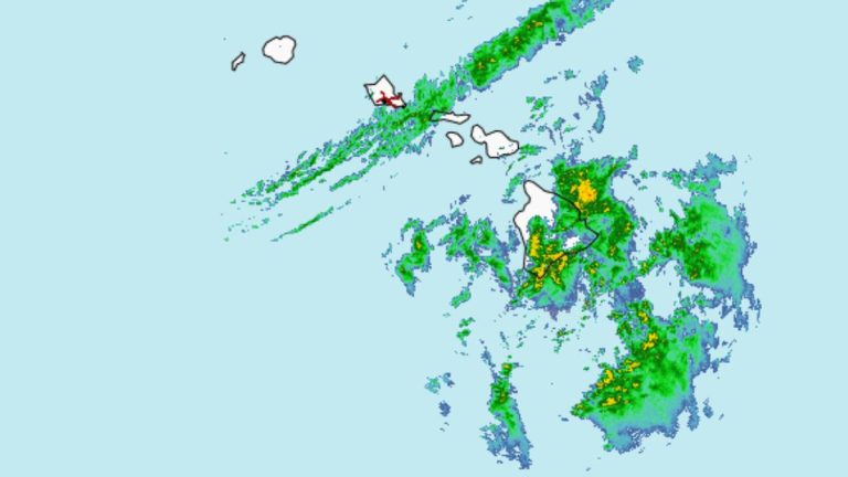
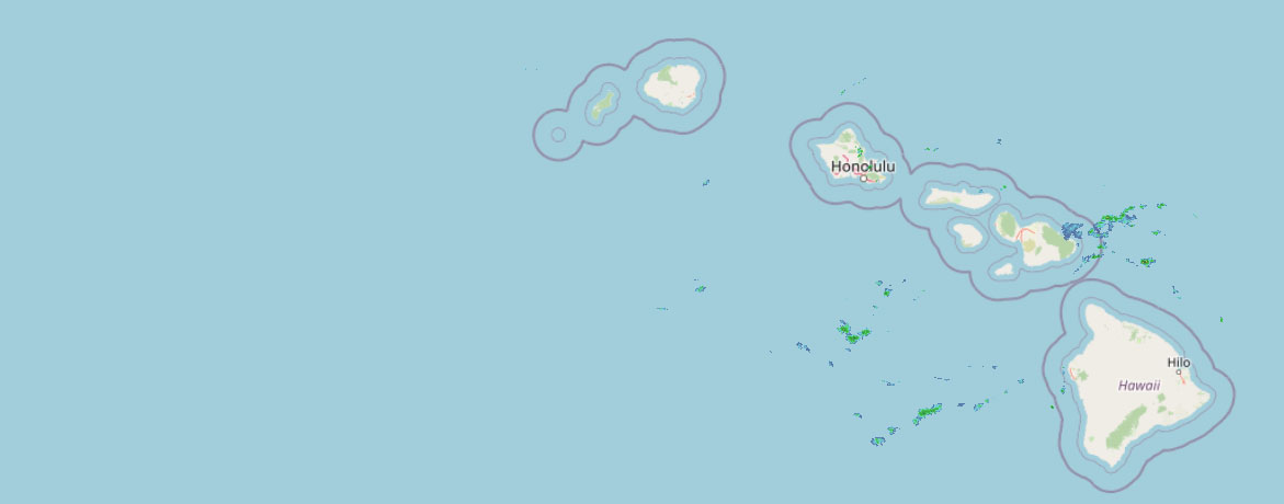 Weather Radar
Regional forecast
Regional Big Island Weather Forecast Hawaii County Weather Forecast for March 16, 2026

Hilo
Tonight: Windy. Showers until early morning, then scattered showers late in the night. Lows 61 to 71 near the shore to 55 to 63 at 4000 feet. South winds up to 30 mph with gusts to 50 mph shifting to the southwest up to 20 mph after midnight. Chance of rain near 100 percent.
Monday: Breezy. Cloudy with scattered showers. Highs 78 to 83 near the shore to 65 to 70 at 4000 feet. South winds up to 25 mph with gusts to 45 mph. Chance of rain 50 percent.
Monday Night: Cloudy with scattered showers. Lows 61 to 71 near the shore to 54 to 61 at 4000 feet. Southeast winds up to 15 mph in the evening becoming light. Chance of rain 50 percent.
Kona
Tonight: Breezy and showers. Lows 69 to 74 near the shore to 51 to 56 near 5000 feet. South winds up to 20 mph. Chance of rain near 100 percent.
Monday: Breezy and showers. Highs 80 to 86 near the shore to around 66 near 5000 feet. South winds up to 20 mph. Chance of rain near 100 percent.
Monday Night: Showers. Lows 68 to 73 near the shore to 49 to 54 near 5000 feet. South winds up to 15 mph. Chance of rain near 100 percent.
Waimea
Tonight: Windy and showers. Lows 62 to 71 near the shore to 57 to 64 near 3000 feet. Southwest winds up to 30 mph with gusts to 60 mph decreasing to up to 20 mph with gusts to 45 mph after midnight. Chance of rain near 100 percent.
Monday: Breezy and showers. Highs around 79 near the shore to 69 to 75 near 3000 feet. Southeast winds up to 20 mph shifting to the northwest in the afternoon. Gusts up to 40 mph. Chance of rain near 100 percent.
Monday Night: Cloudy and breezy. Showers early in the evening, then numerous showers in the late evening and overnight. Lows 63 to 71 near the shore to 55 to 62 near 3000 feet. Southwest winds up to 20 mph. Chance of rain 90 percent.
Kohala
Tonight: Windy and showers. Lows 62 to 71 near the shore to 57 to 64 near 3000 feet. Southwest winds up to 30 mph with gusts to 60 mph decreasing to up to 20 mph with gusts to 45 mph after midnight. Chance of rain near 100 percent.
Monday: Breezy and showers. Highs around 79 near the shore to 69 to 75 near 3000 feet. Southeast winds up to 20 mph shifting to the northwest in the afternoon. Gusts up to 40 mph. Chance of rain near 100 percent.
Monday Night: Cloudy and breezy. Showers early in the evening, then numerous showers in the late evening and overnight. Lows 63 to 71 near the shore to 55 to 62 near 3000 feet. Southwest winds up to 20 mph. Chance of rain 90 percent.
South Big Island
Tonight: Showers. Lows around 75 near the shore to around 58 near 5000 feet. West winds up to 15 mph. Chance of rain near 100 percent.
Monday: Cloudy. Showers until late afternoon, then numerous showers late in the afternoon. Highs around 82 near the shore to around 65 near 5000 feet. West winds up to 15 mph. Chance of rain 90 percent.
Monday Night: Cloudy with numerous showers. Lows around 74 near the shore to around 55 near 5000 feet. West winds up to 15 mph. Chance of rain 70 percent.
Puna
Tonight: Windy. Showers until early morning, then scattered showers late in the night. Lows 61 to 71 near the shore to 55 to 63 at 4000 feet. South winds up to 30 mph with gusts to 50 mph shifting to the southwest up to 20 mph after midnight. Chance of rain near 100 percent.
Monday: Breezy. Cloudy with scattered showers. Highs 78 to 83 near the shore to 65 to 70 at 4000 feet. South winds up to 25 mph with gusts to 45 mph. Chance of rain 50 percent.
Monday Night: Cloudy with scattered showers. Lows 61 to 71 near the shore to 54 to 61 at 4000 feet. Southeast winds up to 15 mph in the evening becoming light. Chance of rain 50 percent.
Waikoloa
Tonight: Windy and showers. Lows around 73 near the shore to 54 to 59 above 4000 feet. South winds up to 30 mph with gusts to 50 mph. Chance of rain near 100 percent.
Monday: Breezy and showers. Highs around 83 near the shore to 64 to 71 above 4000 feet. Southwest winds up to 20 mph. Chance of rain near 100 percent.
Monday Night: Showers. Lows around 73 near the shore to 52 to 57 above 4000 feet. South winds up to 15 mph. Gusts up to 35 mph in the evening. Chance of rain near 100 percent.
Detailed Forecast
Synopsis
Periods of moderate to heavy rain continue over Leeward Big Island and Maui while conditions improve elsewhere. There is a threat for heavy rain during the latter half of this week as low pressure develops west of the islands.
Short term update
Issued at 820 PM HST Sun Mar 15 2026
The kona low has meandered well north of the islands; however, showers continue to sock in Maui County and the Big Island, where Flash Flood Watches remain in place. It's anticipated that showers will ease throughout the overnight period, allowing the aforementioned Watch to be canceled by the morning forecast package. Meanwhile, latest observations continue to depict the summits of Big Island gusting well above High Wind Warning threshold. Model guidance suggests these winds will fall below threshold around the time of the next package, warranting the downgrade to a Wind Advisory; however, this will be reassessed later tonight. Largely, the forecast remains on track, so apart from just updating the winds and temperatures with the latest trends, no amendments were necessary at this time.
Prev discussion
Moisture embedded within deep layer SW flow extends well upstream of the Big Island and will continue to deliver waves of rainfall through at least Monday night and potentially Tuesday. However, the lack of large scale forcing during this time will likely result in a trend toward lower intensity rainfall compared to what was observed yesterday or even today. At the same time, the weakening background wind field may allow the overnight mountain breeze to more effectively focus stronger convection offshore at night. Rather nondescript surface pressure and wind fields takes shape during Tuesday which should finally bring an end to the steady stream of rainfall. At this time, the Flood Watch will remain in effect for the Big Island and Maui, though confidence in the moisture band lifting sufficiently far north to impact Maui again is low at this time. The Wind Advisory will end with issuance of the afternoon forecast package, and the High Wind Warning for Haleakala and the Big Island summits will be extended through tonight.
Attention then turns to mid to late week when the remnant frontal band reactivates in response to renewed mid/upper forcing followed by potential development of low pressure west of the islands during the second half of the week. The first upper wave arrives late Wednesday. Mid- level flow will still be southwesterly at this time, though it is uncertain whether boundary layer flow will will be in a state of weak trades of out of the south. In any case, an uptick in showers is anticipated over the islands by Wednesday night. Surface pressure falls will already be taking place upstream of the islands during this time as a trailing upper wave approaches the islands from the northwest. Model consensus previously broke down at this point with the GFS indicating a flatter and more progressive surface low while the EC indicated a deeper and slower moving low. The most recent run of the GFS has made a strong move toward the EC increasing confidence that organized low pressure will develop over or near the islands by late this week. Moderate to heavy rain then potentially develops over the islands as early as Friday and would continue into the weekend.
Aviation
Issued at 820 PM HST Sun Mar 15 2026
The system that has plagued the area continues to move northeast. Low cigs and SHRA continue across the area and will slowly decrease from west to east tonight into tomorrow. Some MVFR conds are possible. The lone exception is Lanai which is LIFR with fog thats expected to last into the morning. Winds have weakened over the state and will continue that trend into tomorrow. There still could still be some gusty winds especially over Maui and the Big Island.
AIRMET Sierra is in effect for mtn obsc from Molokai to the Big Island. Oahu may be added especially over windward locations overnight. Conds in general will imp west to east and this AIRMET will be adjusted as necessary.
AIRMET Tango remains in effect for mod mid-upper level turb between 130 and FL330. It is is also in effect for turb downwind N thru E of terrain statewide. As winds diminish and this system moves further away from the islands this will be adjusted in the overnight hours.
Light icing is possible between 130 and FL260 as mid-high clouds continue moving through the islands.
Marine
The kona storm that has impacted the region over the past few days will weaken as it moves northeast and away from the area, with conditions improving over the coastal waters. Latest hi-res guidance shows that locally strong winds may linger over portions of the central and eastern waters tonight. Additionally, buoy observations show that seas remain elevated, with Barber's Point and Hanalei still reporting 10ft and 12ft significant wave heights this afternoon, respectively. Therefore, the Small Craft Advisory (SCA) that was previously in effect has been extended in time through tonight to capture the seas for the western waters and locally breezy winds in the central and eastern waters (with the exception of the Southeast Big Island zone where the SCA has been cancelled). By early Monday, both winds and seas are expected to fall below advisory criteria. Winds will then remain light and variable through mid-week. Ridging is forecast to strengthen north of the islands late in the week, which should bring a return of moderate to fresh trade winds.
Large, rough surf along south-facing shores that has been observed over the past few days will trend lower tonight and Monday as wind speeds subside. A new long-period south swell will arrive late Monday night and Tuesday, giving an extended boost to south shore surf through late this week.
A moderate sized, short-period west-northwest swell will continue to affect north and west facing shores through Monday, but surf will remain below advisory levels. The one exception is for west facing shores of the Big Island, where a High Surf Advisory remains in effect through 6 AM HST. This short-period swell will lower Monday night and Tuesday, while a new medium-period north- northwest swell fills in. This north-northwest swell could bring surf up to advisory levels Tuesday night and Wednesday, with the swell then shifting more northerly and lowering below advisory levels Thursday into next weekend.
Surf along east facing shores will remain well below normal levels through the middle of the week, before trending upward Thursday into next weekend as trade winds return over and upstream of the islands.
HFO Watches/Warnings/Advisories
Flood Watch until 6 AM HST Monday for Big Island East, Big Island Interior, Big Island North, Big Island South, Big Island Southeast, Haleakala Summit, Kahoolawe, Kipahulu, Kohala, Kona, Lanai Leeward, Lanai Mauka, Lanai South, Lanai Windward, Maui Central Valley North, Maui Central Valley South, Maui Leeward West, Maui Windward West, Molokai Leeward South, Molokai North, Molokai Southeast, Molokai West, Molokai Windward, South Haleakala, South Maui/Upcountry, Windward Haleakala.
High Wind Warning until 6 AM HST Monday for Big Island Summits, Haleakala Summit.
High Surf Advisory until 6 AM HST Monday for Kohala, Kona.
Small Craft Advisory until 6 AM HST Monday for Alenuihaha Channel, Big Island Leeward Waters, Big Island Windward Waters, Kaiwi Channel, Kauai Channel, Kauai Leeward Waters, Kauai Northwest Waters, Kauai Windward Waters, Maalaea Bay, Maui County Leeward Waters, Maui County Windward Waters, Oahu Leeward Waters, Oahu Windward Waters, Pailolo Channel.
Big Island Now Weather is brought to you by Blue Hawaiian Helicopters.
Check out their Big Island Helicopter Tours today!
Data Courtesy of NOAA.gov