*** Updated at 1:20 p.m. to include additional information from Hawai’i County Civil Defense. ***
Hawai’i County Civil Defense’s overflight assessment of the June 27 lava flow was delayed on Wednesday morning due to a flight schedule conflict.
Upon conducting its assessment, Civil Defense noted minimal activity in the downslope areas of the flow. Breakouts, however, continued to prevail upslope, beginning about 8 miles upslope and extending to the summit area of Pu’u O’o.
Light smoke conditions were reported as light variable winds were blowing the smoke in a south direction. Burning was limited to vegetation in the vicinity of the upslope breakouts. As usual, these conditions have the potential to change.
ARTICLE CONTINUES BELOW AD
ARTICLE CONTINUES BELOW AD
***Original Story posted at 9:41 a.m. ***
A Hawaiian Volcano Observatory overflight on Tuesday showed that the June 27 lava flow continues to be active in the upslope region with three specific breakouts being observed.
Northeast of Puʻu ʻŌʻō, the areas that remain active are the northern plank of Puʻu ʻŌʻō, also being referred to as the Feb. 21 breakout, an area near Pu’u Kahauale’a, and a breakout about 3-4 miles northeast of Puʻu ʻŌʻō.
ARTICLE CONTINUES BELOW AD
Webcam images, along with HVO’s overflight assessment, showed that the furthest northeast breakout has continued to burn forested area.
At Puʻu ʻŌʻō, the tiltmeter along the north flank continues to show no significant tilt. Tiltmeters at Kilauea’s summit, however, have continued to record inflationary tilt, which is consistent with the phase of the current DI event.
HVO officials also say that the summit lava lake level has raised. The observatory reported Wednesday morning that the lake raised to about 115-130 feet below the rim of the Overlook crater.
ARTICLE CONTINUES BELOW AD
Conditions will continue to be monitored by HVO and Hawai’i County Civil Defense. Any change in activity will be announced to the public.
+
SWIPE LEFT OR RIGHT
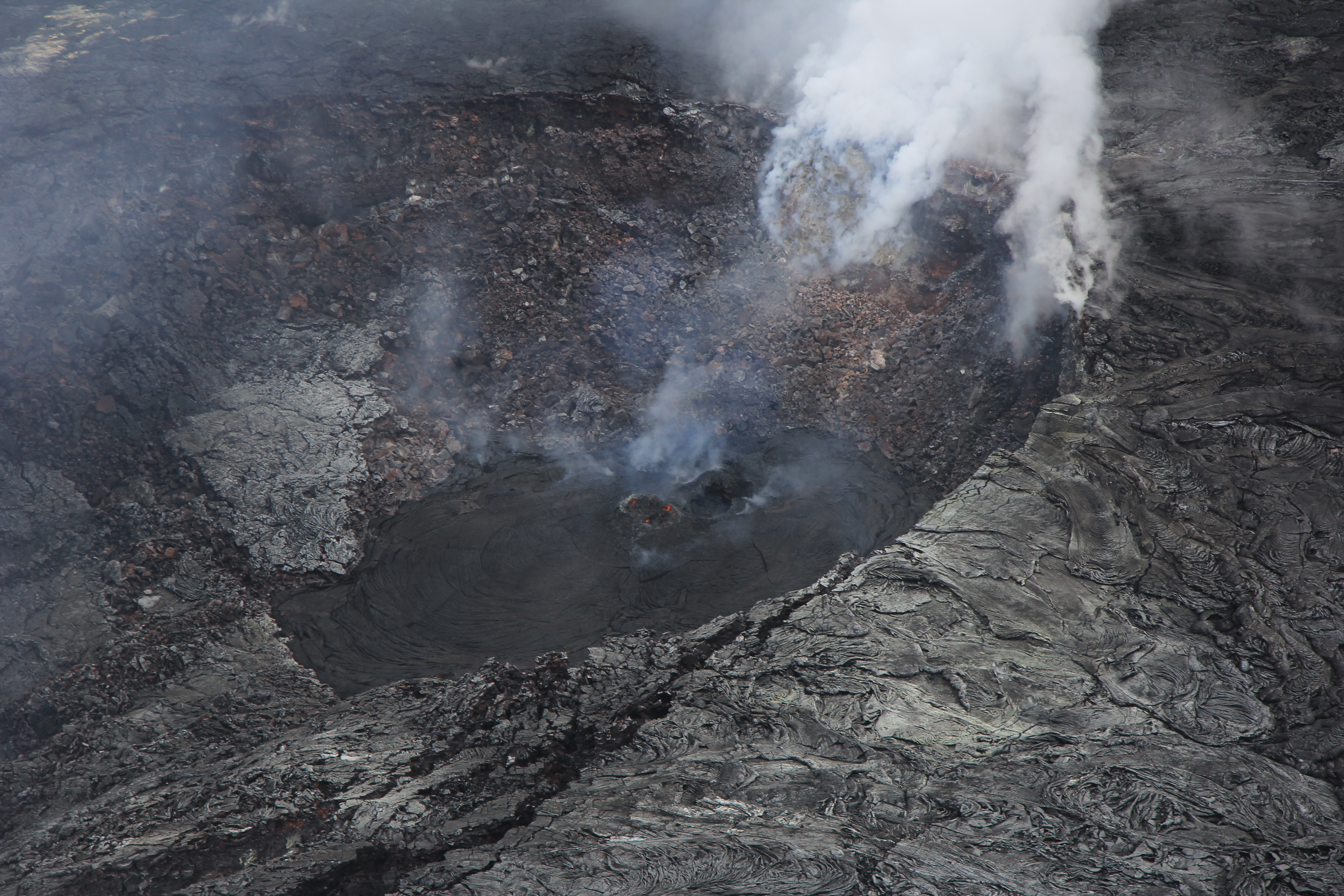
There are several incandescent and outgassing hornitos on the floor of Puʻu ʻŌʻō’s crater, including the one shown in this photo, taken on March 24, which is at the northeast edge of the crater. Recent flows from the hornito appear black. USGS HVO photo.
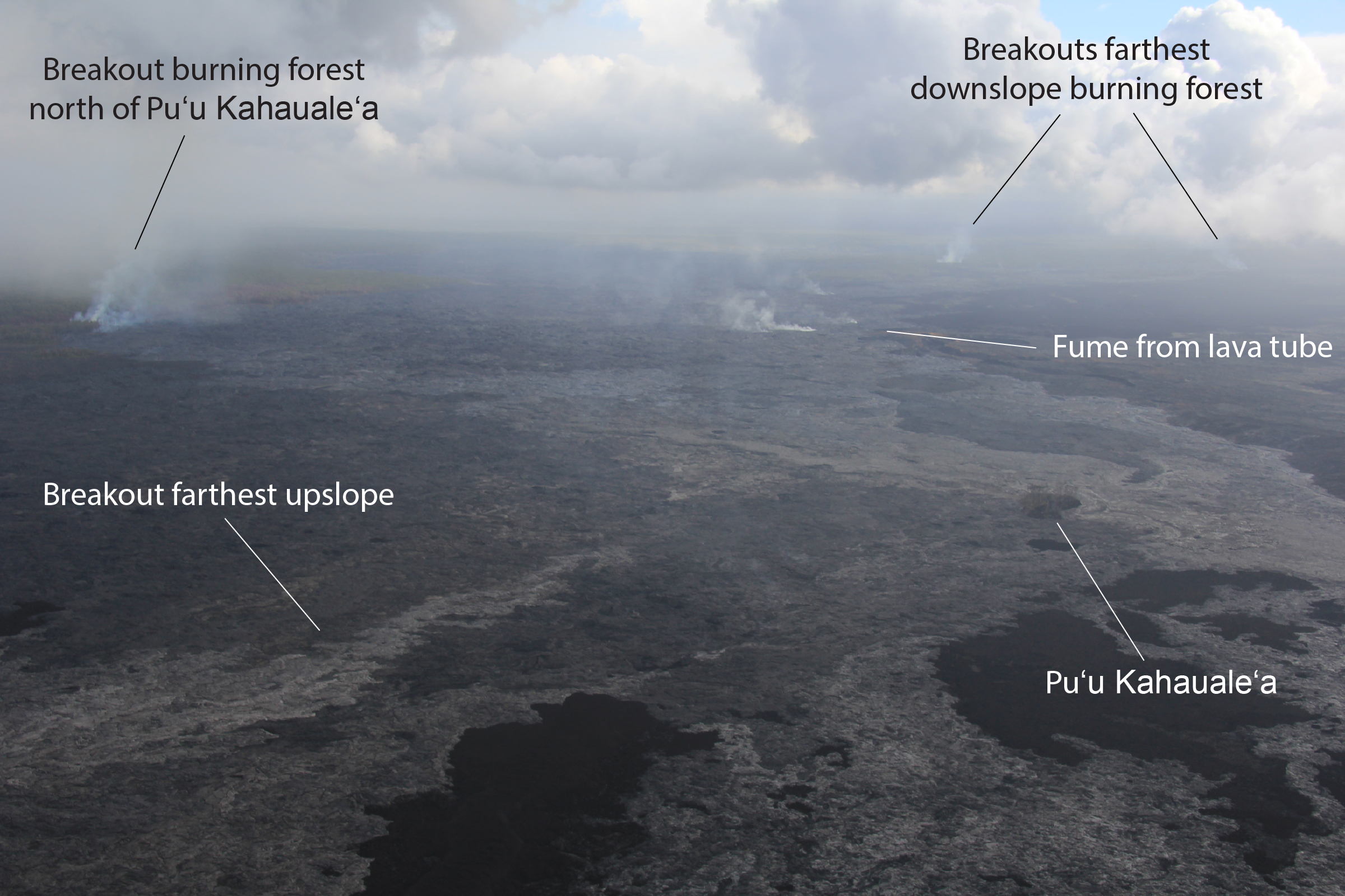
This image, taken on March 24, shows breakouts that were active in three general areas near Puʻu ʻŌʻō: at the northern base of Puʻu ʻŌʻō, north Kahaualeʻa, and about 6 km (4 mi) northeast of Puʻu ʻŌʻō. The distal breakout and the breakout north of Kahaualeʻa were both burning forest. There is no eruptive activity downslope from the distal breakout (nothing active near Pāhoa). USGS HVO photo.
This comments section is a public community forum for the purpose of free expression. Although Big Island Now encourages respectful communication only, some content may be considered offensive. Please view at your own discretion. View Comments