The latest update on Tropical Storm Ana was just released by the Central Pacific Hurricane Center. There was a slight decrease in forward motion, but not much of a change in intensity or forecast track. Ana is getting closer and expected to intensify over the next 36 hours to hurricane status.
Summary of Alerts
HURRICANE WARNING – All Hawaiian Offshore Waters, starting Friday afternoon
TROPICAL STORM WARNING – All Hawaiian Offshore Waters, starting tonight
TROPICAL STORM WATCH – Currently in effect for Hawai’i County
FLASH FLOOD WATCH – Hawaiʻi County, starting Friday at noon until Sunday at 6 p.m.
ARTICLE CONTINUES BELOW AD
ARTICLE CONTINUES BELOW AD
Current Situation (11 a.m. Update)
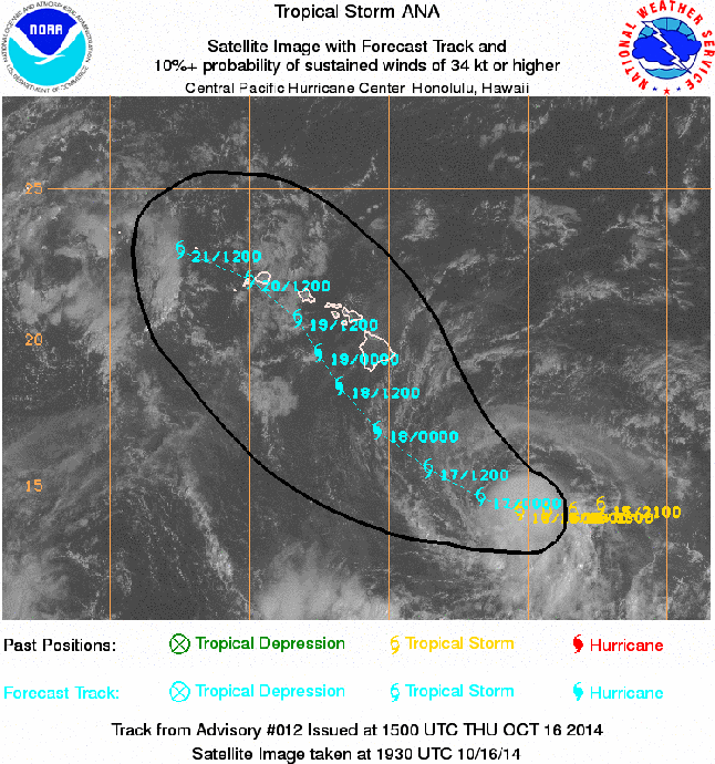
Ana remains a tropical storm with 60 mph maximum sustained winds and gusts up to 70 mph. Tropical storm force winds extend 60 miles from the center. Ana is moving west at 8 mph.
Tropical Storm Ana was last located near 14.3 N and 150.9 W, about 460 miles southeast of Hilo; 505 miles southeast of Kailua-Kona, 450 miles southeast of South Point, 580 miles southeast of Kahului, Maui; 625 miles southeast of Kaunakakai, Molokaʻi; 595 miles southeast of Lānaʻi City; and 665 miles southeast of Honolulu, Oʻahu.
Ana was looking tattered last night, and today’s satellite imagery is showing a storm that’s pretty ragged, however, deep bursts of convection continue to occur and the storm is holding onto its 60 mph max sustained winds. A ridge building to the north of the state is expected to help steer the storm. The timing of the northwest turn is integral to the forecast. We’ll keep watching this closely.
The Central Pacific Hurricane Center is indicating that the intensity forecast is now becoming a little more certain with all but one model indicating gradual strengthening. Sea surface temperatures are more than sufficient to fuel ANA and vertical wind shear is expected to decrease so the environment is favorable for this.
The current track has not changed much with Ana passing 85 miles southwest of the Island of Hawaiʻi Friday night and Saturday, passing Maui County Saturday into Sunday and nearing Oʻahu and Kauaʻi over the weekend and into Monday.
The probability of tropical storm conditions over Big Island leeward and southeast coastal waters is 65 percent; 29 percent in Hilo; 49 percent in Kailua-Kona and 59 percent near South Point.
Remember, these systems are notoriously difficult to predict and the center of the storm has a 66 percent chance of landing anywhere within the cone of uncertainty. The margin of error going out 48 hours is still a whopping 80 miles. Even small shifts in the track can mean major differences in where the worst conditions will occur. Damaging effects can extend far from the center so it’s important that residents prepare just in case.
Potential Impacts (if the track holds)
ARTICLE CONTINUES BELOW AD
Heavy rain may reach the Big Island late Friday, potentially causing dangerous flash flooding with excessive runoff causing possible mud slides and rock slides.
Large dangerous surf conditions are expected to begin impacting the eastern end of the Hawaiian islands late Thursday.
Big Island –
The local forecast calls for 10 to 15 inches of rain with locally up to 20 inches along southeast facing slopes beginning Friday afternoon.
Winds of 25 to 40 mph, gusting to 60 mph, are possible Friday and Saturday
Seas of 15 to 25 feet are expected. Surf heights of 20 to 30 feet are possible late Friday along the Puna & Kaʻū coastlines during the closest approac, peaking Friday night
This comments section is a public community forum for the purpose of free expression. Although Big Island Now encourages respectful communication only, some content may be considered offensive. Please view at your own discretion. View Comments