The National Weather Service today said a wind advisory for the Big Island, Lanai and Kahoolawe has been extended to 6 p.m. tonight.
A surface low-pressure system 1,350 miles northeast of the state is driving the gusty trade winds, which forecasters said are expected to ease over the next several days.
Winds from the northeast, with some easterlies, are expected to be in the 25 to 35 mph range today with gusts near 50 mph.
ARTICLE CONTINUES BELOW AD
ARTICLE CONTINUES BELOW AD
Areas to be affected include Honokaa, Hilo, Volcano and Pahala, although the winds are expected to be strongest at South Point and in the Waimea to Kawaihae corridor in leeward Kohala where their effects are magnified by downward slopes.
Posted 12:34 p.m. Monday, April 14:
Parts of the Big Island are included in a wind advisory for Hawaii in effect until 6 p.m., the National Weather Service said.
ARTICLE CONTINUES BELOW AD
Winds out of the northeast are expected to be in the 20-35 mph range with localized gusts of more than 45 mph.
The gusty trades are being generated by a high-pressure system northeast of the state.
Areas most affected are those exposed to downslope wind gusts, such as the leeward Kohala area, the Waimea to Kawaihae corridor, the western portion of the saddle and in the area around South Point.
ARTICLE CONTINUES BELOW AD
The winds could reach 65 mph on the summits of Mauna Loa and Mauna Kea.
The winds are contributing to a high surf and small craft advisories in place until 6 p.m. Tuesday for northeast-facing shores and surrounding waters of all islands.
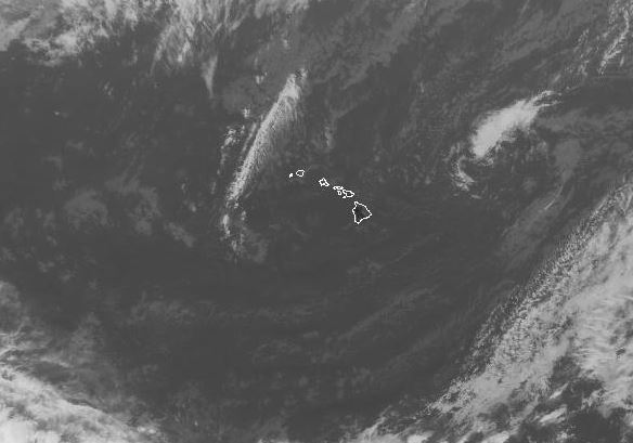
A high-pressure system northeast of the island (upper right corner) is driving gusty northeasterlies and prompting a wind advisory for Hawaii. NOAA/NWS image.
Not much moisture is coming in with the northeasterlies, although as they ease into Wednesday some moisture from a disintegrating low-pressure system east of Hawaii is expected to come in on the trade flows.
The difference in pressure between the high and low is expected to cause the trades to pick up again by the end of the week.
This comments section is a public community forum for the purpose of free expression. Although Big Island Now encourages respectful communication only, some content may be considered offensive. Please view at your own discretion. View Comments