

UPDATE: High surf advisory canceled for Big Island east-facing shorelines
Update at 4:02 a.m. Feb. 21, 2026: National Weather Service forecasters in Honolulu canceled a high surf advisory that was previously in place until 6 a.m. today for east-facing shores of the Big Island.
Data indicate surf along eastern shorelines has fallen below advisory levels.
Update at 3 p.m. Feb. 20, 2026: A high surf advisory has been extended for Big Island until 6 a.m. on Saturday.
Surf along exposed east-facing shores will remain rough, with heights hovering around the advisory threshold through today. A downward trend will follow over the weekend as the winds diminish.
Surf is expected to reach 7 to 10 feet. Impacts are moderate as strong breaking waves and currents make swimming dangerous.
Update at 3:53 a.m. Feb. 20, 2026: Surf along exposed east-facing shores of the Big Island will remain rough through today, with heights continuing to hover near advisory levels.
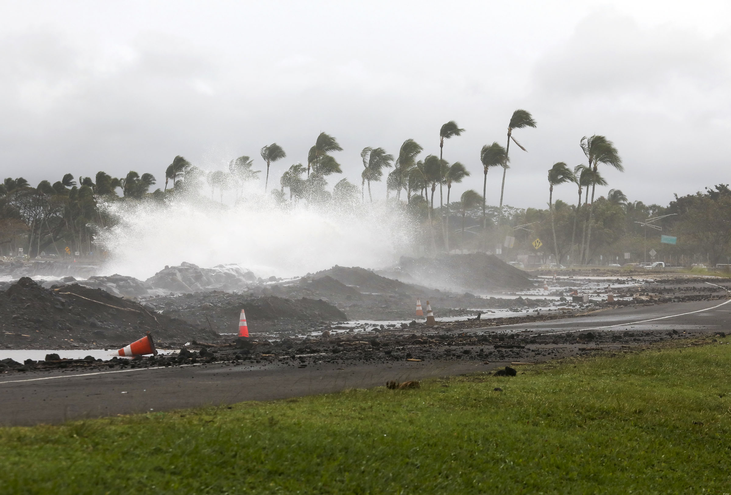
As a result, National Weather Service forecasters in Honolulu again extended the high surf advisory in effect for those eastern shorelines of the island. It remains in place now until 6 p.m. today.
A downward trend is expected through the weekend, however, as winds diminish.
Surf of 8 to 12 feet is forecast for this morning, with heights falling to 7 to 10 feet this afternoon.
Update at 6:26 a.m. Feb. 18, 2026: National Weather Service forecasters in Honolulu report that strong trade winds continue to cause rough ocean conditions and high surf.
Advisory level surf is now forecast to be in place through Thursday (Feb. 19) along east-facing shores of the Big Island. Therefore, the high surf advisory that previously was in effect until this morning is extended until 6 p.m. Thursday.
Surf of 8 to 12 feet will continue to cause strong breaking waves and strong currents that will make swimming and other ocean activities along those eastern shorelines dangerous.
Update 4:24 p.m. Feb. 16, 2026: The National Weather Service has extended the high surf advisory for north- and east-facing shores of Hawaiʻi Island through Wednesday morning, Hawaiʻi County Civil Defense officials said Monday afternoon.
The advisory covers coastal areas in North Kohala, Hāmākua, North Hilo, South Hilo, Puna and Kaʻū.
Forecasters said surf along those shorelines will remain higher than normal, with strong breaking waves and powerful currents expected to create dangerous ocean conditions. Officials warned that the elevated surf will make swimming and other ocean activities hazardous along eastern shores.
Beachgoers, swimmers and surfers are urged to follow guidance from ocean safety personnel and use caution if entering the water.
A wind advisory also remains in effect through Tuesday evening for most of Hawaiʻi Island.
4:19 a.m. Feb. 16, 2026: Strong trade winds will maintain relatively short-period high surf along east-facing shores of the Big Island lasting into Wednesday.
As a result, the National Weather Service forecast office in Honolulu has extended the high surf advisory until 6 p.m. Tuesday (Feb. 17) for the eastern shores of the North Kohala, Hāmākua, North and South Hilo, Puna and Kaʻū districts.
Large breaking waves of 7 to 12 feet are still expected.
Story originally posted at 5:38 p.m. Saturday, Feb. 14, 2026: Already strong trade winds will strengthen another notch Sunday (Feb. 15) and produce high surf along east-facing shores during the next several days throughout the state.
As a result, National Weather Service forecasters in Honolulu issued a high surf advisory in effect until 6 a.m. Tuesday (Feb. 17) for eastern shorelines of North Kohala, Hāmākua, North and South Hilo, Puna and Kaʻū districts on the Big Island.
A high surf advisory means surf will be higher than normal. Strong breaking waves and strong currents also will make swimming and other ocean activities dangerous.
Large breaking waves of 7 to 10 feet are forecast, rising to surf of 8 to 12 feet by late Sunday into Sunday night for eastern shores.
“Beach-goers, swimmers and surfers should heed all advice given by ocean safety officials and exercise caution when entering the water,” said Hawai‘i County Civil Defense in a message Saturday afternoon.
National Weather Service forecasters reminded the public: when in doubt, don’t go out.
Winds are expected to stay strong through the middle of next week, so the advisory could be extended.
Visit the Hawai‘i County Hazard Impact Map for additional information.
Head to the National Weather Service Honolulu forecast office website for the most up-to-date weather information, including advisories, watches and warning.
Sponsored Content


