

8:45 PM Update: Lava Evaporates Green Lake
This news story will be updated throughout the day as new information becomes available and new articles will be added to the website’s “News” section. Previous information about ongoing events can be found in Big Island Now’s “Volcano Blog” section.
June 2, 2018, at 8:45 p.m.:
Vigorous eruption of lava continues from the lower East Rift Zone (LERZ) fissure system in the area of Leilani Estates and Lanipuna Gardens.
Fountaining at Fissure 8 continued unabated during the day, feeding a channelized lava flow to the northeast along Highway 132 that has crossed Highway 137 at the intersection of the two highways at 9:30 a.m. Saturday, June 2, 2018. The flow continued advancing into Kapoho Crater and Kapoho Beach Lots. At 10 a.m. lava entered Green Lake within Kapoho Crater producing a large steam plume. By 1:30 p.m. the steam plume had ceased and by 3 p.m., a Hawai‘i County Fire Department overflight reported that lava had filled the lake and apparently evaporated all the water.
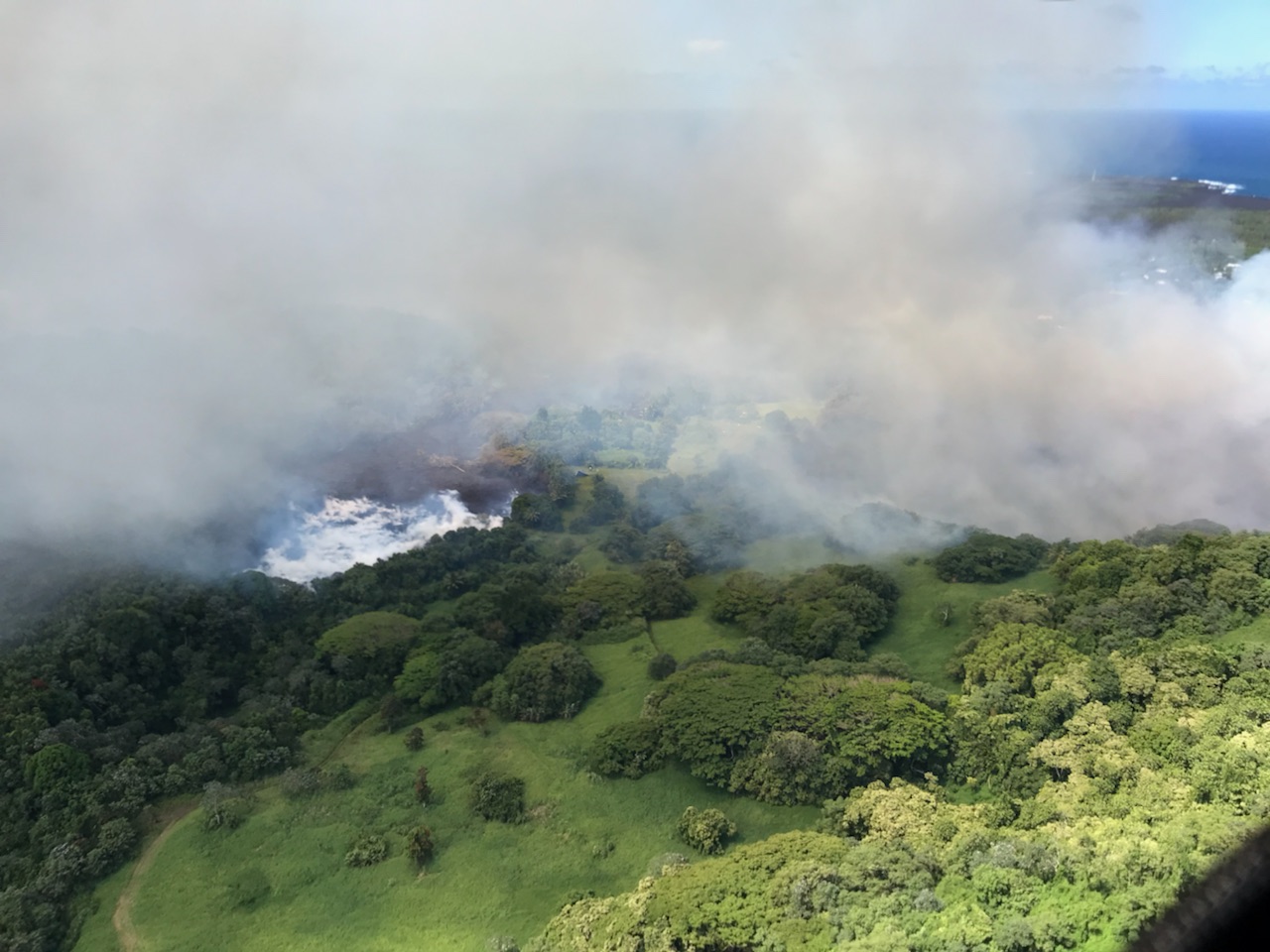
USGS Photo. Click to enlarge
Other branches of the Fissure 8 lava flow were inactive.
The only other lava flow noted by the morning overflight was at Fissure 16, which was weakly active.
Pele’s hair and other lightweight volcanic glass from high fountaining of Fissure 8 are falling downwind of the fissure and accumulating on the ground within Leilani Estates. Winds may waft lighter particles to greater distances. Residents are urged to minimize exposure to these volcanic particles, which can cause skin and eye irritation similar to volcanic ash.
June 2, 2018, at 6 p.m.:
Hawai‘i County Civil Defense Administrator Talmadge Magno confirmed (3:23 mark of video) there was a suicide at the Pāhoa Evacuation Shelter on Thursday, May 31, 2018, and the Hawai‘i Police Department is investigating the incident.
https://www.facebook.com/BigIslandNow/videos/1673773232700219/
Hawaiian Volcano Observatory reports that vigorous lava eruptions continue throughout the lower East Rift Zone in Leilani Estates and Lanipuna Gardens. Fissure 8 is feeding a large channelized flow traveling along Highway 132, the Pāhoa-Kapoho Road.
Lava has crossed Government Beach Road and Highway 137, and inundated the Four Corners intersection. The flow is moving downslope toward the ocean into Kapoho Beach Lots.
Due to lava crossing Highway 137, the following policies are in effect:
- There is no access to Kapoho, Vacationland, Highway 132 and Highway 137.
On roadways:
- Government Beach Road, between Kahakai Boulevard and Cinder Road, is open to Waa Waa and Papaya Farms Road residents only with official credentials. There is no curfew.
Volcanic gas emissions remain high at the Kīlauea summit and in the fissure system. Residents in communities downwind should take action to limit exposure to gas and ash. On the coast, be aware of laze gas from the ocean entry.
Stay alert to warnings from Civil Defense officials and be prepared to evacuate with little notice.
Shelters at Pāhoa Community Center and Kea‘au Armory are open and pet friendly.
June 2, 2018, at 1 p.m.:
Hawaiian Volcano Observatory reports that vigorous lava eruptions continue throughout lower East Rift Zone in Leilani Estates and Lanipuna Gardens. Fissure 8 is feeding a large channelized flow traveling along Highway 132, the Pāhoa-Kapoho Road, with two flow fronts.

This image is from a temporary research camera positioned near Kapoho looking southwest. From left to right, one can see the eruptive fissures, with Fissure 15 on the far left, and Fissure 10 near the center. Last Updated June 2, 2018 at 1:05 p.m.
The northern flow front is above Four Corners, near the intersection. The southern flow front crossed Highway 137, Kalapana-Kapoho Road, 300 feet south of the Four Corners intersection. Part of the flow hit Green Lake and is creating a steam plume in the area. The flow is moving downslope toward the ocean.
Due to lava crossing Highway 137, the following policies are in effect:
- There is no access to Kapoho, Vacationland, Highway 132, and Highway 137.
On roadways:
- Government Beach Road, between Kahakai Boulevard and Cinder Road, is open to Waa Waa and Papaya Farms Road residents only with official credentials. There is no curfew.
Stay alert to warnings from Civil Defense officials and be prepared to evacuate with little notice.
Shelters at Pāhoa Community Center and Kea‘au Armory are open and pet friendly.
June 2, 2018, at Noon:
Hawaiian Volcano Observatory reports that vigorous lava eruptions continue throughout lower East Rift Zone in Leilani Estates and Lanipuna Gardens. Fissure 8 is feeding a large flow traveling along Highway 132, the Pahoa-Kapoho Road. The flow front has crossed Highway 137, south of Four Corners.
Due to lava crossing Highway 137, Kapoho-Pohoiki Road, the following policies are in effect:
- There is no access to Kapoho, Vacationland, Highway 132 and Highway 137.
On roadways:
- Government Beach Road, between Kahakai Boulevard and Cinder Road, is open to Wa‘a Wa‘a and Papaya Farms Road residents only with official credentials. There is no curfew.
Stay alert to warnings from Civil Defense officials and be prepared to evacuate with little notice.
Shelters at Pāhoa Community Center and Kea‘au Armory are open and pet friendly.
USGS scientists on HVO’s overflight on Saturday, June 2 captured this image of the fissure 8 flow front as it advanced west along Highway 132.

Click to enlarge
Around the time of this photo, 7:15 a.m., the flow front was approximately 100 yards west of the Hwy 132/137 intersection and advancing along a broad front over 300 yards in width extending both north and south of Highway 132.
U.S. Geological Survey
Vigorous eruption of lava continues from the lower East Rift Zone (LERZ) fissure system in the area of Leilani Estates and Lanipuna Gardens.
Fountaining at Fissure 8 continued unabated overnight, feeding a channelized lava flow to the northeast along Highway 132 and down into the Four Corners region (at the intersection of Highways 132 and 137). As of 6:40 am, the flow front was approximately 100 yards west of the intersection and advancing along a broad front over 300 yards in width extending both north and south of Highway 132. Small overflows from the Fissure 8 channel are common, some of which are occurring near the intersection of Highway 132 and Pohoiki road. Other branches of the Fissure 8 lava flow were inactive.
The only other lava flow noted by the morning overflight was at Fissure 16, which was weakly active.
Pele’s hair and other lightweight volcanic glass from high fountaining of Fissure 8 are falling downwind of the fissure and accumulating on the ground within Leilani Estates. Winds may waft lighter particles to greater distances. Residents are urged to minimize exposure to these volcanic particles, which can cause skin and eye irritation similar to volcanic ash.
Kīlauea Volcano Summit
Earthquake activity at the summit overnight was calm. Ash emissions are low as revealed by webcam views this morning. Small explosive events, like that of Friday afternoon, could produce minor amounts of ash fall downwind at any time. Volcanic gas emissions at the summit remain high.
June 2, 2018, at 8 a.m.:
The eruptions and lava flows continue in the East Rift Zone of the Big Island.
Map as of 6 p.m., June 1, 2018.

Click to enlarge
Given the dynamic nature of Kīlauea’s lower East Rift Zone eruption, with changing vent locations, fissures starting and stopping, and varying rates of lava effusion, map details shown here are accurate as of the date/time noted. Shaded purple areas indicate lava flows erupted in 1840, 1955, 1960 and 2014-2015.
Hawaiian Volcano Observatory reports that vigorous lava eruptions continue in the lower East Rift Zone fissure system. Fissure 8 is very active and producing a large flow. The flow front has reached Highway 132 and is currently about 150 yards from the Four Corners area. At the present rate, it is possible the flow may cross Government Beach Road near Four Corners within hours.

Panorama of Lower East Rift Zone Camera from Lower East Rift Zone [PGcam]
Last Updated June 2, 2018, at 7:59 a.m.
- Government Beach Road, between Kuna Street and Four Corners, is open to residents only with official credentials. There is no curfew.
- All residents in Vacationland, Kapoho Beach Lots and in areas near Highway 137 are encouraged to evacuate, or risk the possibility of being isolated.
Shelters at the Kea‘au Community Center and the Sure Foundation Church were relocated to the Kea‘au Armory, behind Herbert Shipman Park off of Highway 11. The shelters at Pāhoa Community Center and Kea‘au Armory are open and pet friendly.
The Pāhoa Post Office is open during normal business hours with temporary Sunday hours from 10 a.m. to 2 p.m. for mail and package distribution only.

Viewed from the intersection of Nohea and Leilani Streets at 10:15 a.m. on June 1, the Fissure 8 lava fountain (to the right) appears to have decreased in height from previous sustained heights of 260 feet. To the left, Fissure 7 appears to be showing renewed outgassing.
U.S.G.S. Report from Friday, June 1, 2018, at 10:29 p.m.
Vigorous eruption of lava continues from the lower East Rift Zone (LERZ) fissure system in the area of Leilani Estates and Lanipuna Gardens.
Fountaining at Fissure 8 is reaching 180 – 220 feet in height and continues to feed a channelized lava flow to the northeast along Highway 132 and down into the Four Corners region (at the intersection of Highways 132 and 137). Small overflows from the channel are occurring along its length, including in a few places near the intersection of Highway 132 and Pohoiki road. As of 9:50 p.m. the flow front was approximately 0.28 miles from the intersection. The more western branches of the Fissure 8 flow either stalled or advanced only short distances.
Fissure 18 appears to be crusted over or inactive. The flows that had been moving toward Highway 137 are either inactive or moving very slowly. Fissure 22 appears to be inactive.
Pele’s hair and other lightweight volcanic glass from high fountaining of Fissure 8 are falling downwind of the fissure and accumulating on the ground within Leilani Estates. Winds may waft lighter particles to greater distances. Residents are urged to minimize exposure to these volcanic particles, which can cause skin and eye irritation similar to volcanic ash.
Sponsored Content


