


Category 3 Hurricane Lowell to bring high surf, rain to Big Island
Lowell is forecast to produce rainfall totals of 3 to 6 inches, with maximum totals exceeding 10 inches possible, for Kauai, Niʻihau and the Big Island.
Updated on Sept. 4 at 5:30 a.m.
Category 3 Hurricane Lowell is expected to bring high surf and rain to the Big Island, according to the 5 a.m. Friday advisory from the Central Pacific Hurricane Center.
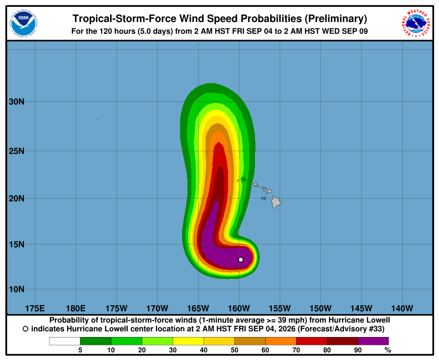
Lowell is forecast to produce rainfall totals of 3 to 6 inches, with maximum totals exceeding 10 inches possible, for Kauai, Niʻihau and the Big Island. This rainfall may produce flash flooding and mudslides, especially in areas of steep terrain.
For Maui, 2 to 4 inches of rain is expected, with isolated maximum totals of 8 inches possible. Across the remaining islands, rainfall of 1 to 2 inches with maximum amounts of 4 inches is possible.
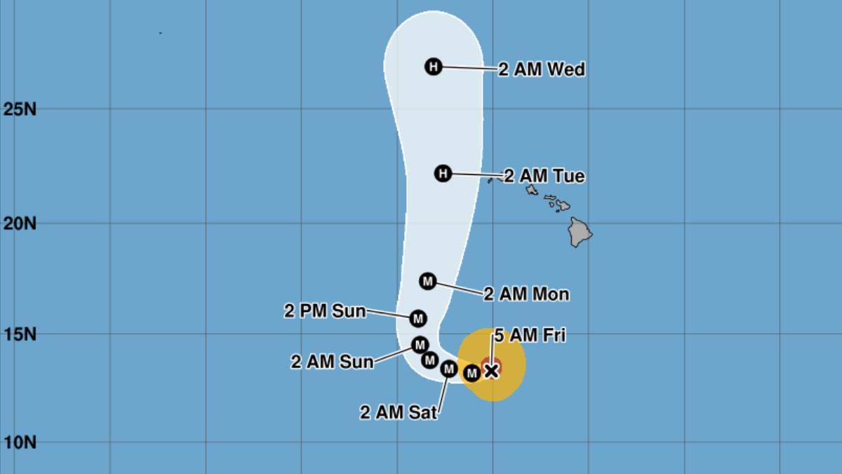
The center of Lowell was located about 600 miles south of Līhuʻe, moving west at 8 mph with sustained winds of 125 mph. Hurricane watches could be required for portions of the westernmost Hawaiian Islands on Saturday.
The storm is expected to continue west with a gradual decrease in forward speed, and then take a sharp turn to the north or north-northeast on Sunday. After this turn, it will pick up speed, bringing the system close to the westernmost Hawaiian Islands on Monday and Monday night.
Although the models all show Lowell turning, there is a notable amount of spread on how close the core of Lowell gets to Kauai County, the advisory said.
The Air Force Hurricane Hunters are scheduled to investigate Lowell on Friday, and the information they collect will be very helpful in assessing the cyclone’s intensity and structure.
Some re-strengthening of the hurricane also is forecast during the next couple of days, back to Category 4 level.
Swells from Lowell are likely to cause life-threatening surf and rip current conditions during the next several days across many of the Hawaiian islands, including Kauaʻi and Niʻihau.
While it is still too soon to determine Lowell’s exact track, the hurricane could bring storm surge, wind and rainfall impacts to portions of Hawai‘i early next week, especially Kaua‘i County.
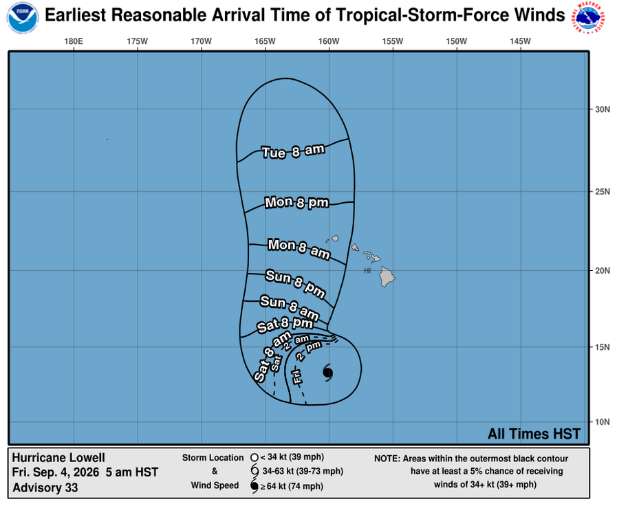
Winds are still expected to arrive by about 8 a.m. or shortly after Monday.
Hurricane force winds on Thursday night extended outward up to 45 miles and tropical storm force winds extended outward up to 140 miles from the hurricane’s center.
Swells generated by Lowell are likely to cause life-threatening surf and rip current conditions in parts of the state during the next several days and forecast to likely increase early next week.
A high surf advisory remains in effect through 6 a.m. Saturday for south and southeast exposures of all islands.
Large breaking waves are forecast to build up to 7 to 10 feet along east-facing shores, and 8 to 12 feet along south-facing shores. The swells will build up to 10 to 14 feet by Saturday, the National Weather Service advisory said.
The storm is bringing back memories for some Kauaʻi residents of the catastrophic Category 4 Hurricane ʻIniki, which in 1992 struck the island, killing seven people and doing an estimated $3 billion in damage.
Hawaiʻi County urges preparedness
Hawaiʻi County Civil Defense encourages residents and businesses to review or develop preparedness plans now, before the next storm arrives.
Contact Civil Defense at 808-935-0031 or visit the Civil Defense website if you have any questions or require assistance.
Check the Hawai‘i County Hazard Impact Map for even more information.





