


Lowell remains Category 4 hurricane; forecasters say still ‘too soon to determine potential impacts in the Hawaiian Islands’
"The details of Lowell's long-range track and intensity forecasts are more uncertain than usual," said the 11 p.m. advisory update from Central Pacific Hurricane Center; storm still expected to remain a major hurricane for next several days.
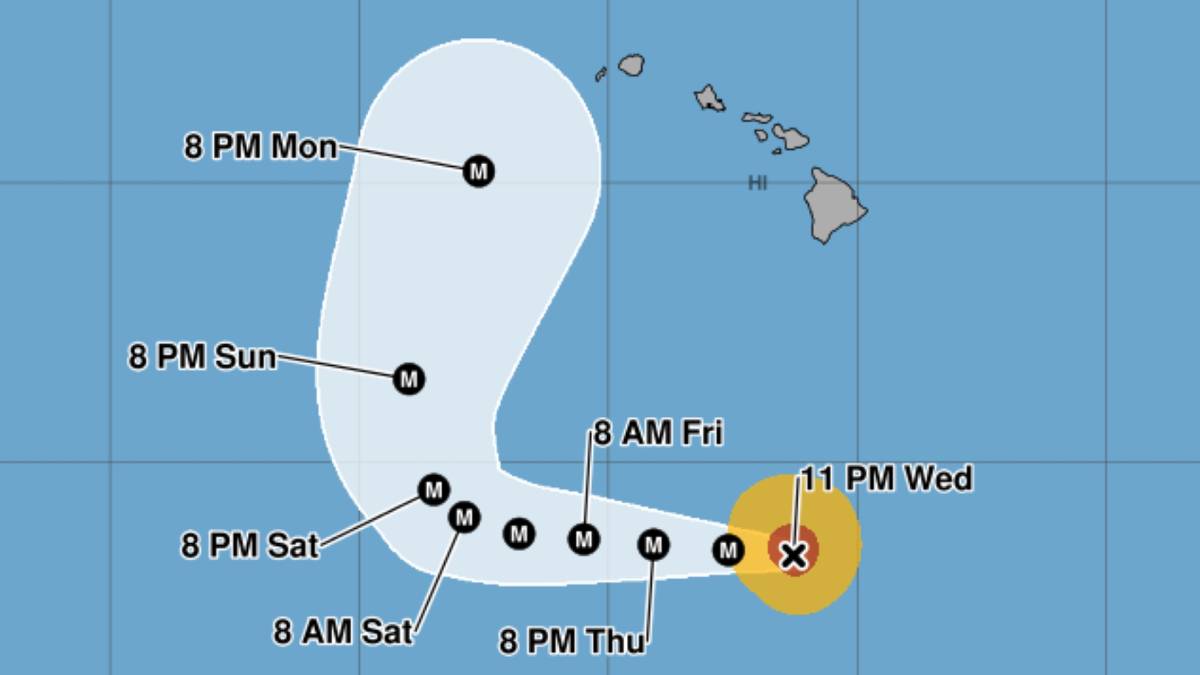
This story was updated on Sept. 3 at 12:01 a.m.
The key message from the Central Pacific Hurricane Center in its 11 p.m. Wednesday advisory update for Category 4 Hurricane Lowell reiterated that swells generated by the storm continue to spread northward and will affect portions of the Hawaiian Islands during the next several days.
The swells are likely to cause life-threatening surf and rip current conditions.
Swells generated by Lowell are spreading northward throughout the islands and affect portions of the state throughout the next several days. They likely will cause life-threatening surf and rip currents.
The National Weather Service in Honolulu issued a high surf advisory through 6 p.m. Thursday for south and southeast shorelines.
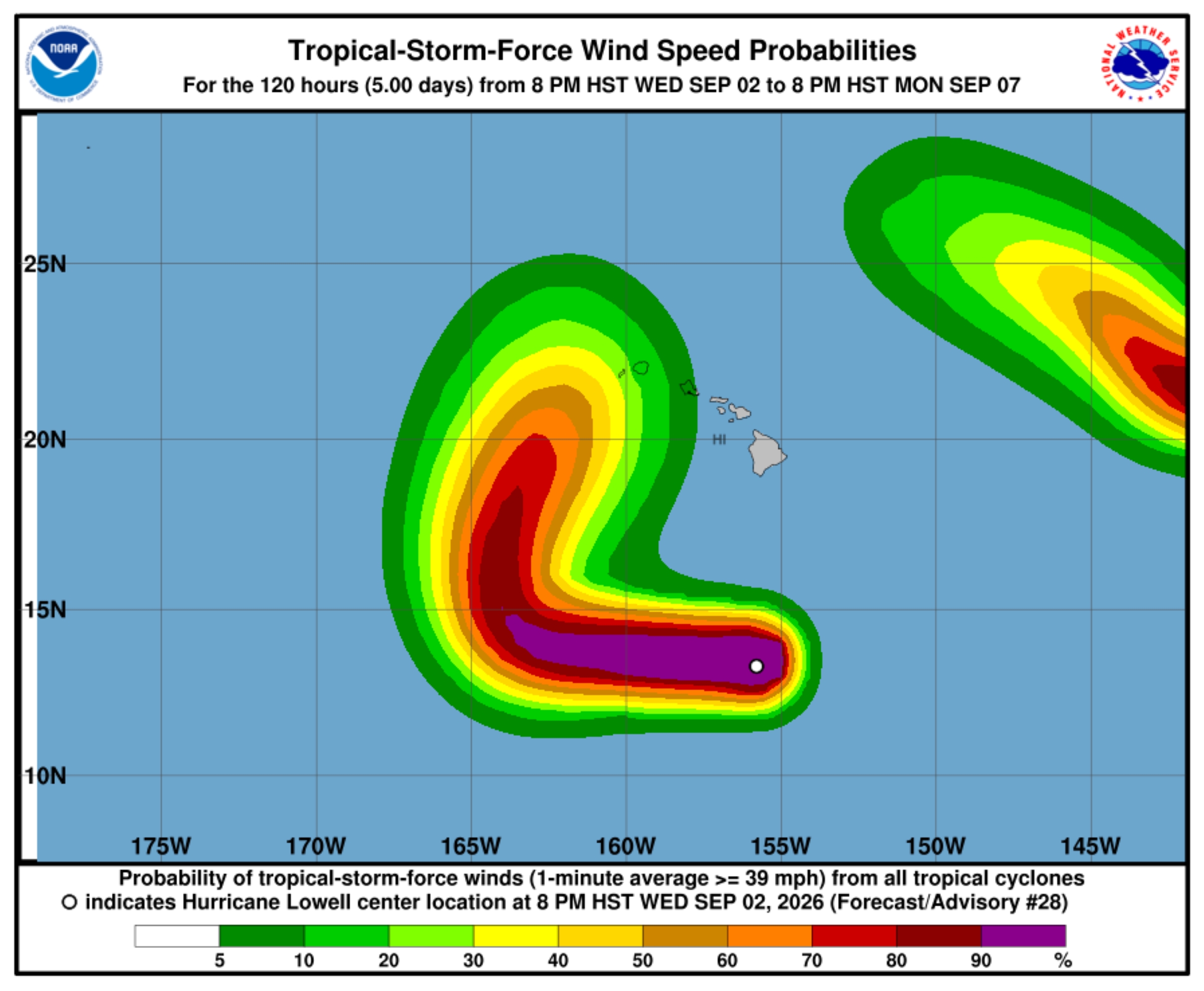
Swells from Lowell quickly filled in Wednesday, producing surf from 7 to 10 feet for southeast Big Island shorelines. Additionally, a moderate long-period south swell filled in Tuesday night, producing elevated surf along southern exposures.
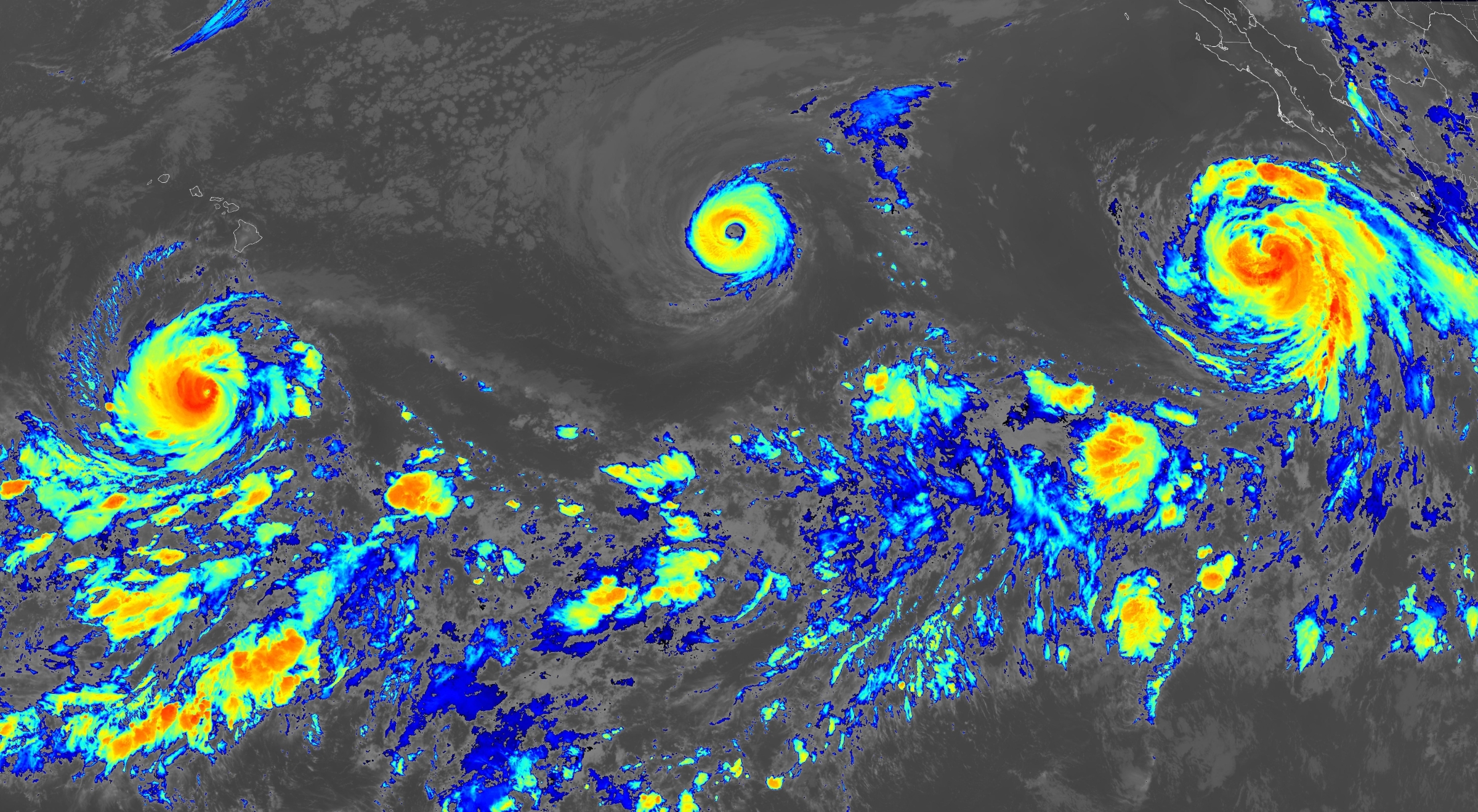
Lowell’s satellite presentation continued to weaken throughout Wednesday evening, with some thinning of the eyewall convection; however, it remains a formidable hurricane.
Central Pacific Hurricane Center forecasters said the storm is likely to remain in a low-shear, warm-water environment for at least the next few days, with “fluctuations in intensity both up and down, dependent on nearly impossible to predict eyewall replacement cycles.”
Vertical wind shear should increase some, which eventually should cause a more steady weakening.
“The details of Lowell’s long-range track and intensity forecasts are more uncertain than usual,” the hurricane center said, “and it is too soon to determine potential impacts in the Hawaiian Islands.”
Lowell again weakened slightly since the 5 p.m. hurricane center update, but is expected to remain a major hurricane for the next several days.
The center was located about 450 miles south of Hilo, exhibiting maximum sustained winds of 145 mph, with higher gusts and hurricane force winds extending up to 40 miles and tropical storm force winds extending up to 105 miles outward from the storm’s center.
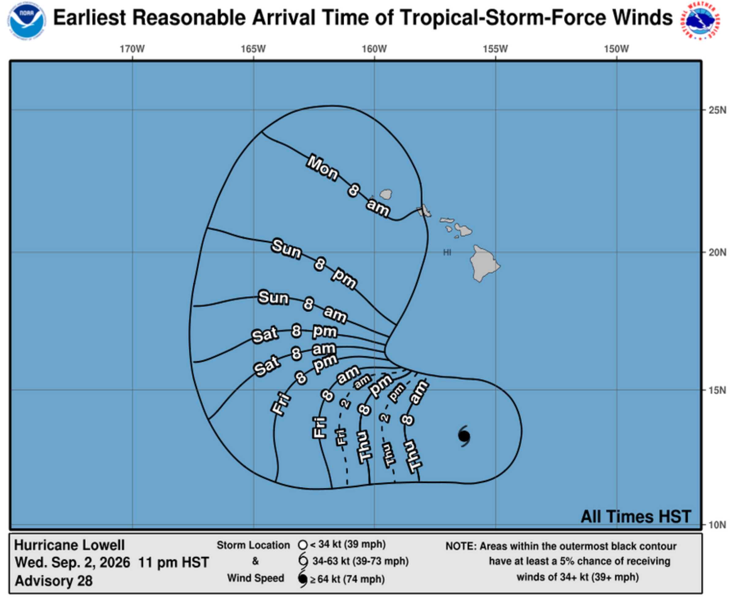
Lowell continued its westward motion still at 10 mph.
That general motion, with a gradual decrease in forward speed, is expected during the next
few days. Some fluctuations in intensity also remain expected in the near future; however, Lowell will remain a major hurricane during the next several days.
Lowell continues to be steered by a low- to mid-level ridge to the north, and because of that feature the storm should continue moving westward for the next 2 to 3 days.
After that, the track of the hurricane will be controlled by a complex developing mid- to upper-level trough seen in water vapor imagery, which is forecast to break down the ridge to the north during the weekend.
That should cause Lowell to turn sharply northward or north-northeastward; however, the details of this turn are extremely difficult to predict and there is a wide range of possibilities.
The new National Hurricane Center forecast is a bit left of the last one, but ends up very close to the previous forecast.
“Given the large spread, this is a low-confidence prediction for early next week,” said the 11 p.m. update.
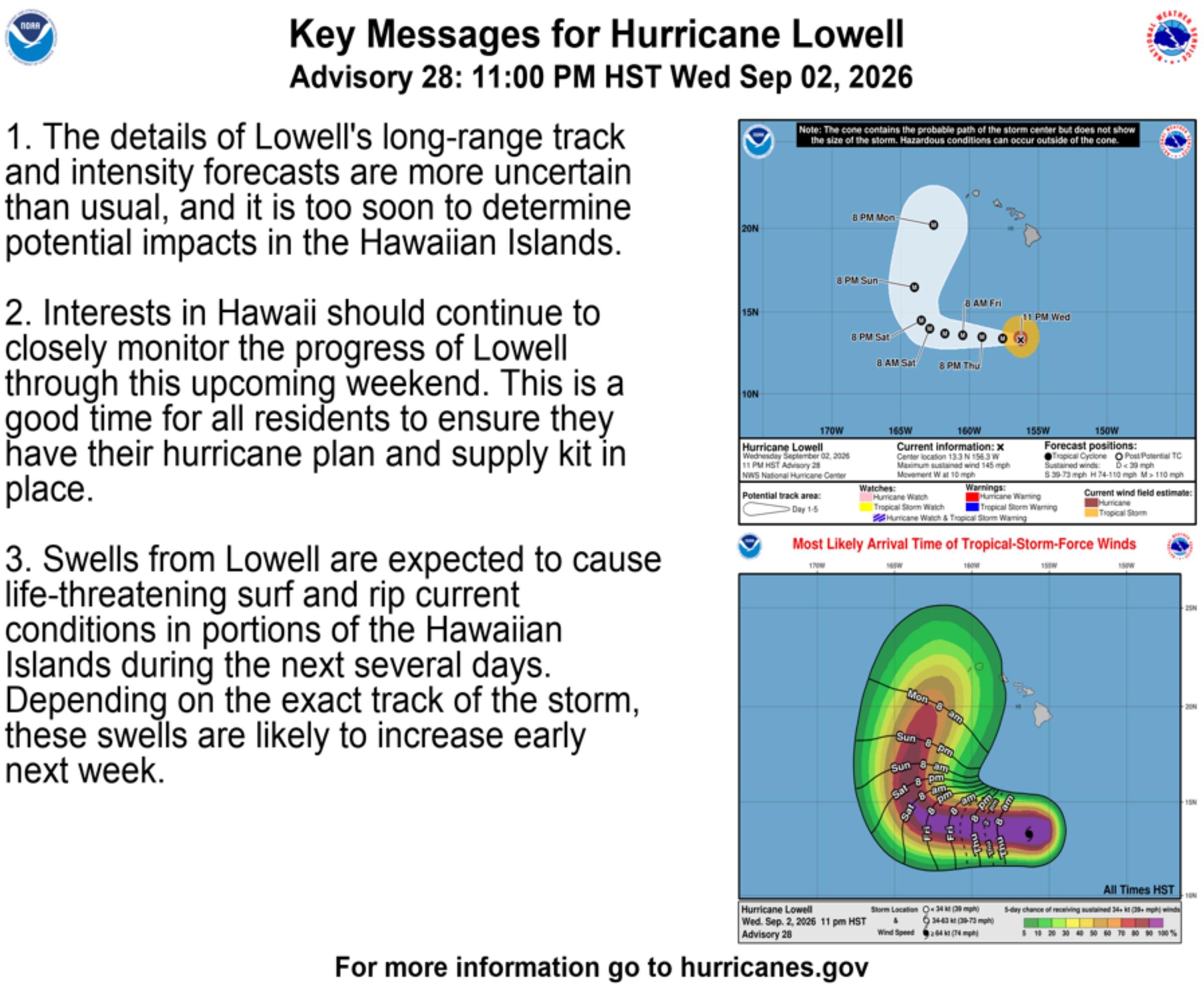
The public should pay attention to National Weather Service in Honolulu for additional forecasts, changes and any other advisories, watches or warnings are posted. Forecasts for specific locations can be found on the National Weather Service website.
No coastal watches or warnings are in effect.
Additional tropical cyclone activity to the east
There also are two storms in the Eastern Pacific: Hurricane Karina and now Hurricane Marie.
Hurricane Karina weakened more Wednesday evening. It is now a Category 3 hurricane with maximum sustained winds of 120 mph. It was about 1,260 miles east of Hilo, moving west-northwest at 12 mph.
Gradual weakening is expected to continue; however, Karina is expected to remain a hurricane for the next couple of days.
Tropical Storm Marie became Category 1 Hurricane Marie on Wednesday afternoon and continues to gradually increase strength. It was located about 380 miles southwest from the southern tip of Baja California, moving west-northwest at 10 mph.
Hurricanes Karina and Marie are not expected to present any severe weather impacts to the state, and continue to be monitored closely.
Hawaiʻi County Civil Defense encourages residents and businesses to review or develop preparedness plans now, before the next storm arrives.
Contact Civil Defense at 808-935-0031 or visit the Civil Defense website if you have any questions or require assistance.
Check the Hawai‘i County Hazard Impact Map for even more information.





