


Tropical Storm Moke weakens slightly Saturday afternoon; however, little change in strength, forecast expected tonight
Updated 6:43 p.m. Saturday, Aug. 22
Tropical Storm Moke weakened slightly Saturday afternoon, now with maximum winds of 45 mph as of the 5 p.m. advisory from Central Pacific Hurricane Center, down from 50 mph as of late morning.
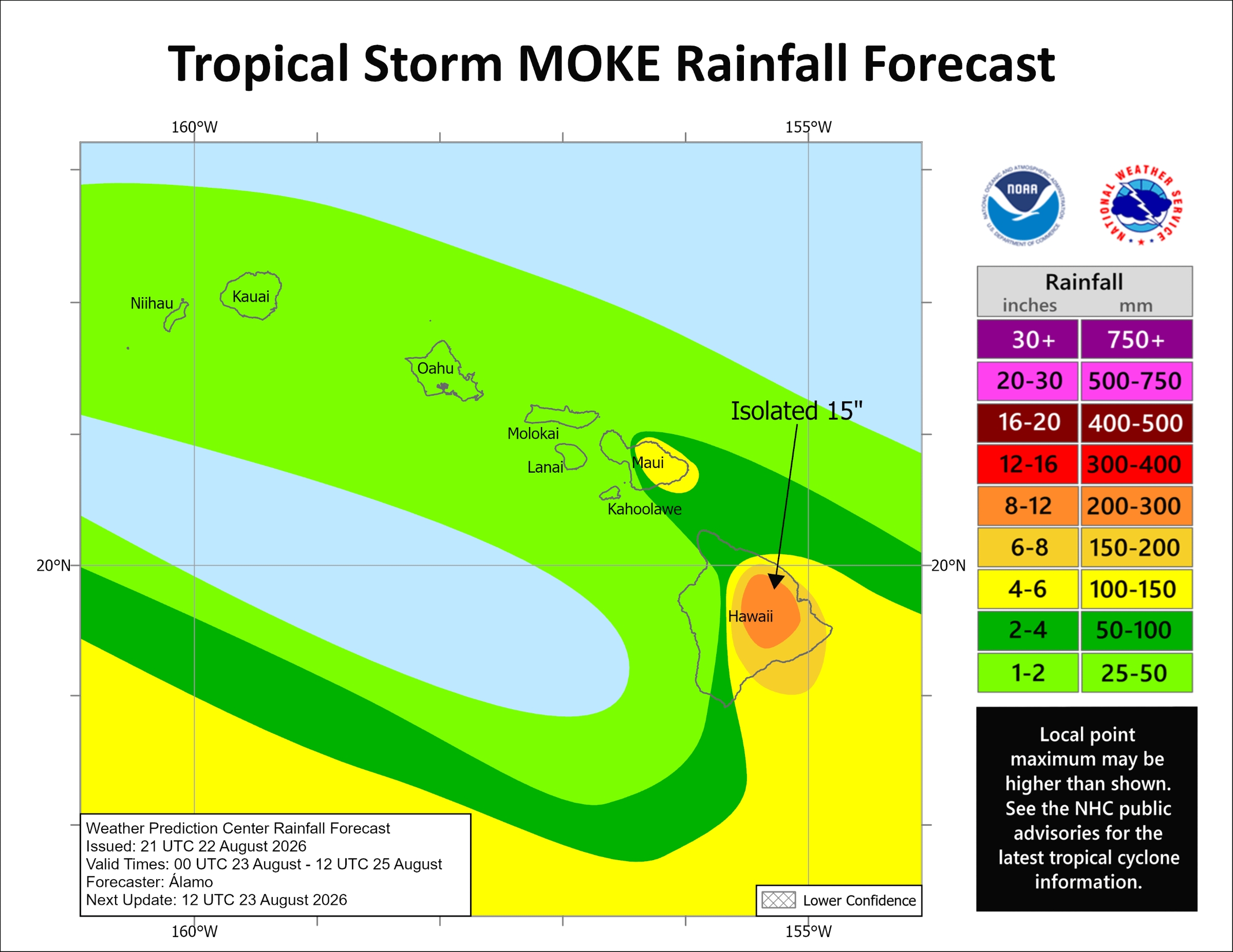
However, while little change in strength is expected tonight and more of a weakening trend to begin Sunday, the threat of 5 to 10 inches of rain, with up to 15 inches in some localized areas, remains for windward and southeast portions of the Big Island.
That heavy rainfall could cause life-threatening flooding and mudslides, especially in areas impacted a week ago by Hurricane Lala.
Strong enhanced trade winds caused by a pressure gradient created by the storm as it passes a couple of hundred miles to the south of the Big Island also remain possible at high terrain and downslope, including many locations still suffering from Lala impacts as well.
The strongest winds will blow tonight through Sunday night from 25 to 35 mph, with gusts up to 55 mph. There is even a chance gusts could approach high wind warning criteria of 58 mph or stronger in the normally windiest spots in leeward Kohala and near South Point.
Areas of concern include Kaʻū, lower Puna, Hāmākua Coast and Kohala.
A flood watch is in effect from midnight Sunday through Monday for the island, plus a wind advisory went into effect at noon today for mainly leeward locations in the north, south and southeast areas of the island.
Windward Maui is forecast to see 2 to 4 inches of rain with locally higher amounts. The rest of the state is still expected to receive about 1 to 2 inches of rain, with some amounts higher in localized areas.
Confidence in the heavy rainfall potential and flooding is highest for the Big Island.
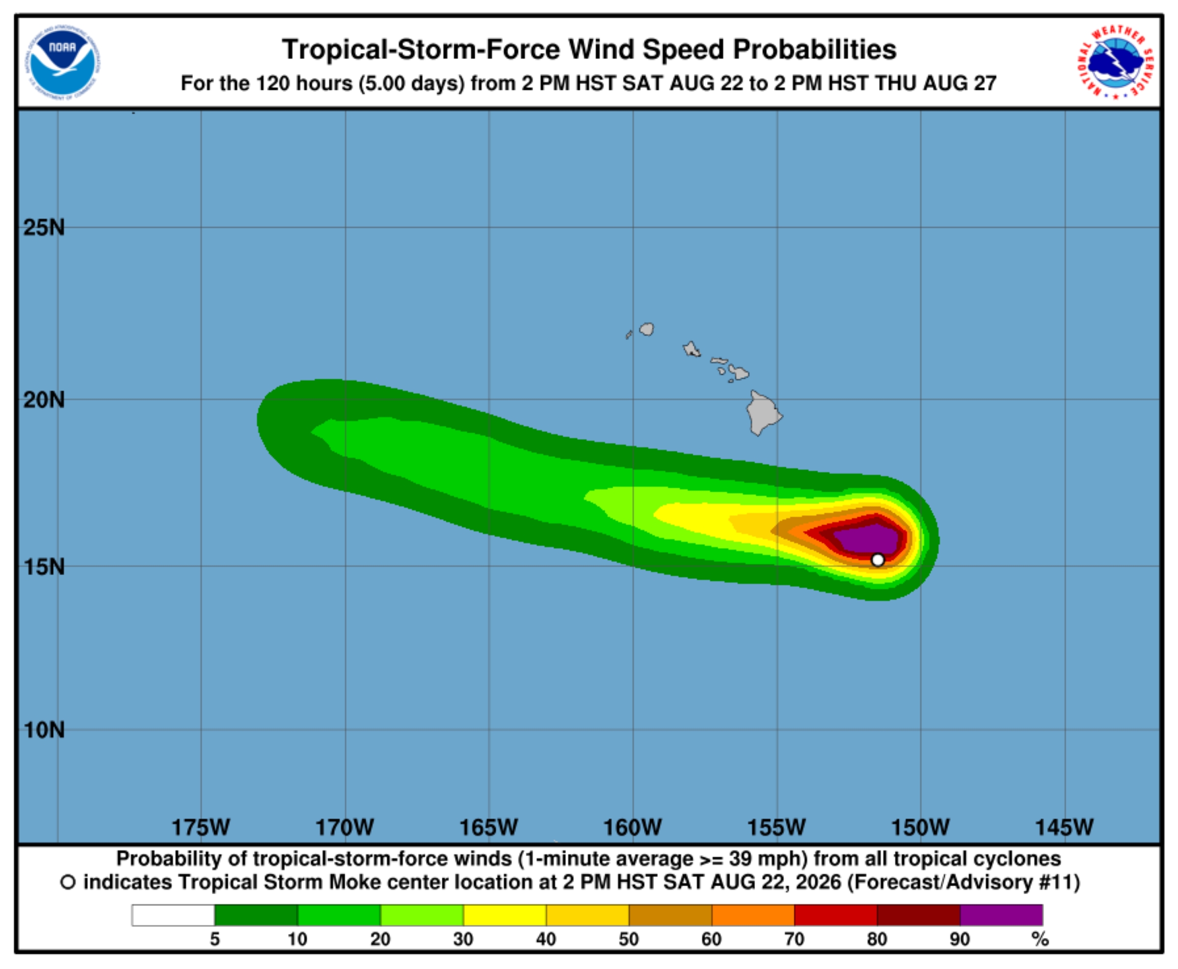
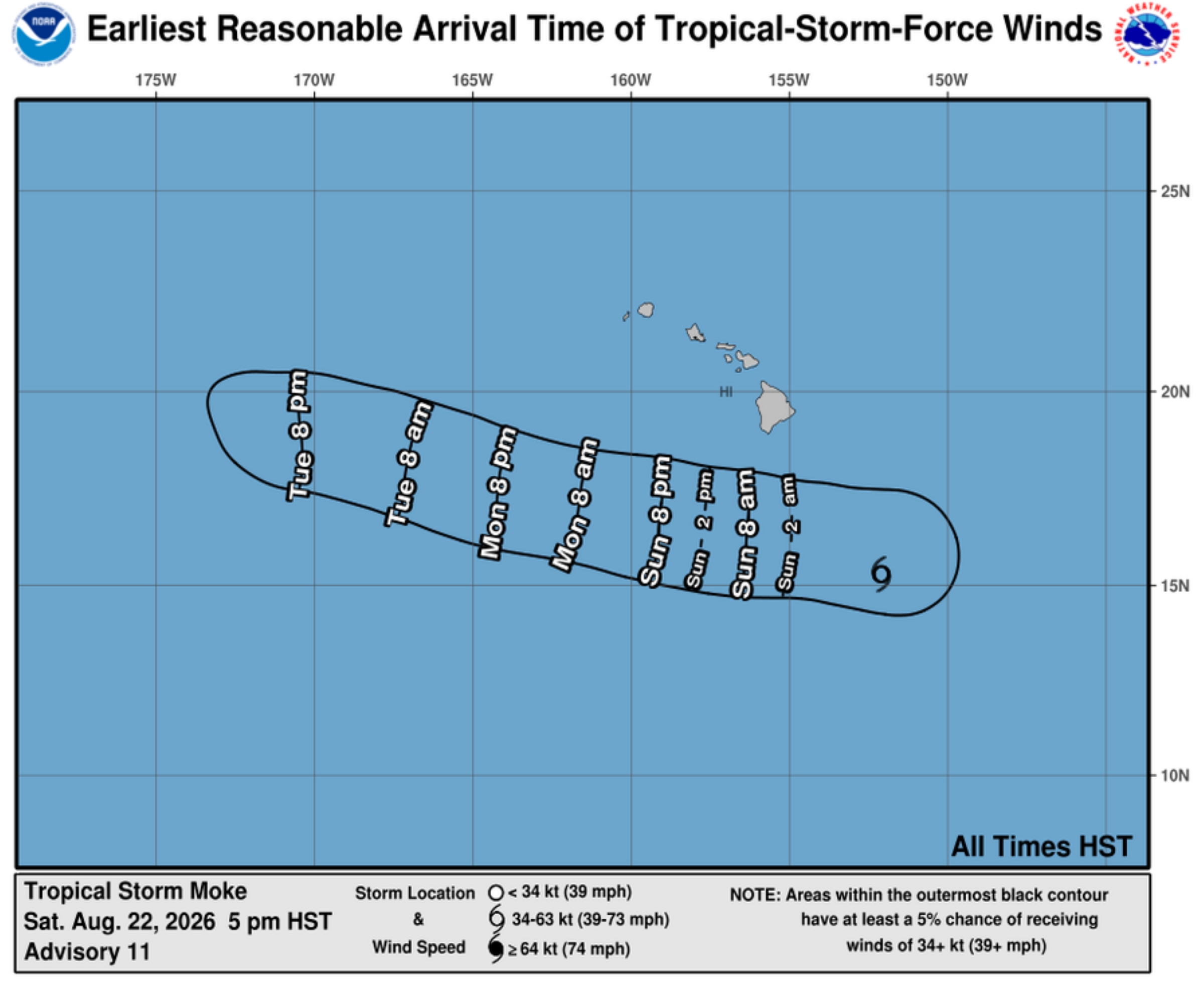
Moke was about 360 miles south-southeast of Hilo as of the 5 p.m. update, moving west at 14 mph. No tropical storm watches or warnings are expected because of the compactness of the storm and how far winds from the storm itself will stay south of the islands.
That general motion is expected during the next several days, with the storm’s center expected to pass south of the Big Island on Sunday and then well-south of the the smaller main Hawaiian Islands early next week.
Tropical storm force winds extended about 115 miles outward from Moke’s center.
More from the forecast
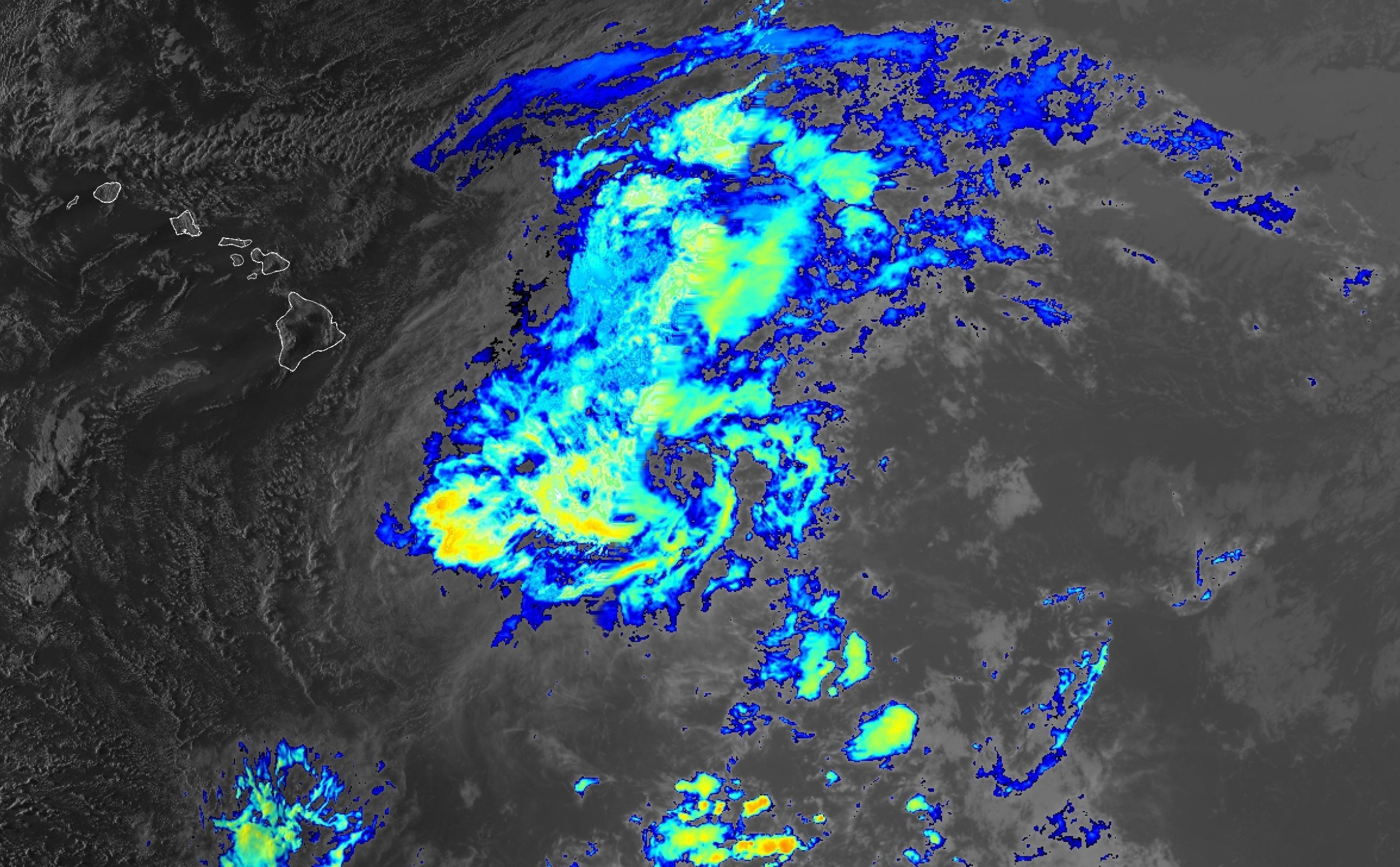
Persistent deep convection that was previously located over and north of the storm’s circulation overnight Friday and through the morning hours Saturday largely collapsed, with Moke’s cloud tops warming noticeably.
The deterioration appears to be, at least in part, because of ongoing southwesterly vertical wind shear and dry mid-level air.
A low- to mid-level ridge strengthening to the north of Moke will continue steerings it in that continued west-northwest direction, eventually moving into an increasingly drier and stable environment that will lead to the storm’s gradual weakening trend.
Moke could degenerate into a remnant low by Wednesday.
The next complete advisory for Tropical Storm Moke will be issued at 11 p.m. today by Central Pacific Hurricane Center.
Updates from Hawai‘i County
“Our county crews remain ready to respond, and we ask our residents to remain vigilant and be prepared for heavy rainfall and gusty winds as Tropical Storm Moke passes us to the south,” said Hawai‘i County Mayor Kimo Alameda in a noon Saturday update from the county. “The ground remains saturated, so be aware it may not take much rain to cause more flooding.”
Alameda acknowledged Big Island residents are fatigued and still recovering from Hurricane Lala, and he thanked everyone for doing their part to keep themselves and their neighbors safe.
All preparations should be completed essentially now.
Power and communication outages should be anticipated, as well as hazardous road conditions.
Those in flood prone areas, especially those impacted by Hurricane Lala, are advised to prepare for possible additional flooding impacts and consider evacuating the area before storm conditions begin.
Shelters will be open as of 8 p.m. Saturday, with those at Nāʻālehu Elementary School gym and Robert N. Herkes Gym in Pāhala already open and operating with generator power.
Shelter locations:
- Nāʻālehu Elementary School gym, 95-5545 Māmalahoa Highway, Nāʻālehu.
- Robert N. Herkes Gym, 96-1219 Kamani St., Pāhala.
- Pāhoa Senior Center, 15-3016 Kauhale St., Pāhoa
- Keaʻau Armory, 16-512 Volcano Road, Keaʻau.
- Puʻuʻeo Community Center, 145 Wainaku St., Hilo.
- Sgt. Rodney J.T. Yano Memorial Hall, 82-6156 Māmalahoa Highway, Captain Cook.
Anyone who comes to a shelter should bring their own supplies, including food, water, sleeping bags and any necessary medicine. Shelters are pet friendly; however, pets must be kept in a carrier.
Hot showers are available at Robert N. Herkes Gym. Bring your own towels and hygiene products.
Bus service
The following Hele-On bus routes are canceled Sunday:
- Routes 2, 10, 12 and 90.
- Route 75 at 6:15 a.m. (southbound to Kona)
- Route 75 at 3:03 p.m. (northbound to Kapaʻau).
All other fixed route services and trip times are scheduled to operate as regularly scheduled; however, because of the unknown effects of weather conditions, transportation delays, re-routing and cancellations could occur at a moment’s notice.
The Hilo park and ride spot on Kamehameha Avenue will be moved to the Kuawa Park parking lot if Kamehameha Avenue floods.
Sandbags
Sandbags can be requested by contacting Hawaiʻi County Civil Defense at 808-935-0031. Sandpile locations can be found online. Bring your own sandbags.
Hawaiʻi County Department of Public Works completed clearing the Nāʻālehu flood channel Friday as part of preparations for Tropical Storm Moke.
Highway 11 will be open to area residents only between the entrance of Hawaiʻi Volcanoes National Park and Kaʻū in the event the next lava fountaining episode of the ongoing episodic Kīlauea summit eruption happens during the storm.
Access to Pāhala and Waiʻōhinu/Nāʻālehu via Highway 11 remains limited to local/disaster response only.
General safety information
- Complete storm preparations, have a shelter plan and avoid unnecessary travel by staying off roadways during storm impacts.
- Know the areas prone to flooding, especially near your home, and use extra caution around them. Heavy rain uphill from your location can cause flooding, even if it’s not raining where you are.
- Never try crossing moving water, on foot or in a vehicle: “Turn around, don’t drown.”
- Have a “go bag” ready in case you must evacuate, especially if your home is in an area prone to flooding. It should include food, water, necessary medication, important documents and other necessities for the members of your household (including pets) if you need to leave in a hurry.
- Check the area around your home. Trim tree limbs and secure awnings, umbrellas and other objects that could become airborne and damage your roof or windows. Remove debris that could block drainage and increase the chance of flooding.
- Check in with neighbors, especially those who might have mobility problems, to make sure they have a safe way to evacuate if flooding strikes.
Monitor local radio broadcasts for additional updates and official advisories in your area.
Contact Civil Defense at 808-935-0031 or visit the Civil Defense website for additional information or with any questions. The site also includes tropical cyclone resources.
Be sure to check the Hawai‘i County Hazard Impact Map for information about impacts and hazards from the storm.
Hawaiian Electric
Hawaiian Electric urges customers to review their emergency plans, ensure they have supplies on hand and to closely monitor weather updates.
Preparation and safety tips are available on the Hawaiian Electric website, and detailed tips also can be found in the utility’s Handbook for Emergency Preparedness.
Click here or download the utility’s mobile app for the latest outage information and estimated time of restoration.
Hawaiian Electric resources for updates and more information:
- Hawaiian Electric website.
- X: @hielectriclight
- Facebook.
- Mobile app: Free download available from The App Store for Apple devices and Google Play for Android devices.
Hawai‘i Department of Transportation preparations
Crews on all islands Friday prepared facilities and worked to remove vegetation from streams and saturated hillsides in preparation for heavy rainfall from Tropical Storm Moke.
Debris washed into streams by Lala and all previous storms also was removed at mileposts 50, 51.5, 53.5, 54.5 and 56.5. All bridges along Māmalahoa Highway (Highway 11) in Ka‘ū impacted by Lala were inspected and found structurally sound and safe.
Crews reinspected drainage, trimmed trees to remove potential hazards, secured equipment, tied down or relocated aircraft and topped off emergency power generators at Hilo International and Ellison Onizuka Kona International airports.
More from the state
State agencies remain ready to respond to Tropical Storm Moke and support county emergency response efforts. State personnel and resources are on standby to address possible impacts.
“State and county teams are ready to respond and I urge everyone to remain alert, follow official updates and avoid unnecessary risks as the storm passes,” said Hawai’i Gov. Josh Green in a state release.
Hawaiʻi National Guard continues was preparing additional personnel and resources for Tropical Storm Moke, with 153 personnel positioned statewide. Task Force Hawaiʻi has 76 personnel supporting Hawaiʻi County, with five high-wheeled vehicle teams and three aviation crews ready.
Parks closed because of Hurricane Lala will remain closed through the weekend. Kekaha Kai, Wailuku River, ʻAkaka Falls and MacKenzie state parks remain open but are prepared to close Sunday. Keanakolu and Ainapo cabins and the Puna Trail are closed.
Refunds for canceled camping and lodging permits will be credited to permit holders who miss camping nights because of storm closures.
Storm-related closures and status of state-managed lands are available at the Hawaiʻi Department of Land and Natural Resources website.
State small boat harbors and their restrooms remain open, subject to available mooring space and vessel size, to provide safe harbor. Boat owners and operators should check moorings and lines, bilge pumps, cabins and hatches and take precautions to protect themselves, their vessels and natural resources.
Vessel groundings should be immediately reported to the state Division of Boating and Ocean Recreation.
Hawaiʻi Department of Law Enforcement is standing by to provide security support for state shelters. Department drones also are on standby for deployment, if needed, to identify areas of concern.
Hawaiʻi state health officials continue to monitor health and medical operations statewide.
Air medical and ground EMS services are operating normally statewide and hospitals are operating at normal capacity. The Medical Operations Coordination Center continues to monitor 9-1-1, EMS, air medical services, hospitals and the Healthcare Emergency Management Coalition.
The 10 University of Hawaiʻi campuses also continue to monitor the storm and its potential impacts. The fall semester begins Monday with the first day of classes.






