


UPDATE: High surf warning continues as Fausto downgrades to tropical storm
Update at 5 p.m. Monday, July 27: Significant surf is expected for Hawaiʻi as the National Weather Service downgrades Fausto to a tropical storm.
Forecasters indicate that surf will continue to build westward across Hawaiʻi along exposed east-facing shores through Tuesday as Tropical Storm Fausto approaches and begins to pass north of the islands. Large surf and strong currents will lead to dangerous conditions along exposed shores.
Due to high surf warning conditions, the County of Hawaiʻi has closed the following Keaukaha beach parks in Hilo:
- Onekahakaha Beach Park
- Kealoha Beach Park
- Carlsmith Beach Park
- Leleiwi Beach Park
- Waiʻōlena Beach Park
- Waiuli Beach Park
- Richardson’s Ocean Park
- Lehia Beach Park
- Lālākēa Beach Park
The Hawaiʻi County Civil Defense Agency will update the county as conditions change. For more information, visit the County of Hawaii Hazard Impact Map.
Original story at 8 a.m. Monday, July 27: A high surf advisory for east-facing shores of the Hawaiian Islands has been upgraded to a warning as Hurricane Fausto approaches.
Hurricane Fausto will bring surf of 12 to 16 feet, building today and peaking on Tuesday. Areas on Hawai‘i Island impacted by the surf include North Kohala, Hāmākua, North Hilo, South Hilo and Puna Districts through Wednesday.
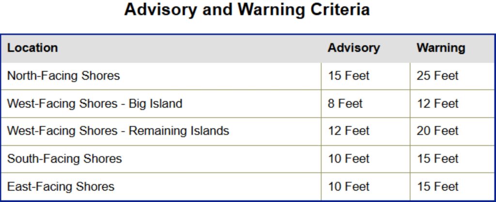
The public is advised to heed all advice from ocean safety officials. Remember: when in doubt, don’t go out.
A tropical storm warning also is in effect for Hawaiian offshore waters beyond 40 nautical miles to 240 nautical miles — or about 46 miles to about 276 miles — including the portion of Papahānaumokuākea Marine National Monument east of French Frigate Shoals
Seas given as significant wave height, which is the average height of the highest one-third of the waves. Individual waves could be more than twice the significant wave height.
Meanwhile, the high surf advisory previously in effect for south-facing shores throughout the state was canceled as surf dropped below advisory levels along those shorelines.







