

2,000 acres in lower Puna transformed by 2018 lava flow now on a path to preservation
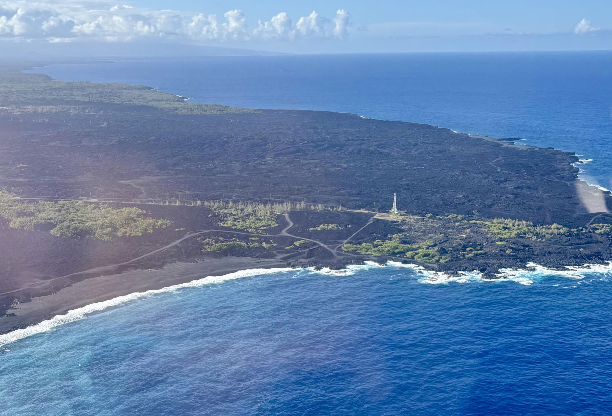
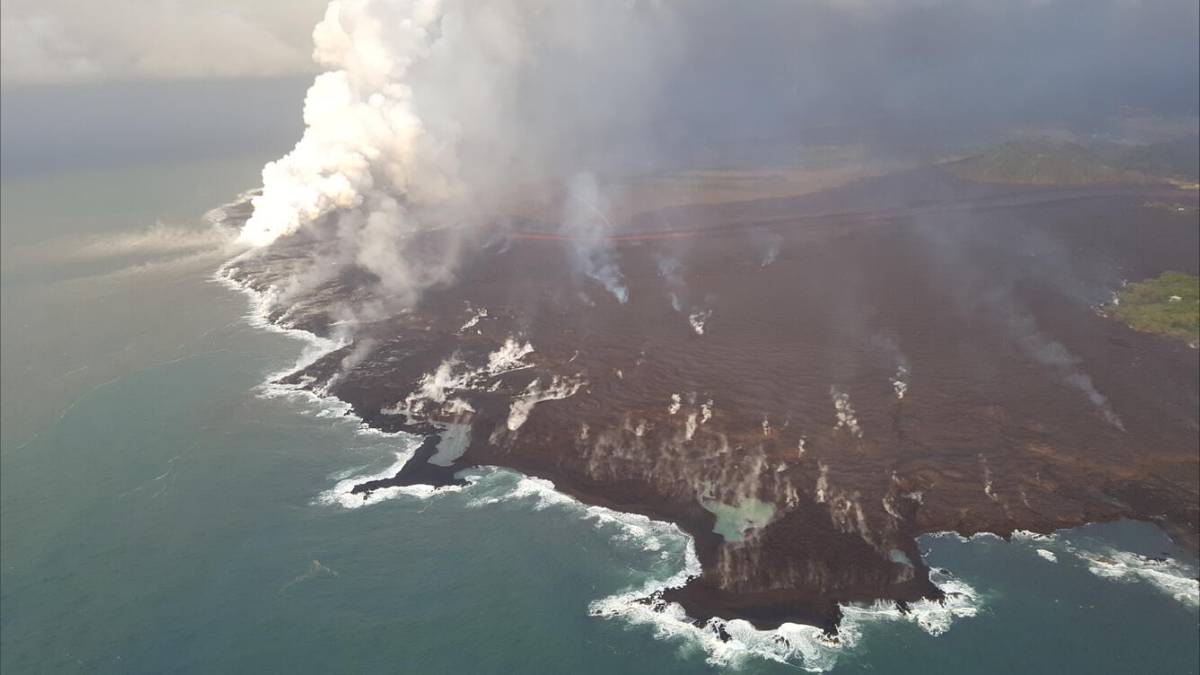
During the eruption of Kīlauea eight years ago, flowing lava destroyed two communities as it transformed thousands of acres of land at the easternmost point of the Hawaiian Islands.
On Tuesday morning, the Hawaiʻi County Council passed Resolution 516-26 that directs the county finance director to enter into negotiations with seven lower Puna landowners to acquire properties collectively encompassing 1,967 rocky coastal acres known as “Kumukahi” through Public Access, Open Space and Natural Resources Preservation funds.
These funds come from a County of Hawaiʻi initiative that uses property taxes to acquire lands for public use and conservation. The goal is to preserve historic, culturally significant areas; protect coastal environments, forests and beaches; and manage the land for public outdoor recreation.
The Kapoho and Vacationland communities sit within Kumukahi, which holds great natural and cultural significance. However, the Kīlauea eruption of 2018 reshaped the landscape and covered these communities completely, destroying hundreds of homes as well as a large section of Highway 132.
While much of Highway 132, including the junction with Highway 137 (known as the Four Corners), reopened in 2019, the section leading to Kumukahi has not reopened, and there is no public vehicular access.
According to the County Council, the need to establish stewardship and management of the landscape is increasing as visitors access Kumukahi by traversing through private property. The reconstruction of the 0.15-mile section between the Four Corners and Kumukahi is scheduled for completion by December 2026.
“Preserving this special place and establishing long-term, locally-rooted stewardship of the area is of critical importance, and every single property owner is on board,” Councilmember Ashley Kierkiewicz said during the meeting.
With known burial sites and heiau (sacred places of worship), Kumukahi bears great cultural significance as a wahi pana (legendary place) and wahi kūpuna (ancestral place). It is also where the sun first rises in all of Hawaiʻi, representing beginnings and transitions.
Before the council could vote on the resolution, a community member began speaking outside the bounds of testimony, insinuating that the public was not given time to testify.
However, this claim was unfounded, as community members were notified of the resolution as a County Council agenda item, and there were testifiers before the vote during the Committee on Legislative Approvals and Acquisitions meeting on April 21.
“At a time when government trust is low, I want the public to be assured that the appropriate and legal notification timelines have been followed,” Councilmember Rebecca Villegas said after the interruption. “The community has time to lean in and testify, but there are strict deadlines and timelines for us to receive that testimony.”
The Hawaiʻi County Council voted unanimously to allow the finance director to also initiate funding mechanisms required to acquire Kumukahi, identified under the Tax Map Key numbers: 1-4-002:002, 017, 042, 047, 048, 052, 065, 072, 080, 081, 082, 085, 092, and 100.
“Recognized lineal descendants of the area and ʻohana (family) of the area have been engaged, and the public record of testimony reflects their support,” Kierkiewicz said. “This property belongs to the public in perpetuity, and we are looking to locally-rooted stewardship for future land management.”
No dollar figure was included in the resolution, but a supporting county document said that all current landowners have been involved in discussions about consolidated ownership of Kumukahi for protection in perpetuity and a “considerable number of these landowners have expressed a willingness to sell or donate their properties.”
The document said Kapoho Land & Development, Kumukahi Properties and the Roseanne Oda-Ching Trust have expressed a willingness to sell. It alo said the Lorraine Lorretta Tobin Trust and Frank Cole & Thomas Tobin (Tobin property interests) have expressed an openess to sell or establish a conservation easement.
There also is state-owned land involved. It is not clear if this can be included.
Once the land is secured, the properties will be consolidated under a single community management and stewardship plan led by descendants and community-based nonprofits in Puna.
According to the proposed vision in the resolution, the long-term goals of the acquisition are to reinforce education about the land through cultural programming such as traditional fishing, astronomy, cosmology, wayfinding, storytelling and other significant cultural traditions.
Through these efforts, access to Kumukahi can be a privilege and a responsibility rather than an entitled right.
“Intentional, locally-rooted stewardship will help prevent any further encroachment on these lands by development,” Kierkiewicz said. “Any inappropriate use and access, as well as the introduction of non-native and invasive species to its coastlines, could lead to the degradation of this beloved place.”
Sponsored Content


