

Volcano Watch: Shallow earthquakes, ground deformation at Kīlauea’s summit highlight hazards near Halemaʻumaʻu

The Hawaiian Volcano Observatory detected an increase in shallow seismicity and localized ground deformation beneath the south rim of Halemaʻumaʻu crater, in Kīlauea summitʻs south caldera region.
This activity highlights the dynamic and hazardous nature of the closed area in Hawaiʻi Volcanoes National Park, where changes can occur quickly, resulting in rapidly escalating hazards.
Over the past several months, instruments of the observatory have recorded ongoing shallow earthquakes beneath the south rim of Halemaʻumaʻu.
During the past week, an additional 30 magnitude‑2 and smaller earthquakes occurred at depths of roughly 0.6–1.8 miles beneath the surface. As is typical for seismicity at this scale, most events are too small to be widely felt.
Deeper earthquakes beneath the broader summit region also have continued, but these have been characteristic of activity throughout the ongoing eruption.
This recent activity follows a discrete swarm of 15 shallow earthquakes—also magnitude‑2 or smaller—detected beneath the same area during the final hours of episode 44 on April 9.
While most of those events were imperceptible to the general public, several were felt by observatory staff monitoring the eruption from the crater rim.
Data on ground deformation — changes in shape due to stress, force or heat — were collected immediately after episode 44 show that an area along the south rim rose by several inches, although the specific cause of that uplift remains uncertain.
A blanket of tephra (volcanic debris) obscures the ground surface, making it difficult to determine whether cracking or subtle structural changes accompanied this deformation.
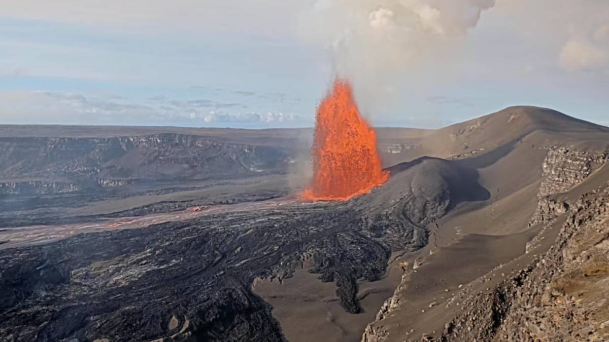
Observatory scientists paid close attention to these shallow events as episode 45 of the Halemaʻumaʻu eruption approached and erupted on April 23 for 8.5 hours. Earthquake activity during episode 45 was minor, and did not include a repeat of the seismicity observed at the end of episode 44.

COSMO-SkyMed Second Generation interferogram for the period from April 1 to April 9, 2026, covering Kīlauea volcano’s summit region. Each color fringe represents 0.61 inches of ground movement in the direction between the satellite and the ground (range change). The symbol in the upper left indicates the satellite’s orbit direction (arrow) and look direction (bar). Earthquakes are marked with circles with the size proportional to their magnitude. The lava flows covering the crater floor are represented by the pink polygon, the two vents (circles) and the Episode 30 fissure (line) are marked in light pink. (Sources/Usage: Public Domain. View Media Details)
Interestingly, the episode 44 patterns echo similar changes observed earlier in the eruption sequence. During the lead‑up to episode 30 on August 6, 2025, earthquakes and deformation in this same region were associated with the opening of a short‑lived fissure on the south side of Halemaʻumaʻu crater.
In that case, earthquakes occurred minutes to hours before the fissure began erupting, which demonstrated the potential for shallow seismicity to precede rapid changes in eruptive behavior.
This part of the south rim has experienced additional impacts during the ongoing eruption. On December 6, 2025, during episode 38, molten and hot tephra began falling into the area when the south vent lava fountain suddenly angled southward due to a change in the vent geometry.
The redirected fountain destroyed the original V3 livestream camera, which had been positioned to monitor activity from the south rim. The video documenting the camera’s destruction remains a vivid illustration of how quickly hazards can escalate in this environment.
While the Hawaiian Volcano Observatory maintains a network of monitoring cameras in the area, these instruments are placed specifically to provide awareness without requiring staff to enter hazardous zones. Their placement underscores that even trained scientists limit their exposure in areas where instability, activity and rapid change are all expected.
The closed area around Halemaʻumaʻu crater and Kīlauea summit caldera will continue to pose significant risks as the eruption evolves. Although these changes are relatively small in scale, they provide another reminder of how dynamic — and hazardous — this portion of Hawaiʻi Volcanoes National Park remains.
Conditions in and around the closed area at the summit can evolve quickly, sometimes with little warning, and these changes can elevate the risk of rockfalls, ground cracking and other potentially life‑threatening hazards.
For park visitors, the message remains simple: heed all Hawaiʻi Volcanoes National Park closures and guidance.
The area immediately surrounding Halemaʻumaʻu and the broader Kīlauea caldera walls are susceptible to wall instability and earthquake‑triggered rockfalls. If you are near the caldera rim in areas that are open to the public and you feel the ground shaking, move away from the edge immediately. Even small earthquakes can dislodge rocks or destabilize loose material.
These ongoing observations underscore the value of staying informed and maintaining awareness of activity happening at the summit of Kīlauea, especially if you live nearby or are planning to visit.
Volcano Activity Updates
Kīlauea has been erupting episodically within the summit caldera since December 23, 2024. Its USGS Volcano Alert level is ADVISORY.
Episode 45 of summit lava fountaining happened for 8.5 hours on April 23. Summit region inflation since the end of episode 45 indicates that another fountaining episode is possible; however, more time is needed to collect data to generate the model to forecast episode 46. No unusual activity has been noted along Kīlauea’s East Rift Zone or Southwest Rift Zone.
Mauna Loa is not erupting. Its USGS Volcano Alert Level is at NORMAL.
No earthquakes were reported felt in the Hawaiian Islands during the past week.
HVO continues to closely monitor Kīlauea and Mauna Loa.
Please visit HVO’s website for past Volcano Watch articles, Kīlauea and Mauna Loa updates, volcano photos, maps, recent earthquake information, and more. Email questions to askHVO@usgs.gov.
Editor’s Note: Volcano Watch is a weekly article and activity update written by Hawaiian Volcano Observatory scientists and affiliates with the U.S. Geological Survey.
Sponsored Content


