

More heavy rain, flooding, thunderstorms looking more and more likely this week for Hawai‘i
This week is a big one for the Big Island.
It’s Merrie Monarch Week, and Hilo is in the spotlight hosting the 63rd annual festival that celebrates all things Hawaiian, culminating with the “Super Bowl of Hula,” 3 nights of hula competition at Edith Kanaka‘ole Multi-Purpose Stadium.
Kīlauea volcano is also on the verge of Episode 44 of lava fountaining in its ongoing episodic summit eruption within Hawai‘i Volcanoes National Park. Hawaiian Volcano Observatory predicts it can happen anytime now, from April 6-14. Precursory activity is already underway.
Thousands of people are visiting the island from around the world.
So why wouldn’t the weather want to act up now?
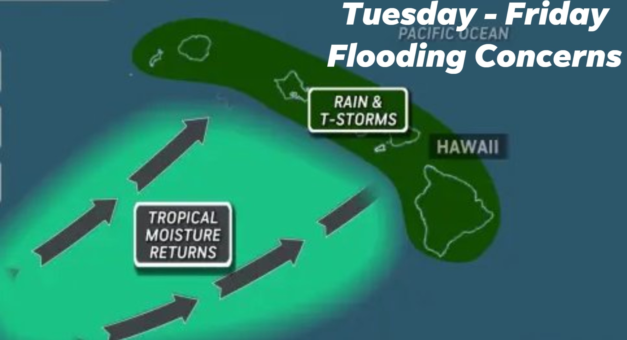
“We wanted to give an initial ‘heads-up’ that the latest forecast models continue to show the potential for a heavy rain event for the state of Hawai‘i starting around the middle of next week, potentially lasting into the next weekend,” wrote the National Weather Service Honolulu Forecast Office in an April 2 email.
That’s right. More inclement weather such as additional heavy rainfall leading to flooding and thunderstorms is again brewing even as many parts of Hawai‘i — including some on the Big Island — continue to recover after being pummeled by back-to-back kona lows in March.
Incredibly, for the fifth time since the beginning of the year, another possible kona low or kona low-like storm also could slam into the islands by next weekend.
“Friday and Saturday models indicate a stronger kona low sets up to our west, adding colder air aloft, low level converging winds and upper level diverging winds,” wrote chief citizen meteorologist and administrator of the Puna Weather group on Facebook Harry Durgin in his Sunday, April 5, forecast. “Despite this being many days away, it is a relatively high confidence event for some or all of our island chain.”
National Weather Service said guidance has been consistent for several days, with increasing confidence, that an upper level trough will approach from the northwest along with an associated surface low and cold front developing and moving into the Hawai’i region beginning about the middle of this week.
It is expected to bring unsettled conditions from midweek into late this week and into the weekend, just as a majority of Merrie Monarch Festival events — including the hula competition itself — kick off Wednesday. Inclement weather could even persist during the Merrie Monarch Royal Parade on Saturday morning.
Gusty kona — or southerly — winds are possible with the system, bringing more tropical moisture northward across the state.
“Should this scenario materialize, it would increase our chances for moderate to heavy rain, with flooding once again becoming a concern across the state,” National Weather Service said.
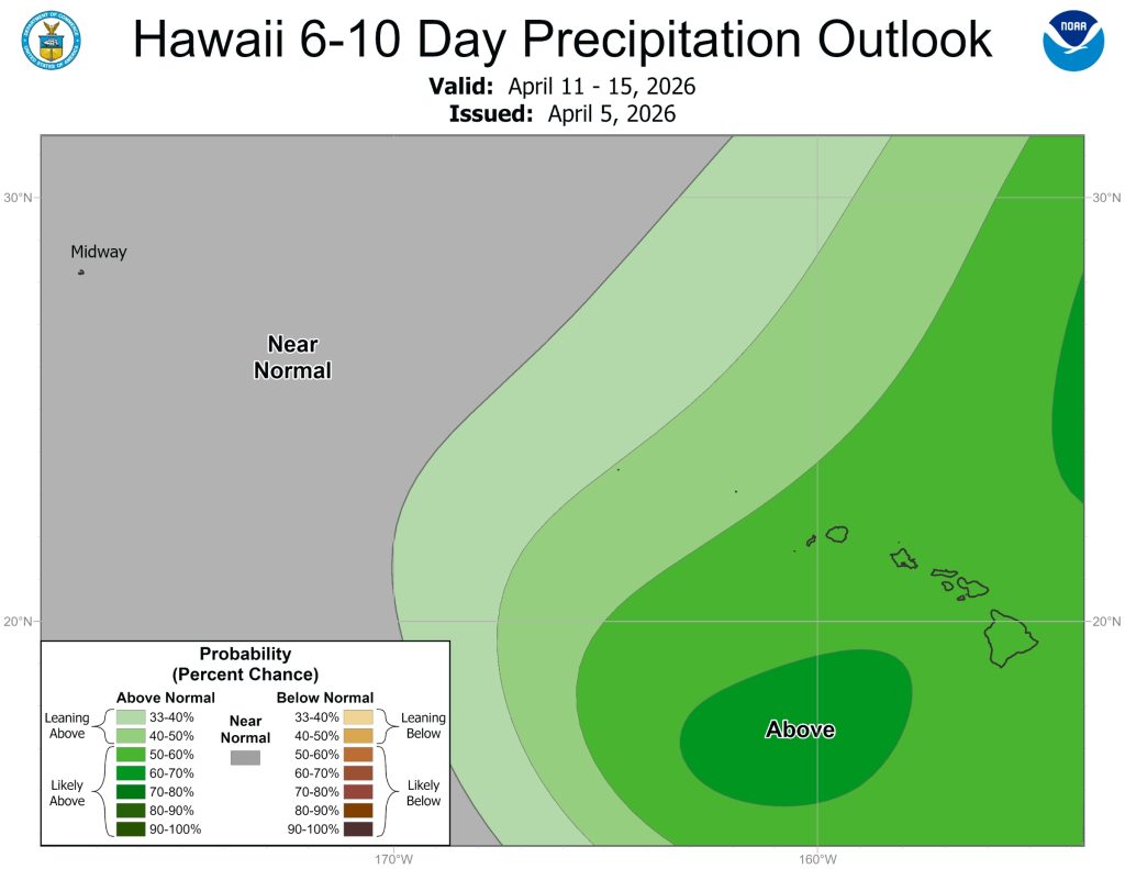
 Courtesy Graphic: National Weather Service Climate Prediction Center
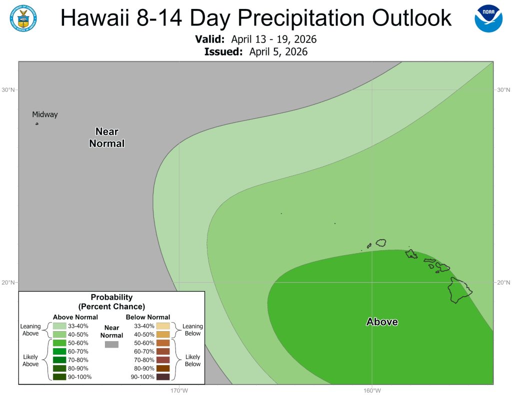
- Courtesy Graphic: National Weather Service Climate Prediction Center

Durgin’s forecast said Sunday, April 5, would remain mostly dry, with vog — or volcanic smog — possible and decreasing easterly winds becoming light from the southeast.
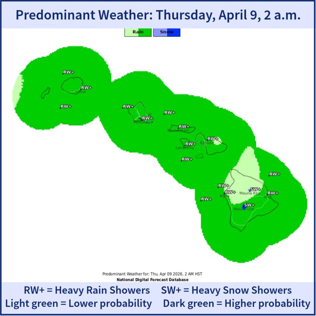
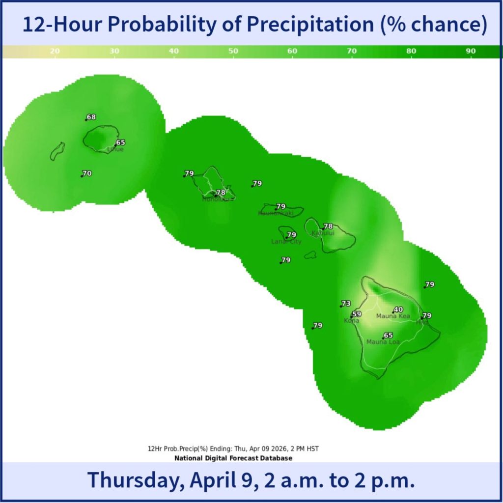
Monday, April 6, also should be mostly dry with vog again a possibility and light southeast winds. Humidity increases Tuesday, April 7, with light to moderate southerly winds and periods of rain — which could be heavy at times — and thunderstorms possible.
Durgin forecasts very humid conditions Wednesday and Thursday, April 8-9, with light to moderate southerly winds and periods of heavy rain.
The humidity remains elevated Friday and Saturday, April 10-11, with moderate to breezy southerly winds in Durgin’s forecast, along with frequent heavy rainfall and strong thunderstorms. That brings the possibility of widespread flooding.
“Extent of any potential flooding threat will depend upon how the system evolves and how quickly it moves through the region,” said National Weather Service.
Durgin’s forecast says a mid-level trough passes by the islands Tuesday, with models showing the jet stream nearby, helping create lift. With moisture riding in on the southerly flow closer to the surface, precipitable water values increase, resulting in conditions capable of producing heavy rain and thunderstorms.
Some decrease in rain and thunderstorm is likely as the trough to the north of the state moves away, but Durgin says moisture will continue to increase through Wednesday. That equates to possible continued periods of heavy rain.
Precipitable moisture — the total depth of liquid water that would result if all water vapor in the atmosphere from ground up condensed and fell as rain — again increases Thursday, reaching about 2 inches, and hovers at about that level through the weekend and possibly longer.
Values of 2 inches and more often indicate a high-moisture air mass capable of producing heavy rain and flooding, commonly found in tropical systems.
Durgin says it will be enough to support more heavy rainfall even without another trough nearby.
But with deep moisture already in place, along with an upper level trough expected to approach the state with an accompanying surface low and cold front, plus soils likely already being saturated, the risk of flooding becomes even more widespread.
- Courtesy Graphic: Hawai‘i Emergency Management Agency Facebook page
- Courtesy Graphic: Hawai‘i Emergency Management Agency Facebook page

“At this point, it looks like the highest winds will be closer to Kaua‘i and O‘ahu,” said Durgin.
National Weather Service forecasters also already are issuing special weather statements about the possibility of this weather system — and its southerly winds — coinciding with the next episode of lava fountaining at the Kīlauea summit.
People who live downwind of the volcano — or plan to visit the summit area and Hawai‘i Volcanoes National Park — need to stay informed about volcanic activity and weather conditions as they evolve.
They should also be prepared to take precautions if necessary, including disconnecting water catchment systems, and follow all guidance from the National Park Service and Hawai’i County.
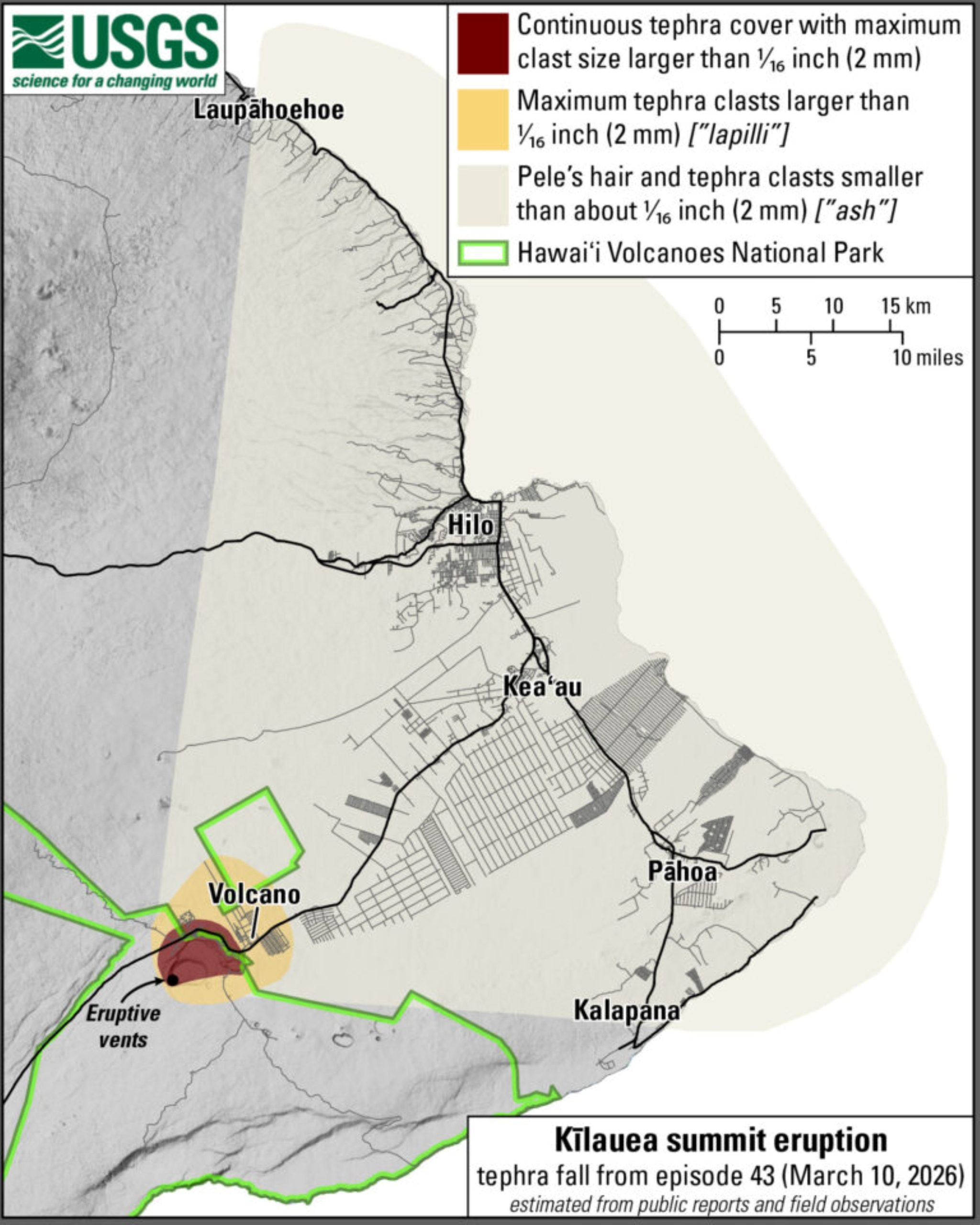
Varying levels of ash, Pele’s hair and other lightweight tephra — a catchall term for erupted volcanic materials — could fall downwind of the summit. Smaller particles, such as ash, can travel even farther from the fountaining site and could impact communities farther away, similar to what happened during Episode 43.
Volcanic fallout could again happen in areas such as Puna, North and South Hilo, Kaʻū and farther if Episode 44 erupts and expected southerly winds blow tephra to the northeast and east.
National Weather Service is issuing daily special weather statements about the potential impact if the next episode of lava fountaining happens during the inclement weather. It will continue to do so as needed.
Hawai‘i Volcanoes National Park also is preparing for the possibility that Episode 44 of the ongoing episodic summit eruption — which began Dec. 23, 2024 — coincides with the expected stormy weather.
Durgin said there are very warm waters to the southwest of the islands, which are the source for the abundant tropical moisture Hawai‘i will see during the next week or two.
“Also within this region and farther west, models continue to forecast the formation of an unusually early in the season typhoon,” he said. “Ensemble tracks take it west, toward Japan.”
Durgin finds that interesting because there are also warm waters to the southeast of the state, which he says could lead to a more active hurricane season this summer and fall.
National Weather Service forecasters said people should prepare for the same type of impacts the state saw from the two back-to-back kona lows last month.
However, because the potential storm was still quite far out at the time the weather agency issued its “heads-up,” specific details such as which islands could be most affected, exact timing, rainfall amounts and more were not yet available.
That should change by the beginning of this work week.
“The National Weather Service forecast office in Honolulu will begin issuing full briefings for this event … on Monday, April 6, as details become more clear,” said the weather agency.
Stay updated about the latest weather advisories, watches and warnings as well as forecast information at the National Weather Service Honolulu Forecast Office website.
You can also find the best local Big Island forecast information and stories in the Weather section at Big Island Now.
Sponsored Content


