

UPDATE: Flood advisory extended through late this afternoon for southeast Big Island
Update at 1:50 p.m. Sunday, Jan. 4, 2026: The flood advisory was extended until 4:45 p.m. today (Jan. 4) for the Ka`u, Puna, and South Hilo districts of the Big Island through this evening.
National Weather Service radar indicated as of 1:26 p.m. heavy rain continuing to move into and over southeast portions of the Big Island. Rain was generally falling at a rate of 1 to 2 inches per hour, with the heaviest rainfall occurring between Hawaiʻi Volcanoes National Park through Pāhoa, including portions of Pāhoa-Kalapana Road and Highway 11.
Flooding is expected in Volcano, Glenwood, Mountain View, Wood Valley, Hawaiian Acres, Pāhala, Orchidland Estates, Hilo, Keaʻau, Pāhoa, Punaluʻu Black Sand Beach, Papaʻikou, Nā‘ālehu, and Fern Forest.
Update at 10:57 a.m. Sunday, Jan. 4, 2026: The National Weather Service forecast office in Honolulu has extended the flood advisory in effect for southeast portions of the Big Island until 1:45 p.m. today, as excessive rainfall continues to cause flooding.
Radar indicated at 10:30 a.m. that heavy rain — still generally falling at a rate of 1 to 2 inches per hour, with the heaviest rates of up to 3 inches an hour between Hawaiʻi Volcanoes National Park and Pāhoa, including portions of Pāhoa-Kalapana Road and Highway 11 — continued to move over parts of the Puna and Kaʻū coasts.
Some locations that will continue to experience flooding include Hilo, Hawaiʻi Volcanoes National Park, Volcano, Glenwood, Mountain View, Wood Valley, Hawaiian Acres, Pāhala, Orchidlands Estates, Keaʻau, Pāhoa, Punaluʻu Black Sand Beach, Kawa Flats, Pāpaʻikou, Nāʻālehu and Fern Forest.
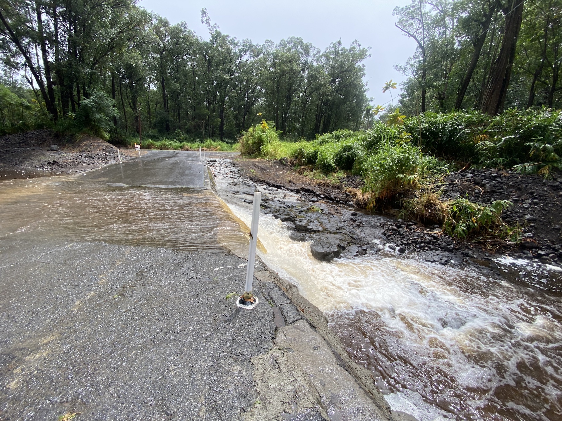
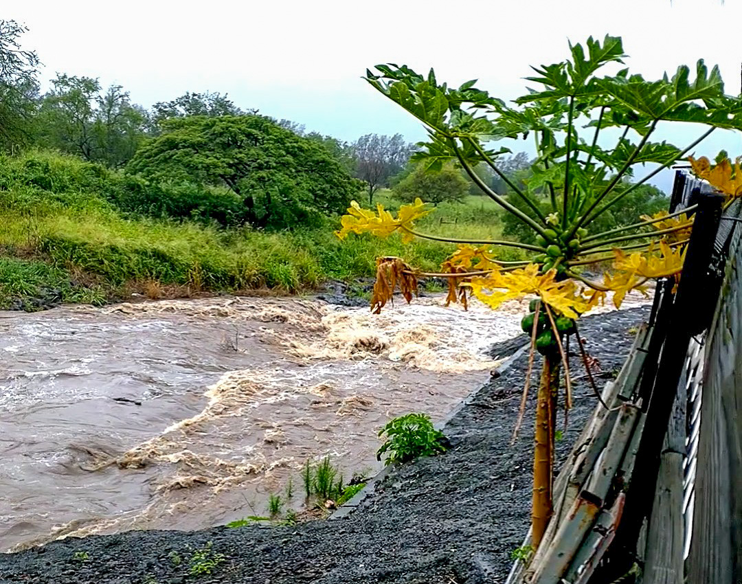
Flooding on roads and in poor drainage areas as well as streams can be expected. Some low-water crossings also could become impassable.
Original story published at 8:10 a.m. Sunday, Jan. 4, 2026: National Weather Service forecasters in Honolulu issued a flood advisory for southeast portions of the Big Island until 10:45 a.m. today (Jan. 4) as excessive rainfall could produce flooding as heavy rain moves over the Puna and Kaʻū districts.
National Weather Service radar indicated at 7:45 a.m. heavy rain falling at a rate of 1 to 2 inches an hour — with isolated heavier rates of up to 3 inches an hour, specifically between Pāhala and Pāhoa, including portions of Pāhoa-Kalapana Road and Highway 11 — was moving over portions of the Puna and Kaʻū coasts.
Some locations that will experience flooding include Hilo, Hawaiʻi Volcanoes National Park, Volcano, Glenwood, Mountain View, Wood Valley, Hawaiian Acres, Pāhala, Orchidlands Estates, Keaʻau, Pāhoa, Punaluʻu Black Sand Beach, Kawa Flats, Pāpaʻikou, Nāʻālehu and Fern Forest.
Flooding on roads and in poor drainage areas as well as streams is expected. Some low-water crossings could also become impassable.
The public is advised to stay away from streams, drainage ditches and low-lying areas prone to flooding.
A flood watch also remains in effect for the entire state through Monday afternoon.
Sponsored Content


