East Hawaiʻi Island districts welcome wet season after abnormally drier dry season
This year’s wet season is a welcome relief after a drier than usual dry season for East Hawaiʻi.

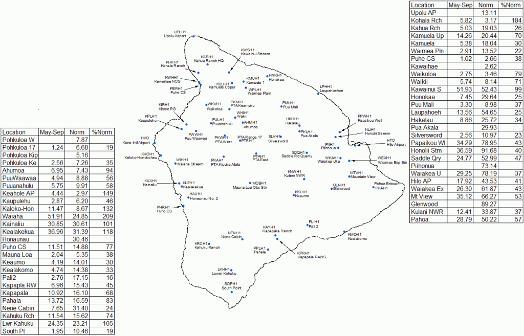
According to the National Weather Service in Honolulu, the rainfall during the dry season, which runs from May through September, was mostly below average on the Big Island, except for the Kona district, which reached its typical summer rainfall maximum.
In September, most of the island was below average in rainfall except for the leeward coast and slopes of the Kohala and Kona districts.
The Hāmākua, Hilo, and Puna districts in East Hawaiʻi continued to be the driest on the island, with the Kūlani rain gauge in Mountain View showing the driest September in its 14-year period of record.
The highest monthly total for September came from the rain gauge at Waiaha Stream on the slopes of the Kona district with 9.41 inches (175% of average). This site also recorded the highest daily total on the island of 3.64 inches on Sept. 1, which unseated Mt. Waiʻaleʻale on Kauaʻi as the highest daily total for the state this month.
While less rain was observed on the Big Island, Oʻahu and Maui County, Kauaʻi experienced slightly above-average rainfall through the season.
Overall, the 2025 season ranked as the third driest in the last 30 years, with Hāmākua and Kaʻū facing the most significant increase in drought severity, followed by the windward and leeward coasts of Oʻahu.
With the wet season officially here, the National Oceanic and Atmospheric Administration’s Climate Prediction Center reports a La Niña advisory in effect. These conditions emerged in September and are expected to continue through the January to February 2026 period, with a 55% chance that conditions will transition to the El Niño-Southern Oscillation cycle, where neither El Niño nor La Niña conditions are present.
These neutral conditions are predicted to continue through March.
According to the National Weather Service, rainfall is predicted to be consistent with a cold-season La Niña event, with the climate model consensus supporting enhanced probabilities for above-normal rainfall through early spring 2026, with the greatest probabilities over the northwestern half of the state.
Rainfall amounts and distribution can be influenced by the strength of La Niña. Weaker La Niña events have generally favored above-normal rainfall during winter in Hawaiʻi in recent decades (since the 1980s), with the potential for more weather systems capable of producing widespread significant rainfall.
However, weather experts state that weak La Niña events do not necessarily result in Hawaiʻi’s wettest wet seasons on record.
For more information on the weather patterns from the last year, visit the National Weather Service website.
Sponsored Content
Comments


