

Update: Big Island officially weathers major winter storm

This story was updated at 5:22 a.m. Feb. 1.
It’s official. The Big Island has weathered the storm.
Some showers and rain lingered over the island into late Friday afternoon, but flooding was no longer expected to pose a threat and National Weather Service forecasters in Honolulu canceled the flood watch that was supposed to be in effect through the rest of the day.
The flood watch was the first advisory to be issued in anticipation of a major winter storm that moved through the Hawaiian Islands during the past couple of days.
Hawaiʻi County was the only island in the state left under a flood watch after conditions improved in Maui County enough for it to be canceled there by just after 6 a.m. Friday.
All other weather advisories were previously canceled or allowed to expire as of early Saturday morning after the storm moved away from the state by mid-afternoon.


Even the summits of Mauna Kea and Mauna Loa — which were forecast to possibily get up to 2 feet of snow dumped on them — were seeing some reprieve as the winter storm warning previously in place was canceled Friday afternoon.
There was just one weather-related advisory remaining by about 6 p.m. Friday, a high wind warning for the summits. National Weather Service forecasters in Honolulu canceled it at about 2:30 a.m. Saturday after winds atop the two mountains fell below warning levels.
The center of the unusually strong winter low-pressure system passed just north of the state, drawing up tropical moisture from the south along its way aided by strong southerly and southwesterly winds.
Heavy rains, strong winds and strong to severe thunderstorms, some of which were capable of producing waterspouts, developed along a cold front that moved across the state as it was dragged behind by the low-pressure system, to wreak havoc from Kauaʻi to South Point beginning Thursday morning.
“It’s been a crazy week, especially with the weather,” said Hawaiʻi County Mayor Kimo Alameda of Friday in his weekly update on social media.
Hawaiʻi County Civil Defense said in a 12:28 p.m. update message Friday that because of the improved conditions:
- All 7 emergency shelters that were opened Thursday afternoon closed at noon today.
- County park facilities closed because of the weather and camping would remain closed until Saturday.
- If your commercial or residential property experienced damages related to the storm, report them to Civil Defense on the agency’s website or by calling 808-935-0031.
Several facilities, however, remained closed as of about 3:30 p.m.:
- Māhukona Wharf (North Kohala).
- Hilo Municipal Golf Course.
- Kona Community Aquatic Center.
- Charles “Sparky” Kawamoto Swim Stadium (Hilo).
- NAS Swimming Pool (Hilo).
Panaʻewa Rainforest Zoo and Gardens in Hilo and Kea’au Armory did reopen Friday.

All Hele-On Bus routes previously canceled because of inclement weather also resumed service as of 10:30 a.m. Friday.
Hawaiʻi Department of Education reported 6 public schools in South Kona were closed Friday because of major flooding causing accessibility issues on their campuses:
- Ho‘okena Elementary.
- Hōnaunau Elementary.
- Konawaena Elementary.
- Konawaena Middle.
- Konawaena High.
- Ke Kula ʻO ʻEhunuikaimalino.
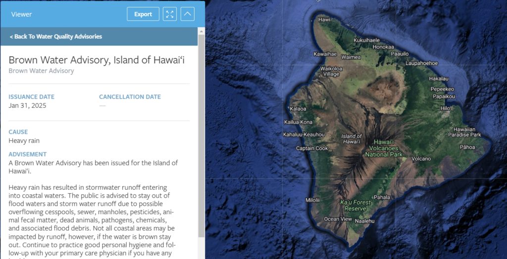
The public is also being advised by state health officials that if the water is brown, turn around.
A brown water advisory was issued Friday by the Hawaiʻi Department of Health Clean Water Branch for the entire island because of stormwater runoff entering coastal waters from heavy rains.
“The public is advised to stay out of flood waters and stormwater runoff due to possible overflowing cesspools, sewer, manholes, pesticides, animal fecal matter, dead animals, pathogens, chemicals and associated flood debris,” said state health officials in their notification.
Not all coastal areas could be impacted, but if the water appears brown or murky, the public is advised to stay out. Also continue to practice good personal hygiene and follow up with your primary care physician if you have any health concerns.
Avoid swimming, wading in or drinking water from any freshwater streams or ponds to prevent the bacterial infection leptospirosis.
Officials recommend staying out of the water for 48 to 72 hours after the rain has stopped and after the beach has received full sunshine.
 Screenshot from Hawaiʻi Department of Health Clean Water Branch website
- Portion of a screenshot of an image from the Hawaiʻi Department of Health Clean Water Branch website.


Hawaiian Electric worked throughout the night Thursday into Friday, reducing the number of power outages its customers on O‘ahu and in Maui and Hawai‘i counties to about 10,800 as of 9 a.m. Friday, down from 39,500 at 8 p.m. Thursday night.
Fewer than 200 customers on the Big Island were still without power as of 4 p.m. Friday, in pockets of Hilo, Honoka‘a, Kohala, Holualoa, Hōnaunau, Kealakehe, Konawaena, Ka‘ū, Pahala, and Nā‘ālehu.
The utility got that number down to fewer than 100 customers in Hilo, Kona and upper and lower Puna by 6 p.m., but said some customers could remain without power overnight.
Crews had restored power to about 3,700 customers since Friday morning and continued to work.
“We appreciate the public’s continued patience as our employees work as quickly and safely as possible to restore all of our customers,” said Jim Alberts, Hawaiian Electric senior vice president and chief operations officer.

About 200 Hawaiian Electric crews and contractors continued inspections and repairs throughout Friday to address the remaining outages, many caused by downed trees and weather-related debris blown into power lines.
Update at 9:57 a.m. Jan. 31: The National Weather Service in Honolulu has issued new speical marine warnings for southeast and windward waters off the Big Island until 10:30 a.m. and windward waters until 11 a.m., with swirling columns of water now a possibility as strong to severe thunderstorms continue moving to the northeast.
Portions of Lower Puna also were being battered by a strong thunderstorm, with wind gusts of up to 40 mph capable of knocking down tree limbs and blowing around unsecured objects.
The storm was expected to impact locations including Pāhoa, Leilani Estates, Isaac Hale Beach Park, Nānāwale Estates, Hawaiian Beaches and Kalapana until about 10:15 a.m.
Radar indicated at 9:25 a.m. severe thunderstorms capable of producing waterspouts were located along a line extending to the southeast along a line off Puna and Kaʻū, moving northeast at 35 knots (about 40 mph). Wind gusts of 34 knots (about 40 mph) or stronger also have been observed.
Additional severe thunderstorms capable of producing waterspouts also were indicated on radar at 9:52 a.m. located along a line extending from near Cape Kumukahi in Lower Puna to about 6 nautical miles southeast of a fish aggregating device, or FAD, buoy. They were moving northeast at 35 knots and also producing wind gusts of 34 knots or stronger.
Waterspouts form suddenly. They can easily overturn boats and create locally hazardous seas. Small craft could be damaged in briefly higher winds and suddenly higher waves.
Locations impacted include Cape Kumukahi in Lower Puna and a fish aggregating device, or FAD, buoy in the waters covered by the warning.
Seafarers and the public should prepare for gusty winds, steep and fast-building seas and blinding downpours. Stay low or go below, and make sure — if you are on a vessel in the affected waters — all of those aboard are wearing life jackets.
If you encounter a waterspout, seek safe harbor immediately.
Original post from 9 a.m. Jan. 31: The National Weather Service in Honolulu has issued a special marine warning for southeast and windward waters of the Big Island until 9:30 a.m. as hazardous weather conditions related to a strong winter weather continue to impact the island and the waters around it.

Radar indicated at 8:33 a.m. strong thunderstorms located along a line extending southeast over waters off the Puna and Kaʻū districts, producing wind gusts of 34 knots (about 40 mph) or stronger, moving east at 20 knots (about 23 mph).
Small craft could be damaged in briefly higher winds and suddenly higher waves.
Locations impacted include will include Cape Kumukahi in Lower Puna and several fish aggregating device, or FAD, buoy areas.
Seafarers and the public should prepare for gusty winds, steep and fast-building seas and blinding downpours. Stay low or go below, and make sure — if you are on a vessel in the affected waters — all of those aboard are wearing life jackets.
A flash flood warning also remains in effect until 11 a.m. for portions of North and South Kohala, North and South Kona, Kaʻū and Puna.
Sponsored Content


