

More than ‘just another raining day’ on the Big Island: Hone starts to make an impact
A relative quiet hung over middle Kaʻūmana early this morning in Hilo town.
The familiar chirps, clicks, coos and songs of the finches, mynas, doves and java sparrows were muted, nearly absent, as just a few of the neighborhood’s avian allies ventured out, compared with the usually vibrant chorus and bustling activity most other days.
There weren’t even any flies fleeting about or gnats annoying you — nary a bug around at all to bug you.
Of course the exception was the regularly rackety rooster, but even he seemed a little off. Chickens. What are you gonna do?

A cacophony of water droplets dribbling, diving from gutters, awnings and overhangs, striking car tops and already soggy yards and driveways, provided percussion for winds rustling palm fronds, branches and other flora, accompanying a hushed feeling — and dim, gray, thick overcast skies — that something was coming.
The Big Island remains under a tropical storm warning as Tropical Storm Hone is now less than 150 miles away from the island and still headed this way.
The center of the storm is expected to pass just to the south of the island tonight and Sunday morning before moving off to the west by early next week.
Rain was falling before forecasters in Honolulu issued their 5 a.m. update for Tropical Storm Hone.
The heavens have continued to produce precipitation since, sometimes heavy, sometimes coming down in sideways curtains and at other times in slow showers.
It’s pretty much been constant in Hilo since about 3:30 p.m. or so. By about 5:30 p.m., it was raining pretty heavily.
Winds steadily increased throughout day.
Electricity in some areas has been flickering and in others had already been off for an extended period.
Hone was 125 miles south-southeast of Hilo and 105 miles southeast of South Point as of 5 p.m. The storm was about 160 miles southeast of Kailua-Kona.
The strong tropical storm had sustained winds of 65 mph, just 9 miles shy of hurricane-force winds, with greater gusts.
Hone continues to steadily move west at 14 mph toward the Big Island.
Tropical-storm-force winds extend outward up to 125 miles from the center.
East-facing shores of the Big Island are experiencing high surf conditions, with large and disorganized surf forecast to rapidly rise to 14 to 18 feet today through this evening.
High winds and flooding rains are forecast to start impacting the island as early as this evening and continue through early Sunday.
Portions of the Big Island have already seen sustained winds around 30 mph. Winds will continue to increase and could become locally damaging by nightfall.

Tropical storm conditions, with sustained winds stronger than 39 mph, with gusts in excess of 60 mph, are expected tonight into early Sunday, especially for areas downslope from higher terrain, over headlands and through passes.
A member of the Hawai‘i Tracker group on Facebook posted shortly after noon that the National Weather Service raised the possible maximum wind gusts for the most windy downslope areas of the island — primarily places such as leeward Kohala, South Kohala and possibly Waimea and the Humu‘ula Saddle — up to 80 mph.
Robert Ballard added there already had been gusts measured at nearly 50 mph near Waimea, Kohala Ranch and Waikōloa as of midday today, and urged his fellow group members to be safe.
A flood watch and high surf warning for east-facing shores remain in effect.
An estimated 6 to 12 inches of additional rainfall, with locally greater amounts, is possible along the Big Island’s windward and southeast-facing slopes, which are already saturated.
Rainfall of 2 to 4 inches has already fallen across windward areas of the island, and as Hone moves closer, bands of heavy showers and thunderstorms are expected to intensify late this afternoon and tonight, bringing a threat of flash flooding.
The greatest potential for flash flooding will be throughout Hāmākua, Hilo, Puna and Kaʻū.
A few lingering thunderstorms and heavy showers could persist over portions of the island into Monday, especially over leeward and upslope areas.
Forecasters still say Hone will modestly strengthen during the next 24 to 36 hours; however, it is no longer expected to reach hurricane status. Instead, it will likely remain just below that threshold at its peak Sunday through Monday.
Hawai‘i Gov. Josh Green issued an emergency proclamation relating to Hone to make sure state resources are available to help as needed in response to the storm’s arrival and any aftermath as well.
The governor is closely monitoring the developing situation.

Hawai‘i County also opened public shelters for anyone who needs them. The following shelters opened as of noon today:
- Kaʻū: Kaʻū Herkes Gym and Nāʻālehu Elementary School cafeteria.
- Puna: Pāhoa High School gym, Kea’au High School library and G Building, and Mountain View Elementary School cafeteria.
- Hilo: Waiākea High School gym.
- Hāmākua: Honoka’a High School and Intermediate School cafeteria.
Anyone who needs to ride out the storm at a public shelter needs to prepare all personal items to stay overnight and be sure to arrive at a shelter no later than 6 p.m.
Questions regarding the public shelters can be directed to Civil Defense at 808-935-0031.
Civil Defense reported, too, that the following roads are closed:
- Waipiʻo Valley Access Road.
- Kohala Mountain Road closed because of a downed tree at the 17 mile marker.
Other road closures could happen without notice.
All east-facing county beach parks also are closed.
Hele On Bus Service canceled routes through the weekend. For a list of canceled bus routes, click here.
The Hawai‘i Department of Transportation also announced that the Hilo International Airport terminal is open; however, there are no further flights out tonight because of the storm.
Travelers should check their flight status before heading to the airport. Do not come to the airport unless you have a confirmed flight.
The state Transportation Department will continue to update the public as Tropical Storm Hone progresses.
“On its current track, Hone will brush past the southern slopes of the Big Island tonight into Sunday morning, bringing the potential for heavy rainfall, damaging winds and large surf,” said the National Weather Service Hawai‘i Area Synopis from 12:08 p.m. today. “Expect strong and gusty easterly winds and periods of heavy showers to continue Sunday into Monday as Hone passes south of the smaller islands.”

The “lesser” species seemed to instinctually know to stay home and hunker down earlier this morning and were doing the same this afternoon.
What continually broke the quiet throughout the day, with their industrial and mechanical dissonance as rubber met wet concrete over and over and them stampeding up and down the hill, sometimes at breakneck speeds, were the dominant species of the planet.
Humans weren’t going to let anything silly like an impending tropical storm get in their way. They had things to do.
Yes. Work is work. That’s a given. But it’s unlikely 100% of everyone on the road today was there because they had to be.
Perhaps a portion of the traffic was people getting last-minute supplies, making final preparations or checking on loved ones ahead of the storm, advice officials have urged since the tropical storm formed just a few days ago.
The National Weather Service and Central Pacific Hurricane Center in one of their last updates about Hone said preparations for the storm’s impacts should have been finished before about noon.
“At this time, again, wanna make sure everybody’s taking care of the things that they need to take care of around their house, going through their preventive checklist, whether it’s putting aside water or clothes or things like that,” said Hawai‘i County Mayor Mitch Roth in a reel posted shortly before 8 p.m. Friday on his official Facebook page.
Roth reported Saturday in a reel posted shortly before 11 a.m., following a briefing with Hawai‘i County Civil Defense, that the island was already seeing a lot of rain and it would definitely see more, probably into Sunday, winds and heavy waves, adding it’s probably not a good time to go in the ocean.
In both reels, the mayor also made sure to direct people to the Civil Defense website to get timely and accurate information about closures, preparedness, hazards, cancellations and more, along with additional resources.
“The storm is on our doorstep and we’re still expecting high winds and heavy rains,” said citizen meteorologist Harry Durgin in his 2 p.m. Tropical Storm Hone update in the Puna Weather group on Facebook.
Durgin is the administrator and creator of the group, which has been active since November 2014.
With the return of convection over the northern part of Hone’s circulation, some last-minute strengthening is possible before the storm makes its closest approach tonight.
“Bands of heavier rain started to come ashore and some periods of gusty winds are causing reports of downed branches, and even a downed tree already,” wrote Durgin. “Expect winds to continue to increase over the next few hours and subsequently expect an increase in power outages.”
Some models at one point even showed Hone’s center passing directly over South Point.
Durgin said rainbands will also increase in intensity, possibly becoming torrential at times through the night and into early Sunday.
He suggested in his first Hone update of the day that with the storm strengthening overnight Friday and turning more toward the Big Island, it substantially increased the risk for a repeat of Hurricane/Tropical Storm Iselle.
It’s been 10 years since Iselle was the first tropical cyclone to make landfall in Hawai‘i since 1992. The storm peaked as a Category 4 hurricane in the Eastern Pacific and weakened to a tropical storm right before striking the Big Island on Aug. 9, 2014.

The storm produced waves of 25 feet, leading to significant run up and causing total storm surge water levels to reach 8 to 10 feet above ground in some places in Puna.
Most of the east- and southeast-facing slopes of the island recorded 6 to 10 inches of rain, with a large area receiving more than 12 inches.
The highest rainfall total of 15.25 inches was recorded by the Kulani National Oceanic and Atmospheric Administration Weather Radio transmitter.
Flooding caused by the rainfall from Iselle also caused damage in the southeast portion of the island.
Strong winds from the tropical storm also toppled a large number of invasive albizia trees, which damaged electrical infrastructure. More than 33,000 electric customers on the island were without power following Iselle initially.
Total monetary loss from the storm ranged from $148 million to $325 million and 11 homes were destroyed while another 50 were damaged.
“A repeat of Iselle?” asked Lauren Broido in a comment on Durgin’s early morning post.
“I certainly hope not!” replied Maren Purves, who also hopes Hone is not a repeat of Category 5 Hurricane Lane in 2018, which drowned parts of the east side of the Big Island in upward of 50 inches of rain as it slowly churned off to the south.
Nobody knows what’s going to happen until it actually does. There’s no way to 100% predict exactly what a tropical cyclone is going to do.
“We are waiting with baited breath!” said Jeffrey Kaye in the comment thread on Durgin’s post.
Unfortunately, some might have waited a little too long to plan for the storm. Especially when it comes to buying certain products that are always in demand during times of emergency.
Moani Maldonado gave members of the Hilo Happenings group on Facebook a heads up at just before 10:30 a.m. Friday that Walmart in town was out of bottled water.
No one was really surprised. It’s nothing new. OMG!
“But do they still have toilet paper?” asked Alex Camblor.
One of the commenters who replied on Maldonado’s post said of course the bottled water is gone, “the news got everyone in a panic and then everyone feels the need to overstock.” She gets the concern, but at the same time, plenty don’t think of others.
Well, why not heed the advice of the National Oceanic and Atmospheric Administration, which offers — and has offered for years — this simple storm prep tip: “Avoid having to rush through potentially life-saving preparations by waiting until it’s too late. Get your disaster supplies while the shelves are still stocked.”
Even as officials warned about the impending impacts of Hone and urged the public to take precautions, some still didn’t want to admit that this could be “that kind of storm.”
Kate Selig, a reporter for The New York Times covering how Big Island residents were preparing for Tropical Storm Hone, asked for comments in several Facebook groups.
“This ain’t the storm you’re looking for honestly, it isn’t gonna make a big impact on the isle in its entirety,” replied Michael Hernandez in one of the threads. “Just be patient; a good one will eventually come along and there will be tons of people wanting to give you a story.”
Andy O’Callaghan said it’s just rain. Come back for a big one. Douglas Salinger alluded that tropical cyclones aren’t really a big deal here until they reach Category 3 hurricane status.
“Just another raining day in Hawai‘i,” commented Frank Enos.
Yes. It’s just another rainy day on the Big Island.
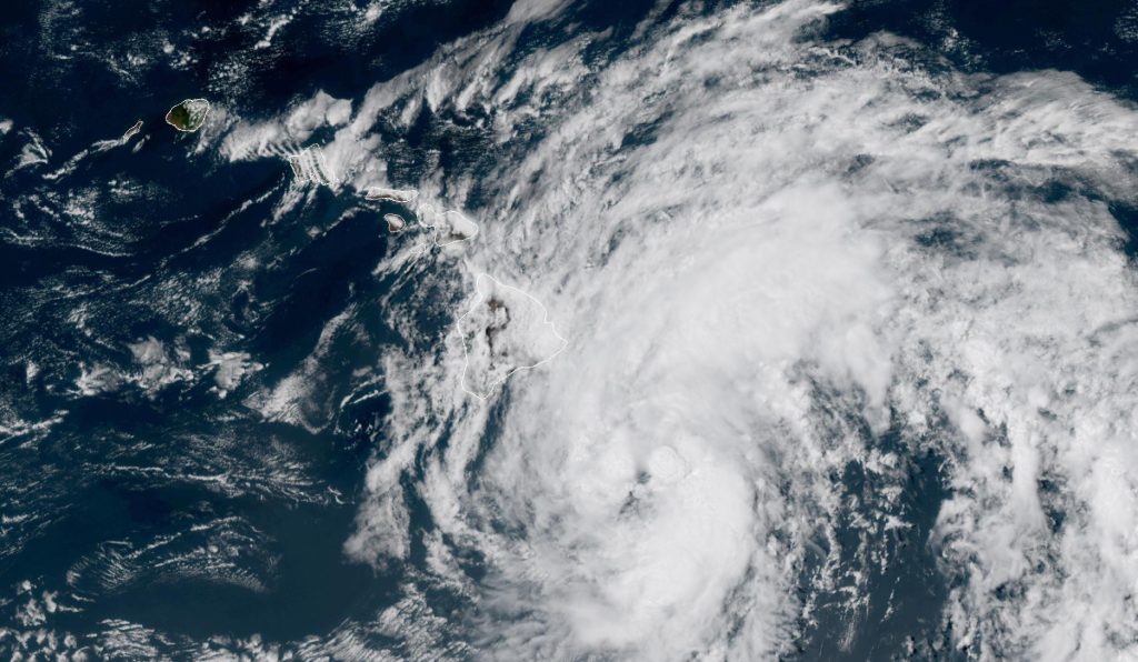
 National Weather Service satellite image from early Saturday afternoon.
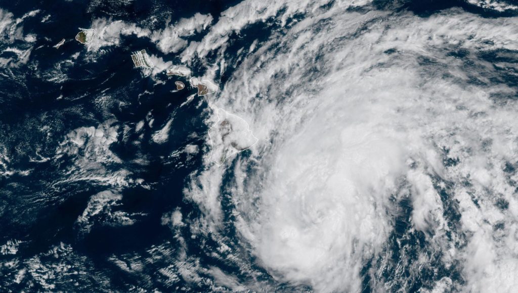
- National Weather Service satellite image from later Saturday morning.
- National Weather Service satellite image from Saturday morning.
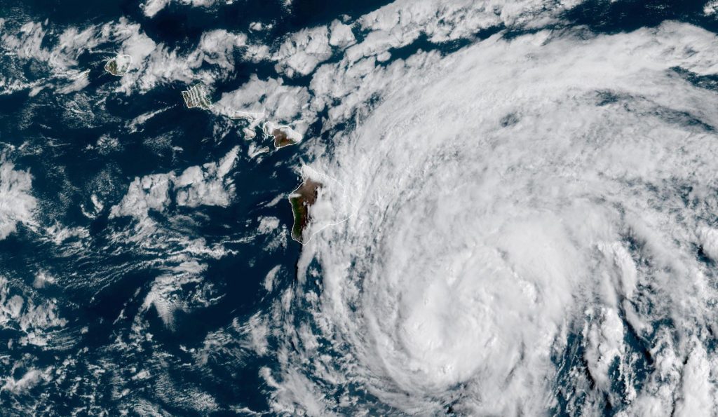
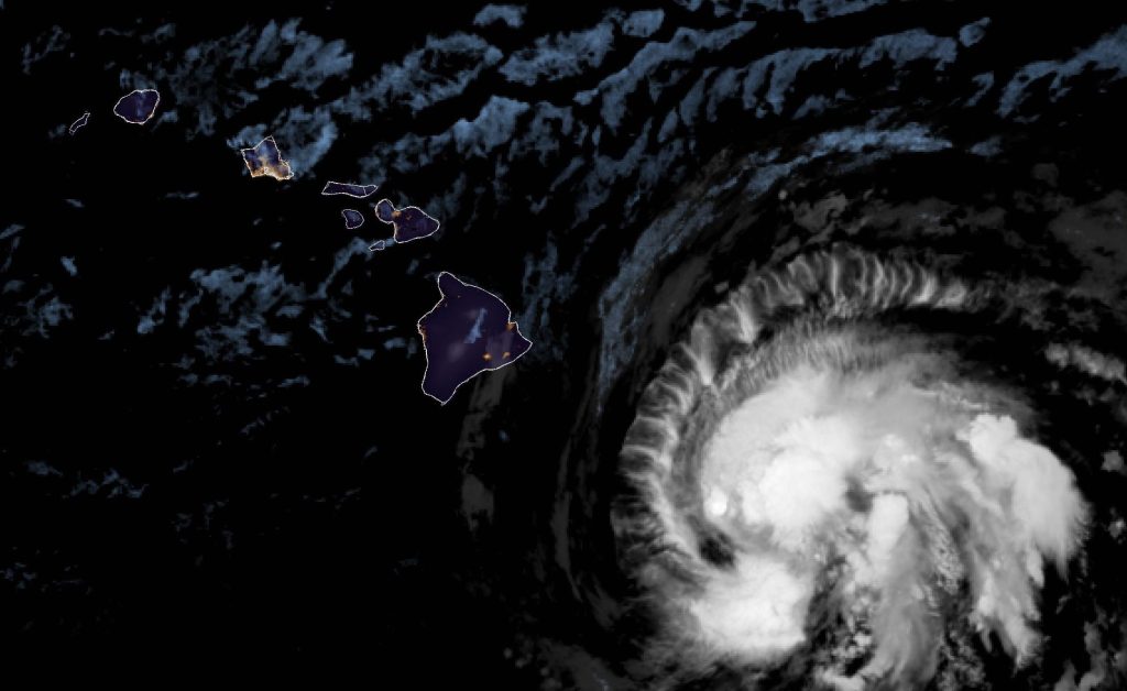
- National Weather Service satellite image from early Saturday morning.


When power lines are arcing in Hawaiian Acres as seen in a video shared on Facebook, winds are gusting to 80 mph and some places have already gotten upward of about 8 inches of rain in a matter of about hours.
When people are worried they can’t get bottled water for their emergency needs because a Big Box store is out of it.
When there are more than 20 power outages around the island before the storm ever really strikes, putting more than 8,500 people in the dark as night is falling — and that was just the most recent update in the Facebook post.
When people are asking friends on social media where they can go if their homes get flooded. Where the county and Red Cross opened shelters to help.
Sure. Nothing to worry about here at all.
By 6 p.m., a low roar could be heard in the distance above the trees. Any other day, it could have been mistaken for a jetliner taking off from Hilo International Airport, but no flights were leaving as Hone came knocking.
It was the wind. And the night was just starting.
Even that ornery rooster had finally gotten the point and found shelter.
“There are hazards out there that could be life-threatening, so take this seriously and don’t take chances,” warned Hawai‘i County Civil Defense Administrator Talmadge Magno in a story by O‘ahu news outlet KHON2.
Sponsored Content


