Light at end of tunnel for Puna’s road woes caused by lava from 2018 Kīlauea eruption

During the 2018 Kīlauea eruption, Tisha Montoya lost 18 structures and much of her farm, known as the Fruit of the Forest, that nestled up to Pohoiki Road in Mālama Estates on the Big Island.
In all the devastation, a quarter acre of the farm with “deep soil and beautiful fruit trees” was spared, she said. But, deep lava made it inaccessible.
Pohoiki Road was among the 32.3 miles of public and private roads that were inundated with lava several feet deep during the three-month long eruption. Today, flowers, trees and grass grow out of cracks of the remnants of the unburied pavement.
Only 3.2 miles of the 13 miles of lost public roads has been restored and reopened: a section on Highway 132 and an 1,100-foot section of Old Government Beach Road from Four Corners. The work was done in November 2019 with funding from the Federal Highways Administration.

Hawaiʻi County has been awarded $82 million by the Federal Emergency Management Agency to restore most of the remaining miles of destroyed public roads, but the work can’t begin before the completion of an Environmental Assessment. A draft of it was finally released last week. Itʻs now in the public comment stage.
The miles of lost roads have cut some people off from their homes and businesses that survived the lava. This includes a handful of properties with homes on the northernmost end of the Vacationland/Kapoho area were spared, but can only be reached on foot. Restoring Highway 137 between Pohoiki Road and Four Corners will provide some access to that general area.
The miles of lost roads also have made traveling around Puna a lot more difficult and time consuming for many residents.
“Not having the roads open adds a lot of drive time, a lot of gas money,” Puna resident Rebecca Corby said. “Before it only took 20 minutes to get from Pohoiki Road to Pāhoa Town. With the roads still down, it takes over an hour to get around the Pāhoa area whether it’s to visit friends, go to the beach or head out of town.”
Jon Olson, Puna resident and one of the founders of the Pāhoa Lava Zone Museum, lost his home of 40 years in Leilani Estates during the eruption. He said the lack of roads creates a dangerous situation because the subdivisions throughout Puna have only one road in and out and there is no connectivity.
Montoya also said it also has caused disconnection of community members from their land and the mana.
With the recovery process frustratingly slow over the past five years, people have taken a lot of different paths to deal with the road problems. Some people have taken a buyout through the County program to sell their property that was spared but unaccessible.

Others have been resilient. Deb and Stan Smith, despite being almost 70, hike over 700 feet of lava to get to their home in Kapoho. They plan trips to town once or twice a week for grocery shopping and various appointments, having to lug whatever they buy those 700 feet. Deb Smith even made the treks with crutches and a cast on her right leg.
Only two months ago, a temporary road was completed to within a quarter mile of Montoya’s farm. But hiking there still is not easy. Fire ants get into her dogs’ eyes. It’s exhausting carrying weed-eaters and chain saws. And, “you get really scratched up,” she said.

Puna business owner and community advocate Amedeo Markoff has read the 149-page draft Environmental Assessment and agrees with the proposed projects that will restore what was lost.
“It’s been a long slog to get to this point,” Markoff said. “I don’t blame anyone for the roads not being restored, but the fact remains they haven’t been restored yet.”

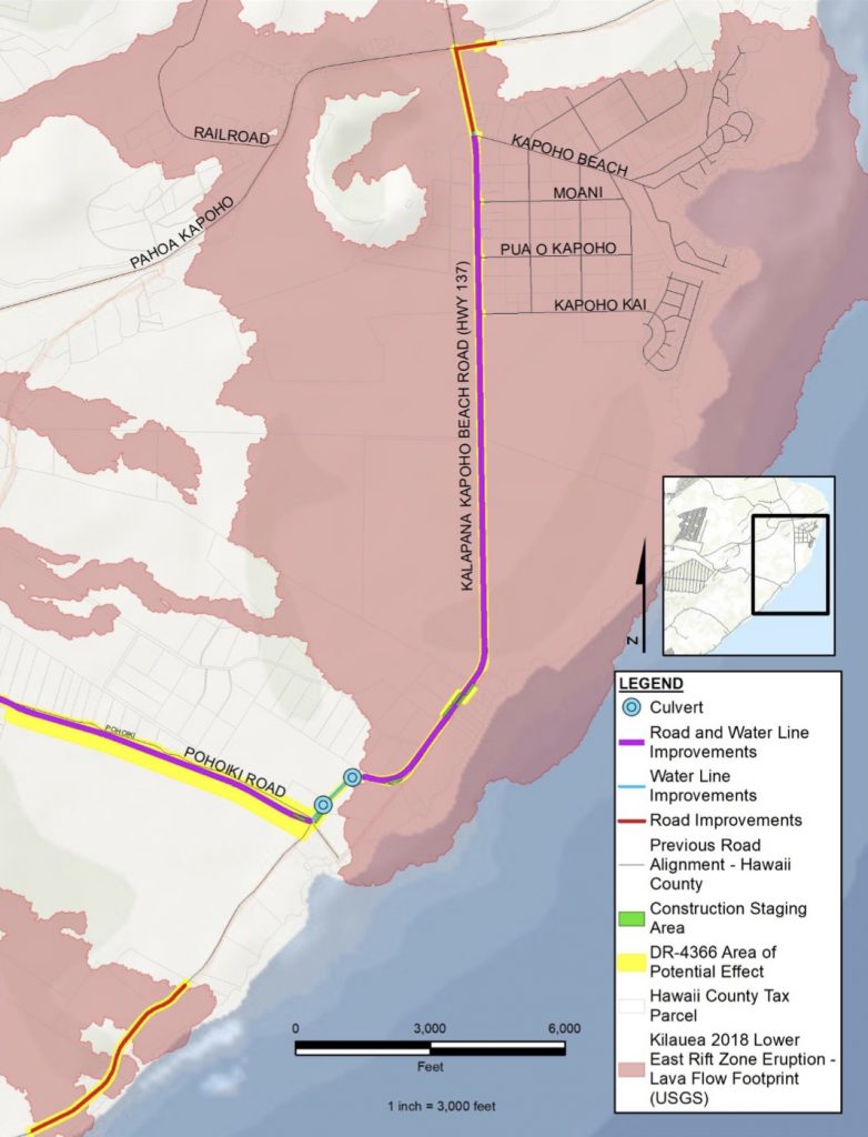
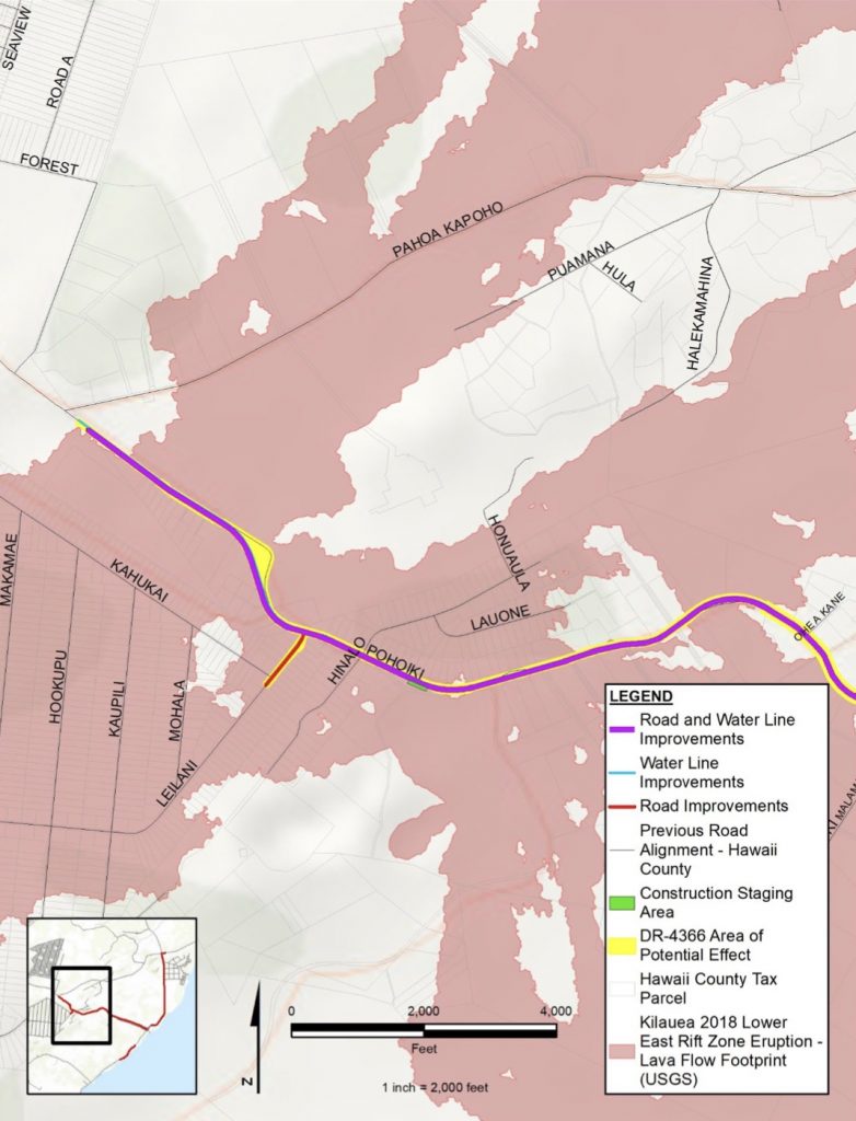
According to the draft Environmental Assessment released Aug. 3, proposed road projects include:
- 4.4 miles of Pohoiki Road at the intersection of Pohoiki Road and Highway 132 to intersection of Pohoiki Road and Highway 137. Proposed improvements include realigning and reconstructing the road and installing a water line.
- 1,000 feet of Leilani Avenue between Kahukai Street and Pohoiki Road. Proposed improvements include reconstruction of road.
- 3.4 miles of Highway 137 — north of Kalapana- Kapoho Beach Road — from Pohoiki Road to the intersection with Highway 132 and Kumukahi-Lighthouse Road. Proposed improvements include realigning and reconstructing the road and installing a water line.
- 60 feet of Kapoho Beach Road along the road from Highway 137. Proposed improvements include realigning and reconstructing the road and installing a water line.
- 25 feet of Moani Street along road from Highway 137. Proposed improvements include reconstructing the road.
- 25 feet of Pua O Kapoho Street along road from Highway 137. Proposed improvements include reconstructing the road.
- 25 feet of Kapoho Kai Drive along road from Highway 137. Proposed improvements include reconstructing the road.
- 892 feet of Kumukahi-Lighthouse Road from intersection of Highways 132 and 137. Proposed improvements include reconstructing the road.
- 4,850 feet of Highway 137 near MacKenzie State Recreation Area, Kalapana-Kapoho Beach Road. Proposed improvements include reconstructing the road.
Public roads Hinalo Street (makai of Pohoiki Road) and Lauone Street to Lanipuna Gardens will not be restored.

Douglas Le, the disaster recovery officer for Hawaiʻi County, said the county is not able to use federal disaster assistance from FEMA for the restoration of private roads. However, the county has worked with nonprofits within the Puna community to provide Kīlauea Recovery grants to help restore access on private roads.
The nonprofit Ono Seeds helped secure a $120,000 Kīlauea Recovery grant to restore Montoya’s property with a temporary road. As of Dec. 31, 2022, volunteers cleared approximately 1,000 trees that were taking over and treating them for fire ants.
These nonprofit organizations also were awarded county grant money to help restore private roads:
- $375,000 was awarded to Mālama O Puna to administer for the Leilani Community Association in Leilani Estates to repair roads damaged by earthquakes during the eruption.
- $175,124 was awarded to Pāhoa Lava Museum to restore private road access to 16 properties isolated by lava in Mālama Homesteads.
- $250,000 was awarded through Men of Pa‘a to support the design, permitting and planning for the restoration of the Vacationland Hawaii Community Association’s private road network.
Click here for the full list of grant money awarded to the nonprofits has been for so far.
One of the private roads is Leilani Avenue, which used to connect the residents of the nearly 60-year-old Leilani Estates with the rustic coast, popular Isaac Hale Park and the important ocean access of the Pohoiki boat ramp.

Now, Leilani Avenue comes to an abrupt end with a guardrail across the pavement and a sign that says “restricted area.” The back third of the subdivision is inaccessible and there are no detours available.
Once the roadwork begins, it will not be easy to build over lava.
“In many areas, there can be nearly 100-foot-thick areas of new lava over old roadways,” Le said. “Since it’s impossible and impractical to merely bulldoze and jackhammer down to the original roads, roadways must be placed on top of lava flows.”
Le said a single cubic yard of lava can weigh between 1,500 to 6,000 pounds, adding county workers will be moving a significant amount of lava to create these roadways.
“It’s a herculean feat in the amount of muscle involved, let alone the extensive amounts of engineering that must happen to complete this project,” Le said.
The surface of a flow can vary wildly by dozens of feet in a just a small area, Le said, explaining these places must be leveled and stabilized using jackhammers, excavators, dump trucks, compactors and motor graders to create a new and stable roadway ready for paving.
After the eruption inundated portions of Highway 137, improvements were made to the county-owned Kamaili Road, also known as Opihikao Road, to provide access to the Pohoiki area. The improvements to the road also provided an alternate route to the Mackenzie State Recreation Area.
Much like building a house, Le said a lot of paperwork, design, permits, planning, alignments and engineering must be done before a single rock is moved.
“We know people are frustrated because they can’t directly see the work we’ve been doing the past few years,” Le said. “But once we’re able to start the construction phase, we’re confident people will see the fruits of all our efforts.”
Editor’s note: This story is the third in a series about recovery efforts from the 2018 Kīlauea Eruption. Tomorrow, we will have a Business Monday story about the Zen Garden, which opened in hard-hit Leilani Estates to help the community heal. And next week, we will explore restoration efforts to the parks and ocean access in the Puna area as well as the restoration of Pohoiki Boat Ramp. Hawai‘i County posts regular updates about their recovery efforts at recovery.hawaiicounty.gov.
Other related stories to the 2018 Kīlauea eruption:
- 5 Pāhoa residents reflect about 2018 Kīlauea lava flow, its impact — and life now
- Recovery frustratingly slow from 2018 Kīlauea eruption, but continues five years later
- 5 years ago on Big Island: ‘Eruption in Leilani, no joke. Lava is coming out right now.’
- 5 years after Kīlauea eruption created new beach, Pohoiki boat ramp remains landlocked
- 2018 Kīlauea eruption destroyed Hawaiian Volcano Observatory’s home; now its getting a new one in Hilo
Sponsored Content
Comments


_1770333123096.webp)


