

What are Kona Lows and why can they be devastating to Hawaiʻi?
Much of East Hawai‘i is used to rain. Hilo, after all, is the rainiest city in the United States, averaging nearly 130 inches per year. That puts the 43 inches of rain that falls on Portland, Ore., in a year to shame, and Seattle’s measly 38 inches is nothing.
However, there are times when severe weather dumps too much rain at once. During the winter — which overlaps with Hawai‘i’s wet season from October through April — a Kona Low can be devastating.
The state is under a flood watch until Saturday evening because of such a storm now moving over the islands that could bring up to 20 inches of rainfall to the southeast and eastern portions of the Big Island during the next several days.
Hawai‘i County Mayor Mitch Roth signed an emergency proclamation Thursday ahead of the expected heavy rainfall to guarantee every resource necessary is available to ensure the community’s safety in the event of severe impacts from the storm.

Hawai‘i’s weather is usually dominated by trade winds. The northeasterly winds are the reason the west side of the state is normally sunny and dry while the east side stays more wet. Trade winds also help keep vog, the volcanic fog caused by emissions from Kīlauea volcano, away from East Hawai‘i.
A Kona Low flips the wind around.
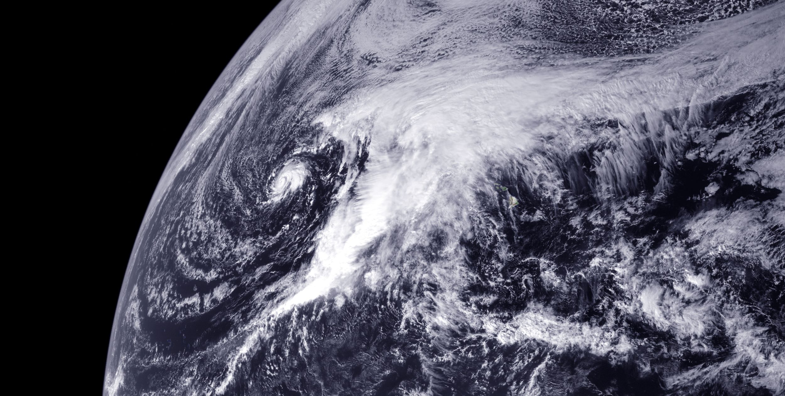
In Hawaiian, “kona” means leeward, or dry side of an island, most often the west side. It is also a name for a southwest or south wind. A Kona Low is a subtropical cyclone that forms northwest of the state, outside the band of warm waters that fuel tropical storms. The counter-clockwise flow around a Kona Low storm system west of the islands results in southwesterly winds.
These storms, unlike their hurricane and tropical storm cousins, form around a cold center and originate from a deep kink in the jet stream, strong winds high in the atmosphere that steer weather systems and pinch off after sinking south. That leaves behind a low-pressure system that can linger for days.
Kona Lows draw abundant moisture from the warm waters around Hawai‘i which then can interact with the land features, or topography, of the islands to produce heavy rains, high winds, large surf, thunderstorms and even hail.
The cold air associated with these storm systems also can cause blizzard conditions at the summits of Hawai‘i’s tallest volcanoes, including Maunakea and Mauna Loa on the Big Island.
“Kona lows are most common during the late fall, winter and spring and are associated with a southward plunge of cold air over the central Pacific Ocean,” according to AccuWeather meteorologist Maggie Samuhel.
On average, Hawai‘i experiences two or three Kona Lows annually, but there have been winters without one of the storms and others where four or five have socked the state.
“Anecdotally, we can have several per year, but it’s just a matter of where they form that determines whether they impact us,” said John Bravender, warning coordination meteorologist with the National Weather Service Honolulu forecast office. “However, we don’t have a Kona Low climatology like we do for tropical cyclones and don’t track how often they occur.”
The state has experienced especially strong and devastating Kona Lows in the past.
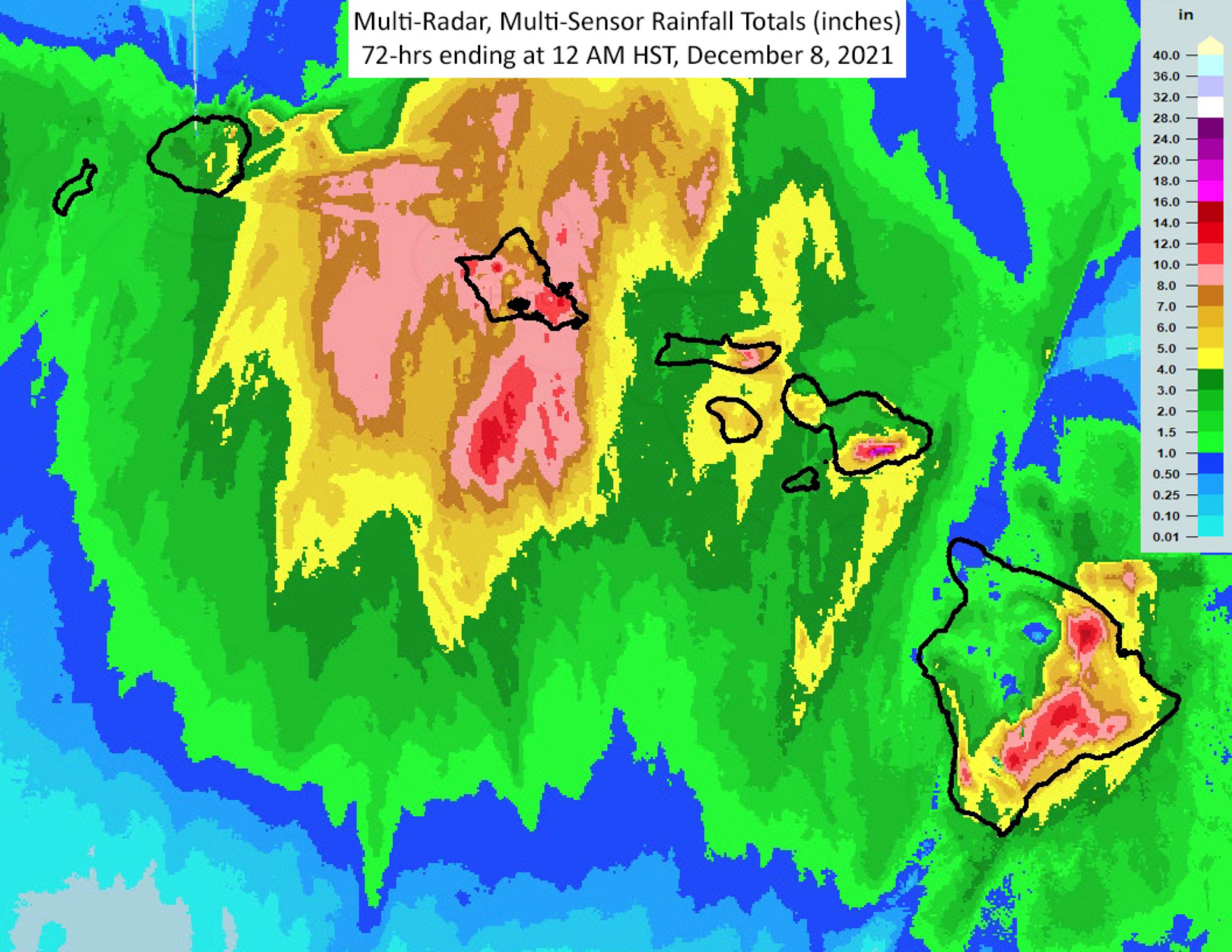
In December 2021, a strong Kona Low developed northwest of Hawai‘i and produced heavy rainfall and strong winds over many areas. The main rain band hit the Big Island first on Dec. 5, then shifted slowly westward across the island chain during the next two days. Rainfall totals were greatest over the southeastern flank of the Big Island, the south and west slopes of Haleakalā on Maui and most of O‘ahu, with the most rain falling on Dec. 6.
Flooding was minimal on the Big Island the first day of the storm, but increased on Dec. 6. Several of the usually dry gulches in Kaʻū flooded and Highway 11 was closed at Kawa Flats for hours.
The impacts from the storm on Maui were so bad that people could apply for a U.S. Small Business Administration federal disaster loan for physical damage sustained from the storm, flooding and landslides. Large flash floods on Dec. 5 filled the normally dry gulches west of Kaupō and closed Piʻilani Highway. Severe flooding in the Maui Meadows subdivision caused damage to homes and washed away several vehicles. Roads in the upcountry Kula area were also closed because of flooding.
Flooding associated with the storm also damaged an electrical substation Dec. 6 on O‘ahu, resulting in a power outage for Downtown Honolulu. Numerous locations on the south side of the island, especially from Pearl City to Kāhala, experienced flooding as well. A section of the H1 freeway through Honolulu was also closed because of waist-deep water near the Vineyard offramp. On the windward side of the island, flooding caused Kamehameha Highway from Waiāhole to Waikāne to be closed.

The strong southerly winds that accompanied the storm, strongest on the Big Island, also caused significant damage in some areas of the state, including multiple reports of downed trees and powerlines and damaged roofs. There were power outages from Volcano to lower Puna because of the wind, and two planes were damaged at Daniel K. Inouye International Airport in Honolulu when an empty storage container was blown into them.
Kaua‘i managed to avoid significant impacts from that storm, but wasn’t so lucky in April 2018.
A record-setting rainstorm associated with a Kona Low inundated some areas of the island with nearly 50 inches of rain during a 24-hour period. That smashed the previous U.S. rainfall record of 42 inches in a day set in 1979 in Texas. The storm caused severe flash flooding and estimated damage of nearly $180 million, damaging or destroying 532 homes. Landslides along Kaua‘i’s north coast left people with no access to their homes for months.
Further back, the most powerful Kona Low to strike the Hawaiian Islands in the past 50 years happened from Jan. 8-11, 1980.
The storm forced the closure of airports throughout the state and rainfall surpassed 20 inches in many locations, particularly on the Big Island and Maui. High surf from the storm caused extensive damage along the Kona Coast. Winds from the storm averaged about 40 to 50 mph, but some areas experienced hurricane-force wind gusts, including a gust of 106 mph in one location on Maui. Damages from that storm were estimated to be between $25 million and $35 million.
And in December 2008, lightning associated with a Kona Low took out the entire O‘ahu power grid, causing a blackout while then President-elect Barack Obama was visiting. In December 2010, a Kona Low transitioned into a tropical cyclone, eventually becoming Tropical Storm Omeka.
Sponsored Content


