


Volcano Watch: From Mauna Loa or Kīlauea? A Geologic Whodunnit
Volcano Watch is a weekly article and activity update written by U.S. Geological Survey Hawaiian Volcano Observatory scientists and affiliates. This week’s article was written by Hawaiian Volcano Observatory postdoctoral researcher Julie Chang.
Mauna Loa and Kīlauea are the two most active volcanoes on the Island of Hawai‘i, and they have overlapping eruption histories. They are located in close proximity, with their summit craters only about about 34 kilometers (21 miles) apart. In fact, part of Kīlauea is built on the southeast flank of Mauna Loa, which is the older of the two volcanoes.
Both volcanoes produce lava flows that can travel many miles from the volcanic vent. Additionally, they produce tephra (material ejected explosively) that can be erupted high into the atmosphere and travel long distances by wind. With this in mind, it can sometimes be difficult to determine, with the unaided eye, which volcano is responsible for a specific lava flow or tephra layer.
Knowing the source of the erupted material, whether from Mauna Loa or Kīlauea, is important for assessing volcanic hazards on the island. Geologists look to past eruptions, both effusive (in the form of lava flows) and explosive (in the form of volcanic ash and other tephra) to understand the frequency of volcanic eruptions. Recurrence intervals can be calculated to determine how often effusive or explosive events occur, which can help forecast when they may occur in the future.
For example, if geologists observe an outcrop with six tephra layers sandwiched between an upper lava flow dated at 800 years ago and a lower lava flow dated at 2,000 years ago — a time period of 1,200 years preserved between the two flows — the minimum recurrence interval would be 200 years (1,200 years divided by six explosive eruptions).
This means that an explosive eruptive event occurred, on average, every 200 years within that 1,200 year time period. If we know that there are six tephra layers, but we don’t know if they erupted from Mauna Loa or Kīlauea, it is difficult to understand how often eruptions occurred from the individual volcanoes.
For example, if only one of the tephra layers were from Mauna Loa, the minimum recurrence interval would be 240 years for Kīlauea and over 1,200 years for Mauna Loa. But if three of the tephra layers were from Mauna Loa, the minimum recurrence interval would be 400 years for Kīlauea and 400 years for Mauna Loa.
So how, then, do geologists determine which volcano produced a certain flow or tephra? Field geologists often use detailed mapping. An explosive eruption, for example, will generally have thicker deposits near the source and thin out away from the source.
Geologists can also use geochemistry to determine if a particular eruptive product is from Mauna Loa or Kīlauea. Studies have shown that the two volcanoes have different geochemical signatures. For example, Mauna Loa lavas generally have higher silica (Si) and lower calcium (Ca), titanium (Ti), and potassium (K) at a given magnesium (Mg) content than Kīlauea lavas.
The two volcanoes and their older predecessors generally have different trace element concentrations and isotope signatures as well, with the geochemistries defining two different families along the island chain. On the Island of Hawaiʻi, Mauna Loa and Hualālai form one family, and Kīlauea, Mauna Kea, and Kohala form another. The chemical differences are thought to originate in the hotspot plume and demonstrate that the magma systems for the two volcanoes are not interconnected.
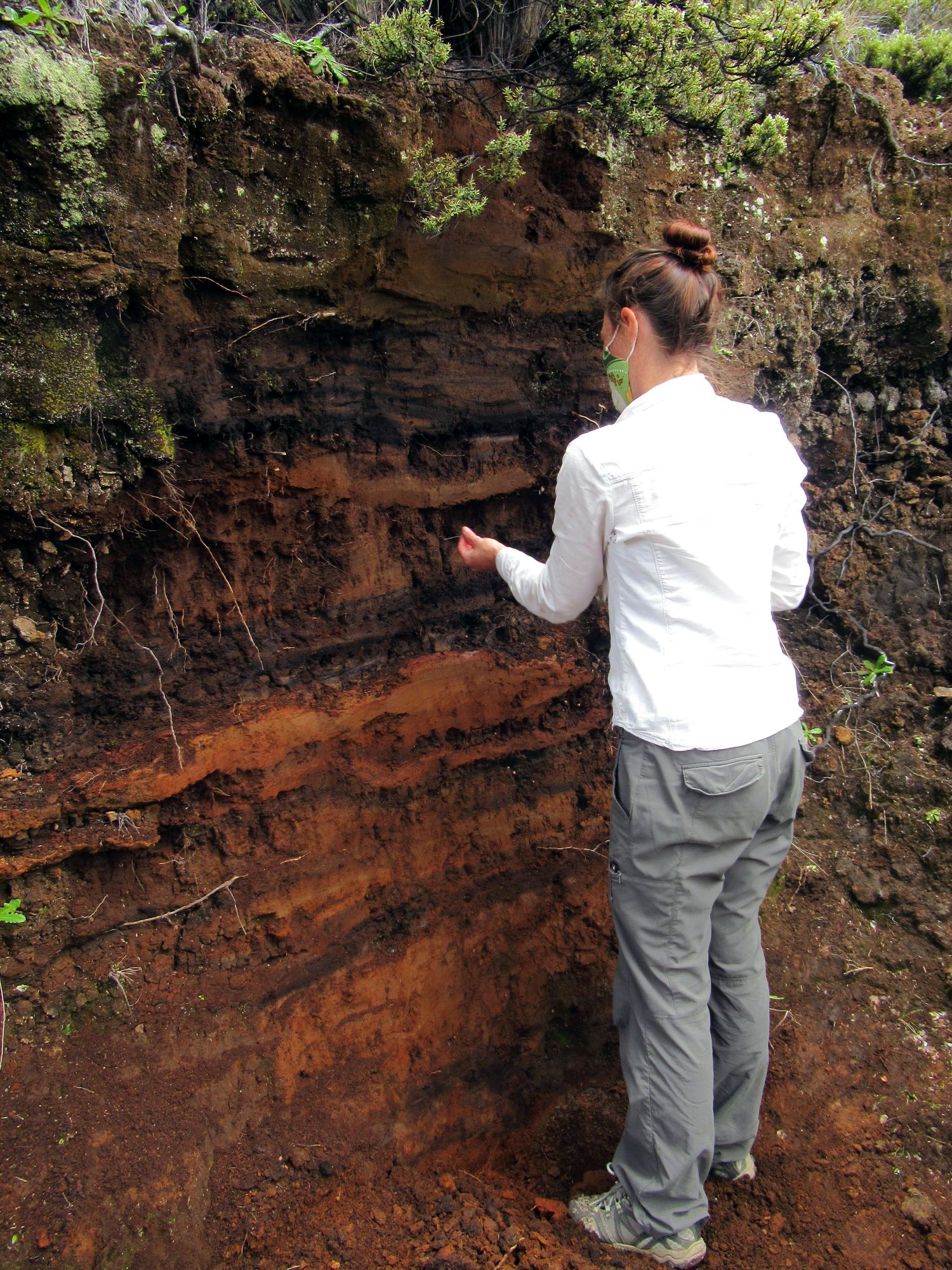
A new study is applying these geochemical differences between Mauna Loa and Kīlauea to understand the volcanic source of individual layers within a two-meter-thick (7 feet) tephra exposure on the southeast flank of Mauna Loa. The exposure is located approximately 19 kilometers (12 miles) south of Moku‘āweoweo, the summit caldera of Mauna Loa, and 35 kilometers (22 miles) southwest of Halemaʻumaʻu, the summit crater of Kīlauea. Due to varying wind directions, either volcano could potentially be the source of the tephra.
Initial geochemistry obtained from fresh glass shards found in the tephra layers suggests that tephra from both Kīlauea and Mauna Loa are present at the field site. Tephras from both the Keanakākoʻi Ash (circa 1500–1820 CE) and the Kulanaokuaiki Tephra (circa 400–1000 CE), which erupted from Kīlauea, appear to be present, as well as at least one tephra layer from Mauna Loa.
The new data will be important for constraining recurrence interval calculations for explosive events on Mauna Loa and Kīlauea and will help the USGS Hawaiian Volcano Observatory provide more robust hazard assessments for the Island of Hawaiʻi.
Volcano Activity Updates
Kīlauea volcano is erupting. Its USGS Volcano Alert level is at WATCH (https://www.usgs.gov/natural-hazards/volcano-hazards/about-alert-levels). Kīlauea updates are issued daily.
Over the past week, lava has continued to erupt from the western vent within Halemaʻumaʻu crater. All lava is confined within Halemaʻumaʻu crater in Hawai‘i Volcanoes National Park. Sulfur dioxide emission rates remain elevated and were last measured at approximately 2,800 tonnes per day (t/d) on April 13, 2022. Seismicity is elevated but stable, with few earthquakes and ongoing volcanic tremor. Summit tiltmeters show several minor deflation and inflation trends over the past week. For more information on the current eruption of Kīlauea, see https://www.usgs.gov/volcanoes/kilauea/recent-eruption.
Mauna Loa is not erupting and remains at Volcano Alert Level ADVISORY. This alert level does not mean that an eruption is imminent or that progression to an eruption from the current level of unrest is certain. Mauna Loa updates are issued weekly.
This past week, about 44 small-magnitude earthquakes were recorded below the summit and upper elevation flanks of Mauna Loa — the majority of these occurred at shallow depths less than 15 kilometers (9 miles) below sea level. Global Positioning System (GPS) measurements show low rates of ground deformation over the past week. Gas concentrations and fumarole temperatures at both the summit and at Sulphur Cone on the Southwest Rift Zone have remained stable over the past week. Webcams show no changes to the landscape. For more information on current monitoring of Mauna Loa, see: https://www.usgs.gov/volcanoes/mauna-loa/monitoring.
One earthquake was reported felt in the Hawaiian Islands during the past week: a M3.7 earthquake 4 km (2 mi) E of Pāhala at 33 km (20 mi) depth on April 7 at 1:37 p.m. HST.
HVO continues to closely monitor Kīlauea’s ongoing eruption and Mauna Loa for any signs of increased activity.
Visit HVO’s website for past Volcano Watch articles, Kīlauea and Mauna Loa updates, volcano photos, maps, recent earthquake info and more. Email questions to askHVO@usgs.gov.
Sponsored Content


