

Volcano Watch: Mapping Kīlauea’s Gas Emissions
Volcano Watch is a weekly article and activity update written by U.S. Geological Survey Hawaiian Volcano Observatory scientists and affiliates.
Large quantities of volcanic gases, such as carbon dioxide (CO2), sulfur dioxide (SO2), and hydrogen sulfide (H2S), are released into the atmosphere during volcanic eruptions. But even between eruptions, smaller amounts of the same gases continue to escape and can provide important clues about the current state of the volcano and the underlying magma. But to measure them, you first must identify where gas is coming from.
Surveys of the gas emissions from the Kīlauea caldera have been done in the past but never of the entire caldera at one time. And none had been done after the 2018 eruption and collapse events—at least not until this year.
Over the summer of 2021, USGS Hawaiian Volcano Observatory (HVO) scientists conducted a detailed gas survey of the caldera floor and rim in order to understand the distribution of current emissions. The results will be compared to previous surveys; if differences are detected, they may indicate that the plumbing system of Kīlauea’s summit has changed because of the 2018 collapses.
Measurements of volcanic gases can be done using a MultiGAS instrument, which pumps in air and then records the concentrations of CO2, SO2, and H2S, plus water vapor, in parts per million (ppm).
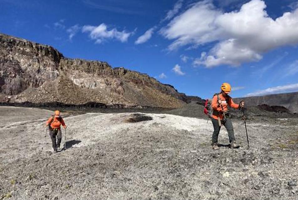
These MultiGAS instruments can be permanently stationed at an area of interest, strapped to a backpack frame, or mounted on a UAS (Unoccupied Aircraft Systems), depending on the location and type of data needed.
For the gas mapping that occurred in the Kīlauea caldera this summer, two MultiGAS instruments were mounted on backpack frames and HVO scientists walked transects in and around the caldera while continuously collecting data. These lines were spaced 25 to 50 meters (75-150 feet) apart and covered areas of the caldera rim, the caldera floor, and the down-dropped block that collapsed during the 2018 eruption.
Even though the survey covered the whole caldera floor, there were also clues that hinted where the best spot to focus on would be. Often gas emissions are concentrated along cracks or holes in the ground which provide the gas an easy path to the surface. Visible plumes can be seen in various parts of the caldera floor and at the Haʻakulamanu (Sulphur Banks) and Steam Vents areas in Hawaiʻi Volcanoes National Park. Visible plumes of gas like this are often good indicators of where the gas concentrations may be elevated.
As gases rise towards the surface from the magma below, they interact with and alter the rocks in the area, resulting in color changes. Looking for this altered rock is another way to identify areas that may have elevated gas emissions.
The scientists also collected gas samples from areas that had elevated concentrations of CO2 for later laboratory analyses. A large, plastic syringe was used to collect the sample which was then transferred to a foil bag designed for holding gas. The majority of the samples were collected on the down-dropped block, as that area showed the highest concentrations of CO2.
Chemical analyses of the different forms (isotopes) of carbon in the CO2 from these samples can provide information about where the magma that is releasing these gases is located, and whether it is new, deep magma that has never degassed before, or older magma that had already been stored for some time in Kīlauea’s plumbing system.
While the caldera floor mapping is now complete, the walls and floor of Halemaʻumaʻu crater have not yet been mapped and are the site of many visible gas vents. These areas are impossible to traverse by foot, so the next step is to use a UAS-mounted MultiGAS to measure gases there, with permission of the National Park Service.
HVO scientists will produce a new map of gas emissions in Kīlauea caldera using the data collected this summer. The map will be key to determining if gas pathways from deep magma to the surface were changed by the collapses in 2018. An updated understanding of gas emission locations across the caldera is essential for HVO’s ongoing gas monitoring. This refined gas emission map will also provide a critical benchmark of gas sources and concentrations that can be monitored for anomalous behavior. The ability to detect changes could also potentially allow HVO to better prepare for eruptions in the future.
Volcano Activity Updates
Kīlauea is not erupting. Its USGS Volcano Alert level is at ADVISORY (https://www.usgs.gov/natural-hazards/volcano-hazards/about-alert-levels). Kīlauea updates are issued weekly.
Kīlauea volcano is not erupting. Following the recent intrusion of magma beneath the surface in the area south of Kīlauea caldera, which slowed substantially on August 30, earthquake rates and ground deformation in this area have remained near pre-intrusion levels. Other monitoring data streams, including sulfur dioxide emission rates and webcam views, show no significant changes. For more information on current monitoring of Kīlauea, see https://www.usgs.gov/volcanoes/kilauea/monitoring.
Mauna Loa is not erupting and remains at Volcano Alert Level ADVISORY. This alert level does not mean that an eruption is imminent or that progression to an eruption from the current level of unrest is certain. Mauna Loa updates are issued weekly.
This past week, about 60 small-magnitude earthquakes were recorded below the summit and upper elevation flanks of Mauna Loa. Global Positioning System (GPS) measurements show no major deformation over the past week. Gas concentrations and fumarole temperatures at both the summit and at Sulphur Cone on the Southwest Rift Zone remain stable. Webcams show no changes to the landscape. For more information on current monitoring of Mauna Loa, see: https://www.usgs.gov/volcanoes/mauna-loa/monitoring.
There were 3 events with 3 or more felt reports in the Hawaiian Islands during the past week: a M3.5 earthquake 13 km (8 mi) E of Pāhala at 29 km (18 mi) depth on Sept. 8 at 6:34 p.m. HST, a M3.6 earthquake 53 km (32 mi) SE of Nāʻālehu at 6 km (4 mi) depth on Sept. 7 at 12:36 p.m. HST, and a M3.4 earthquake 3 km (1 mi) SSE of Pāhala at 34 km (21 mi) depth on Sept. 7 at 2:27 a.m. HST.
HVO continues to closely monitor both Kīlauea and Mauna Loa for any signs of increased activity.
Visit HVO’s website for past Volcano Watch articles, Kīlauea and Mauna Loa updates, volcano photos, maps, recent earthquake info, and more. Email questions to askHVO@usgs.gov.
Sponsored Content


