

VOLCANO WATCH: Aftershock Sequences Can Last for Centuries
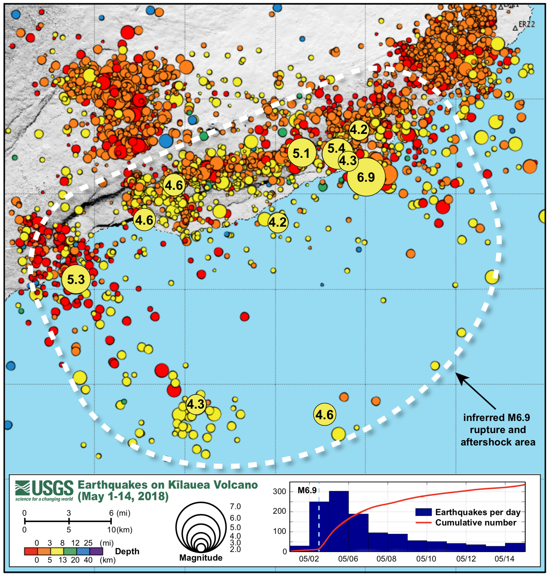
The inferred rupture area (white dashed line) of the May 4, 2018, magnitude-6.9 earthquake, with its foreshocks and first 10 days of aftershocks, spans an area of about 300 square miles. Circle size indicates earthquake magnitude; color indicates earthquake depth. Magnitudes for some of the larger events are labeled. Inset graph shows the aftershock decay rate for May 4 to 15, 2018. PC: USGS
Aftershocks of the 2018 magnitude-6.9 earthquake expected to continue
On May 4, 2018, a powerful magnitude-6.9 earthquake on the south flank of Kīlauea Volcano shook the Island of Hawaiʻi. It was the largest quake in Hawai‘i in 43 years. On Thursday, Oct. 11, 2018, more than five months later, smaller-magnitude earthquakes in the same area are still occurring.
What causes these earthquakes, and how long will they last?
Most earthquakes are caused by patches of rock slipping along a fault plane within the Earth’s crust. The area and the distance of slip relate directly to the energy release (magnitude) of the earthquake.
Slip is not uniform during a major earthquake—some patches move more than others, and some do not move at all. This unevenness in motion within the Earth’s crust puts higher stresses on the patches that did not move than on the ones that did.
As the crust readjusts with time, these higher stresses give way to smaller earthquakes—called “aftershocks”—that occur on adjacent fault patches. The effect can cascade in avalanche-like fashion until the stresses caused by the major earthquake (known as the “mainshock”) even out.
Generally, larger mainshocks produce larger, more numerous, and longer periods of aftershock activity. Aftershock sequences can last from days to centuries.
Not all earthquakes that happen after a major earthquake are smaller. Statistically, there’s about a 5% chance that a larger earthquake will occur within a day after a major earthquake. If that happens, the larger earthquake gets labeled as the “mainshock,” and the previous one is instead labeled a “foreshock.”
During periods of intense seismic activity, there is no way to predict which earthquakes will be foreshocks, the mainshock and aftershocks. These labels are applied retrospectively.
Prior to the 2018 Kīlauea eruption that started in Leilani Estates on May 3, migrating magma pushed through the East Rift Zone of the volcano. This compressed the south flank and caused slip along the island’s basal fault, resulting in thousands of earthquakes near the coast and offshore.
The sequence of larger events started with a magnitude-5.1 earthquake at 10:30 a.m. local time on May 3. A day later, at 11:32 a.m. on May 4, a magnitude-5.4 earthquake then claimed the titled as mainshock. One hour later, at 12:32 p.m., the eventual mainshock of the sequence occurred—the magnitude-6.9 earthquake that rattled the island with enough intensity to knock items off the shelves in Hilo stores. It was also felt statewide and produced a modest tsunami along nearby coastlines.
The first large aftershock occurred later that day—a magnitude-5.3 earthquake at 3:37 p.m. local time. So far, 15 aftershocks of magnitude-4 and higher, along with thousands of smaller events, have occurred in the sequence.
Plotting these earthquakes on a map reveals an area that extends offshore and spans about 300 square miles. We can infer this as the total fault area that ruptured during the sequence.
The statistical relationship between aftershock activity and time was first formulated by the pioneering seismologist Fusakichi Omori in 1894. In what is now known as Omori’s Law, the formula gives an inverse relationship between the probability of aftershocks and time. In other words, the longer the time since the mainshock, the less likely it is that an aftershock will occur. Omori’s formula helps inform aftershock seismic hazard assessment.
In the case of the 2018 magnitude-6.9 earthquake, Omori’s Law forecasts a decreasing frequency of aftershocks continuing in the area over the next year or more, including a small chance of a magnitude-6 earthquake during that time.
Interestingly, Omori had ties to the Hawaiian Volcano Observatory (HVO). In 1912, he supplied Thomas Jaggar, HVO’s founder, with the observatory’s first two seismographs. These instruments were housed in the Whitney Laboratory of Seismology at HVO’s original site near the present-day Volcano House hotel in Hawaiʻi Volcanoes National Park.
Given today’s focus on earthquakes, we take this opportunity to remind you of the upcoming 2018 Great Hawa‘ii ShakeOut on Oct.18, at 10:18 a.m. Join over 70,000 Hawai‘i residents and more than 50 million people worldwide and practice “Drop, Cover, and Hold On”—the appropriate actions to take whenever you feel strong shaking. You can learn more about earthquake safety at https://www.shakeout.org/hawaii/.
Volcano Activity Updates
Kīlauea activity is greatly reduced, with low rates of seismicity, deformation, and gas emissions recorded this past week, and no active lava at the surface of the volcano since Sept. 5, 2018.
Accordingly, on Oct. 5, HVO lowered the Volcano Alert Level for Kīlauea from “WATCH” to “ADVISORY,” and lowered the volcano’s Aviation Color Code from “ORANGE” to “YELLOW.” For definitions of these USGS alert levels and color codes, see online.
Small earthquakes (generally less than magnitude-2.4) continue at Kīlauea’s summit, as do small aftershocks of the May 4th magnitude-6.9 earthquake on the volcano’s south flank. Seismicity remains low along the lower East Rift Zone.
A slight inflationary trend near and east of Puʻu ʻŌʻō over the past few weeks, in addition to a slight deflationary trend at the summit, suggest that some magma may still be moving from the summit magma system into the East Rift Zone.
Sulfur dioxide gas emissions at the summit, Puʻu ʻŌʻō, and lower East Rift Zone remain drastically reduced, with a combined rate of less than 300 tonnes/day.
Hazardous conditions still exist at both the LERZ and summit. Residents in the lower Puna District and Kīlauea summit areas on the Island of Hawaiʻi should stay informed and heed Hawai‘i County Civil Defense closures, warnings and messages (http://www.hawaiicounty.gov/active-alerts).
The USGS Volcano Alert level for Mauna Loa remains at NORMAL.
HVO closely monitors both Kīlauea and Mauna Loa and will report any significant changes on either volcano. HVO now issues Kīlauea updates weekly (on Tuesday) rather than daily. Monthly Mauna Loa updates are posted online. Update frequency will increase if warranted by changing conditions on either volcano.
Four earthquakes with three or more felt reports occurred in Hawai‘i this past week: a magnitude-3.6 quake 15 miles northeast of Hōnaunau-Nāpōʻopoʻo at 4 miles depth on Oct. 8, at 10:54 p.m.; a magnitude-2.8 quake 17 miles west of Pepeʻekeo at 14 miles depth on Oct. 8, at 10:09 a.m.; a magnitude-3.3 quake 9 miles southeast of Volcano at 4 miles depth on Oct. 7, at 8:59 a.m.; and a magnitude-2.5 quake 6 miles east of Waimea at 9 miles depth on Oct. 5, at 3:15 p.m.
Visit HVO’s website for past Volcano Watch articles, Kīlauea and Mauna Loa updates, volcano photos, maps, recent earthquake info, and more. Call 808-967-8862 for weekly Kīlauea updates. Email questions to askHVO@usgs.gov.
Volcano Watch is a weekly article and activity update written by U.S. Geological Survey Hawaiian Volcano Observatory scientists and affiliates. Today’s article is by HVO seismic network manager Brian Shiro.
Sponsored Content


