

Hurricane Norman to Enter Central Pacific This Week
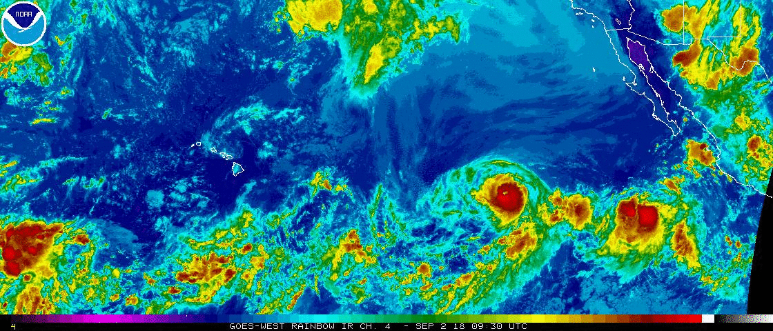
Tropical Depression Miriam fades to the north of Hawai‘i; Hurricane Norman resurges to Category 4; Tropical Storm Olivia forecast to strengthen to hurricane status by Tuesday. Sept. 2, 2018. NOAA
The National Weather Service Hurricane Centers issued updated on three Pacific Storms on Sunday, Sept. 2, 2018.
The NWS Central Pacific Hurricane Center in Honolulu at 5 a.m. reported that Tropical Depression Miriam has weakened to a Tropical Depression far ENE of the Hawaiian Islands, 840 miles NE of Hilo.
Maximum sustained winds are near 35 mph with higher gusts. Additional weakening is forecast, and Miriam is expected to become a post-tropical remnant low later today, followed by dissipation
late Monday.
The NWS National Hurricane Center in Miami, Florida, reported at 5 a.m. that Hurricane Norman has made a remarkable and surprising comeback today.
Satellite images reveal a distinct eye surrounded by a ring of very deep convection, making Norman again a Category 4 hurricane on the Saffir-Simpson Scale, with maximum sustained winds increasing to near 130 mph. Although some of the intensity models are more aggressive in forecasting strengthening, the NHC forecast forecasts a gradual weakening beyond 12 to 24 hours.
Norman is located near latitude 17.6 north, longitude 129.1 west in the East Pacific. Norman is moving toward the WNW at 18 mph. A strong subtropical ridge anchored to the north of Norman will continue to steer the hurricane between the west and WNW at the same speed for the next two to three days.
Some fluctuations in intensity are likely today and Monday, but a gradual weakening trend should begin in the next couple days and a NW turn is expected in four days.
Hurricane-force winds extend outward up to 35 miles from the center and tropical-storm-force winds extend outward up to 115 miles.
The NWS NHC in Miami also issued an advisory on Tropical Storm Olivia at 5 a.m.
TS Olivia remains poorly organized but is forecast to strengthen.
The center of TS Olivia was located near latitude 17.0 north, longitude 112.4 west, 440 miles SSW of the southern tip of Baja, California.
Olivia is moving toward the NE near 7 mph, but a turn to the WNW is expected into Monday, followed by a turn toward the west late Monday or early Tuesday.
Maximum sustained winds remain near 45 mph. Some strengthening is forecast, and Olivia could become a hurricane by Tuesday.
Tropical-storm-force winds extend outward up to 90 miles from the center.
Sponsored Content


