


6 PM: Hector Creates High Surf & Wind Conditions

Hurricane Hector, Aug. 8, 2018, 8:30 a.m. PC: NOAA
Wednesday, Aug. 8, 2018, 6 PM: High Surf & High Wind Conditions
As of 5 p.m., Hurricane Hector was a Category 3 hurricane moving west past South Point. The effects of the passing hurricane have created high surf and high wind conditions along the Ka‘ū coast. Although the Tropical Storm Warning has been cancelled, a High Surf Warning remains in effect.
The following advisories have been issued:
- High Surf Warning for the southeast shores of Ka‘ū and Puna.
- Southwest coast of the island (Ka‘ū to Kona) may experience elevated surf up to 7 feet.
- High wind advisory for the summits of Mauna Loa and Maunakea.
For your additional information:
- Punalu‘u, Whittington and Miloli‘i Beach Parks will be re-assessed for hazards tomorrow.
- The Pāhoa and Pahala early voting stations will reopen tomorrow.
- The Disaster Recovery Center at the Pāhoa Community Center will also reopen tomorrow.
5 PM: Hector Moving Towards West
At 5 p.m. the eye of Hurricane Hector was located by radar near latitude 16.7 North, longitude 156.8 West. Hector is moving toward the west near 16 mph (26 km/h) and this general motion is expected to continue the next couple of days, with a turn toward the northwest expected over the weekend. On the forecast path, the center of Hector will pass several hundred miles south of the main Hawaiian islands through early Thursday.
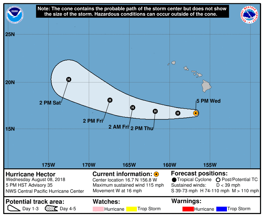
Maximum sustained winds are near 115 mph (185 km/h) with higher gusts. Hector is a category 3 hurricane on the Saffir-Simpson Hurricane Wind Scale. Little change in strength is forecast over the next couple of days.
Hurricane-force winds extend outward up to 35 miles (55 km) from the center and tropical-storm-force winds extend outward up to 90 miles (150 km).
The estimated minimum central pressure is 959 mb (28.32 inches).
Swells generated by Hector will bring large and dangerous surf to portions of the main Hawaiian islands into Thursday. Surf heights near 20 feet were reported on the southeast side of the Big
Island Wednesday afternoon.
Wednesday, Aug. 8, 2018, NOON: Ka‘ū to Kona May Experience 7 Foot Surf
As of 10, a.m., Hurricane Hector was located approximately 220 miles south of Hilo. Hurricane Hector is located at latitude 16.5 N and longitude 155.0 W and moving west at 16 mph. Maximum sustained winds are at 115 mph. If Hector continues on this track, it is forecast to pass south of Hawai‘i Island later today.
Due to the location and strength of Hector, the Central Pacific Hurricane Center has discontinued the Tropical Storm Warning for Hawai‘i Island. All field reports indicate there are no problems occurring due to surf, winds and rain.
Due to the location of Hurricane Hector, the following advisories have been issued:
High Surf Warning remains in effect for the southeast shores of Ka‘ū and Puna.
Southwest coast of the island (Ka‘ū to Kona) may experience elevated surf up to 7 feet.
Police and road crews report that all roads and highways are open.
Punalu‘u, Whittington and Miloli‘i parks will remain closed until all danger has passed.
11:30 AM: Tropical Storm Warning Cancelled
All watches and warnings have been canceled for the Big Island.
Storm winds are clocked at 115 mph moving west at 16 mph.
Hurricane Hector will pass far south enough with minimal impact on the Big Island. Therefore the tropical storm warning for the island is cancelled.
Breezy trade winds will prevail across the state, with strong winds affecting the summits of Mauna Kea and Mauna Loa. A wind advisory is in effect for those areas until midnight.
Surf along east-facing shores continues to build and is expected to peak today. Expect surf heights of 12 to 15 feet mainly for the Puna and Ka‘ū Districts of the Big Island.
High surf combining with seasonably high tides will produce overwash on low-lying coastal areas
and roadways, leading to increased potential for coastal erosion.
Rain bands associated with Hector are moving across the windward and southeast coastal waters of the Big Island. Enhanced rainfall from deep tropical moisture surrounding Hector will affect the Puna, Ka‘ū, North Hilo, and South Hilo Districts of the Big Island through Thursday.
WIND: Little to no impacts are anticipated at this time across the Hawaiian islands, except for the summits of Mauna Kea and Mauna Loa.
FLOODING RAIN: Additional impacts from flooding rain are still a concern across windward Big Island. Remain well-guarded against locally hazardous flood waters having further impacts of limited potential.
Elsewhere across the Hawaiian islands, little to no impact is anticipated.
OTHER COASTAL HAZARDS: Prepare for locally hazardous high surf with coastal impacts along east-facing shores of the Big Island. Higher tides this afternoon will increase the possibility of coastal inundation, due to the combination of high surf and high tides.
Be alert for potential flooding from rising rivers and streams. Remain informed of the latest forecasts and heed any flood watches and warnings.
- For information on appropriate preparations, see ready.gov.
- For information on creating an emergency plan, see getagameplan.org.
- For additional disaster preparedness information, see redcross.org.
10 AM: Category 3 Hector 220 Miles SSE of Hilo
As Hurricane Hector continues to move on a westerly track toward south of the state, Hawai‘i Emergency Management Agency (HI-EMA) continues to work with emergency management and civil defense partners to monitor the storm.
Hector is located about 220 miles south-southeast of Hilo moving west at 15 mph.
A tropical storm warning remained in effect for Hawai‘i County as of 5 a.m.
Large surf is expected today along southeast and east-facing shores of the Big Island and east-facing shores of Maui.
Safety and preparedness recommendations from Hawaii Emergency Management Agency include:
- Do not use candles during a blackout or power outage due to risk of fire.
- Use 9-1-1 only to report life-threatening emergencies.
- Make sure to monitor local broadcasters and/or sign up for local notification systems if you live in a flood prone area.
- Do not attempt to cross fast moving water, especially if you are unsure of the depth.
- Follow the Department of Education online for the latest information on possible school closures. Make sure you know the closure notification procedure if your children attend a private or charter school.
Check with local officials and the Department of Land and Natural Resources (DLNR) if you plan to hike or camp next week. Parks and other trails may be closed depending on the weather forecast. Visit the DLNR website for the latest closure information.
Visitors should download and read the Hawai‘i Tourism Authority’s Travel Safety Brochure.
6 AM: Category 3 Hector 240 Miles SSE of Hilo
- Tropical Storm Warning is in effect for the Island of Hawai‘i. A Tropical Storm Warning means that there is a possibility of strong winds, high surf, and heavy rains occurring anytime within 36-hours. All field reports this morning indicate no problems occurring due to surf, winds and rains.
As of 5 a.m., Category 3 Hurricane Hector was located approximately 240 miles south-southeast of Hilo. Hector is located at latitude 16.4 N and longitude 153.9 W and moving west at 16 mph.
Maximum sustained winds are 125 mph with gusts to 145 mph. If Hector continues on this track, it is forecast to pass south of Hawai‘i Island Island later today.

Enhanced rainfall from deep tropical moisture surrounding Hector will affect the Puna, Ka‘ū, North Hilo and South Hilo Districts as the hurricane passes by south of the state over the next couple of days.
Rain may be locally heavy at times, particularly over east to southeast-facing slopes.
Strong winds are expected to develop today, with the strongest winds over and downwind of the higher terrain on the Big Island.
- High Surf Warning is in effect for the Island of Hawaii (for the southeast shores of Ka‘ū and Puna). Surf along east-facing shores is building and is expected to peak today. Expect surf heights of 12 to 15 feet mainly for the Puna and Ka‘ū Districts. High surf will combine with seasonably high tides producing overwash on low-lying coastal areas and roadways, with potential for coastal erosion impacts as well.

Hector, Aug. 7, 2018, PC NASA Astronaut Ricky Arnold
Due to the location of Hurricane Hector, the following advisories are issued:
- All schools are open.
All roads and highways are open.
The following parks will remain closed until all danger has passed: Punalu‘u, Whittington and Miloli`i.
The Pāhoa and Pahala early voting stations are closed today.
Now is the time to complete all preparations to protect life and property in accordance with your emergency plan. Ensure you are in a safe location before the onset of strong winds or possible flooding.
It is important to remain calm, informed, and focused during an emergency. Be patient and helpful with those you encounter.
Be ready to adapt to possible changes to the forecast.
- For information on appropriate preparations, see ready.gov.
- For information on creating an emergency plan, see getagameplan.org.
- For additional disaster preparedness information, see redcross.org.
Sponsored Content


