

VIDEO UPDATE: Leilani Subdivision Update: 10 Fissures Emerge, 35 Structures Destroyed
Big Island Now Meteorologist Malika Dudley interviews evacuee Isaac Frasier. VC: BIN
Monday, May 7, 2018, 6 a.m.

Fissure map, Monday, May 7, 2018, 6 a.m. MC: https://gis.hawaiicounty.gov
The East Rift Zone eruption in Leilani Subdivision continues. Hawaiian Volcano observatory confirms that active venting of lava and hazardous fumes continue in Leilani Estates Subdivision. Since the onset of this eruption, a total of 10 fissures have emerged, and 35 structures have been destroyed.
The County of Hawai‘i thanks Leilani Estates residents for their cooperation and patience during yesterday’s property retrieval effort.
https://www.facebook.com/ikaika.marzo/videos/1794683663917495/?t=8
VC: Ikaika Marzo, Kalapana Cultural Tours
Due to the eruption, the following are issued:
Conditions permitting, Leilani Estates residents will be allowed to check on their property from 7 a.m. to 6 p.m. each day until further notice. Follow the instructions of the authorities on scene. Be prepared to evacuate at a moment’s notice.
Hawaii Electric Light Company is working to try to keep power online. Treat all downed lines as live. Under no circumstances are you to approach or touch downed lines.
The Department of water Supply is working to establish a temporary bypass waterline to restore water service to the areas of Pohoiki, Vacationland and Kapoho.
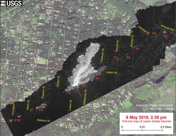
This thermal map shows the ‘a‘ā flow spreading northward (top) from fissure 8 during an overflight of the area on the afternoon of May 6. The black and white area is the extent of the thermal map. Temperature in the thermal image is displayed as gray-scale values, with the brightest pixels indicating the hottest areas (whitish areas show the active lava flow). The gray linear features are the other fissures (numbered in red) that have erupted thus far in the sequence. The thermal map was constructed by stitching many overlapping oblique thermal images collected by a handheld thermal camera during a helicopter overflight of the flow field. The base is a copyrighted color satellite image (used with permission) provided by Digital Globe.
A water truck for public use is located near the Vacationland mailboxes.
No access is allowed at this time for residents of Lanipuna Gardens due to dangerous volcanic gases.
Residents of Leilani need our help. This is not the time for sightseeing. You can help tremendously by staying out of the area.
Department of Education announced Pāhoa High, Intermediate and Elementary schools will be open today. Kua O Ka La, Hawaii Academy of Arts and Sciences, Nawahiokalaniopu’u and Ke Ana La’ahana are closed today.
The Hawai‘i County Police Department and the Prosecutor’s Office have established a policy of zero tolerance towards looting or vandalism. Under Emergency Provisions, any looting or vandalism will be treated as a felony.
Sponsored Content


