

Hawai‘i Volcano Update: Earthquakes & Magma Intrusion Continue
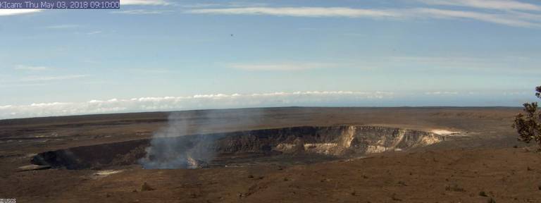
Kīlauea Caldera from HVO Observation Tower, 2018-05-03 9:40:06 a.m. PC: USGS/HVO
The Hawaiian Volcano Observatory reported this morning at 8:48 a.m., Thursday, May 3, 2018, that earthquakes and deformation of the ground related to intrusion of magma into the lower East Rift Zone of Kilauea continue.
Deflationary tilt at the summit of the volcano has been accompanied by a drop in the level of the lava lake in Halema‘uma‘u.
Lower East Rift Zone
Elevated earthquake activity continues in the area of Kīlauea Volcano’s East Rift Zone from Highway 130 eastward towards Kapoho.

The intensity of seismicity has diminished slightly overnight and the trend of eastward migration of earthquake activity appears to have slowed or ceased.
No shallowing of earthquakes has been detected.
HVO’s GPS station in the area continues to show motion related to ground deformation in response to the ongoing intrusion.
Cracks found in a number of roads in Leilani Estates yesterday likely reflect stresses due to ground deformation caused by the ongoing intrusion. No high temperatures or steam or gas were reported associated with any of the observed cracks. Hawai‘i County Department of Public Works reported that the crack across Pohoiki Road stopped opening last night at about 10 p.m.
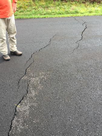
Puna residents reported to HVO geologists the recent appearance of ground cracks on a couple of roads in and around Leilani Estates. PC: USGS/HVO
Although the intensity of seismicity has reduced somewhat, earthquake rates remain elevated and deformation of the ground continues.
Activity could intensify at any time and an outbreak of lava in a new location along the East Rift Zone remains possible.
Based on the location of the most recent seismicity and deformation, the region downrift of Puʻu ʻŌʻō, including the area east of Highway 130, remains the most likely location should an outbreak occur.
Hawaii County Civil Defense and the USGS Hawaiian Volcano Observatory advise residents of the Puna District to remain alert, review individual, family, and business emergency plans, and watch for further information about the status of the volcano. Hawaii County Civil Defense messages may be found online.
Summit Observations: Deflationary tilt at the summit accelerated midday yesterday, May 2, and is continuing this morning. In concert, the summit lava lake dropped over 100 feet. Tremor amplitude is fluctuating with lava lake spattering. Elevated summit sulfur dioxide emission rates persist. Gas emissions remain elevated. Click here for current webcam views.
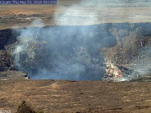
Halemaʻumaʻu Overlook vent from HVO Observation Tower, 2018-05-03 9:44:05 a.m. PC: USGS/HVO
Puʻu ʻŌʻō Observations: Seismicity remains elevated at Puʻu ʻŌʻō but tiltmeters near the cone show no significant deformation overnight. HVO field crews will visit the area today to investigate the impacts of Monday’s collapse and assess the condition of HVO monitoring equipment. Watch the HVO website for photos posted later today.
Lava Flow Observations: Today, HVO field crews will assess any continuing surface activity related to the 61g lava flow in the aftermath of Monday’s changes at the Puʻu ʻŌʻō vent. As of yesterday, only scattered, sluggish lava flow activity continued on the pali near the Royal Gardens subdivision. This activity does not pose a threat to nearby communities at this time.
There is no lava flow activity on the coastal plain and no lava is flowing into the ocean.
Areas of the upper flow field with active lava flows are located within the Kahaualeʻa Natural Area Reserve, which has been closed to the public by DLNR since 2007 due to volcanic hazards. For more info about the Kahaualeʻa NAR closure, go online.
Webcam views of the flow field are available here. Maps of the lava flow field can be found here.
Lava Flow Field and Ocean Entry Hazards: Hazards of active or recent lava flows include, but are not limited to: hot lava surfaces that can cause serious burns upon contact with unprotected or exposed skin; rough, uneven, and sharp terrain that can lead to falls, abrasions, lacerations and other injuries; high air temperature and humidity that can lead to dehydration or heat exhaustion; and steamy ground-fog produced by heavy rain falling (sometimes with little warning) on active or recent lava flows; this steam can severely limit visibility, can be acidic, and should be avoided.
No services are available on the lava flow field and cell reception is limited.
Safety information is available at these links:
https://pubs.usgs.gov/fs/2000/fs152-00/
https://www.nps.gov/havo/planyourvisit/lava2.htm
Though inactive at present, the 2016-17 lava delta at Kamokuna remains potentially unstable, and collapse of some or all of the delta without warning is possible. In several instances, collapses have also incorporated parts of the older sea cliff. Explosions of rocky debris remain possible should collapses suddenly expose the hot interior of the inactive lava delta.
An activity summary is also available by calling (808) 967-8862.
Sponsored Content


