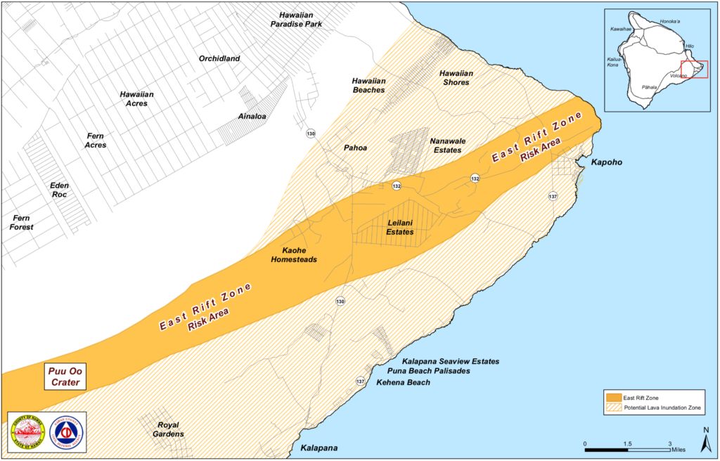
Eruption Risk Area Information, Civil Defense on High Alert
Hawai‘i County Civil Defense announces they are on high alert on a 24-hour basis for the possibility of a volcanic eruption in the lower Puna area. All areas bordering the East Rift Zone are at high risk for eruption activities. Hawaiian Volcano Observatory has identified magma movement in the lower East Rift Zone. Civil Defense urges all residents to keep themselves informed and on the alert.
All areas from Pu`u O`o crater down to Kapoho along the East Rift Zone are at risk. Please be aware that volcanic activities can take place with little or no warning.
Be on the alert for the following volcanic hazards:
- Lava inundation
- Fire
- Smoke
- Methane gas explosion
- Earthquakes
- Poor air quality
- Residents of high-risk areas are urged to take the following actions:
- Do prepare your emergency plan. Plans should be discussed with your family now.
- Stay informed on the situation by listening to your radio.
- You are asked to report any unusual events to Civil Defense at (808) 935-0031.
- If you need special assistance, please call (808) 935-0031.
- Evacuation shelters will be open as needed, and you will be informed about shelter locations.
Hawai‘i County Civil Defense is working in close coordination with Hawaiian Volcano Observatory. The entire County emergency response team has been activated.
You are asked to keep yourself informed, and be prepared for immediate evacuation if necessary.
For your further information, go to the following helpful links and contact numbers:
Updates Hawaiian Volcano Observatory Kilauea Activity Summary available here: https://volcanoes.usgs.gov/volcanoes/kilauea/status.html and by phone at (808) 967-8862. Subscribe to these messages: https://volcanoes.usgs.gov/vns2/
Recent Earthquakes in Hawai’i (map and list):
https://volcanoes.usgs.gov/hvo/earthquakes/
Lava viewing information:
Hawai‘i Volcanoes National Park: https://www.nps.gov/havo/planyourvisit/lava2.htm
County of Hawaii: http://www.hawaiicounty.gov/lava-viewing/
Kalapana lava-viewing area: 808-430-1966
Webcam images: https://volcanoes.usgs.gov/volcanoes/kilauea/multimedia_webcams.html
Photos/Video: https://volcanoes.usgs.gov/volcanoes/kilauea/multimedia_chronology.html
Lava Flow Maps: https://volcanoes.usgs.gov/volcanoes/kilauea/multimedia_maps.html
Definitions of terms used in update: https://volcanoes.usgs.gov/volcanoes/kilauea/extra/definitions.pdf
Overview of Kīlauea summit (Halemaʻumaʻu) and East Rift Zone (Puʻu ʻŌʻō ) eruptions:
https://volcanoes.usgs.gov/volcanoes/kilauea/extra/background.pdf
Summary of volcanic hazards from Kīlauea eruptions:
https://volcanoes.usgs.gov/volcanoes/kilauea/extra/hazards.pdf
Explanation of Volcano Alert Levels and Aviation Color Codes:
https://volcanoes.usgs.gov/activity/alertsystem/index.php
https://pubs.usgs.gov/fs/2006/3139/


