Drought Report: 90.65% of State Abnormally Dry or Drier

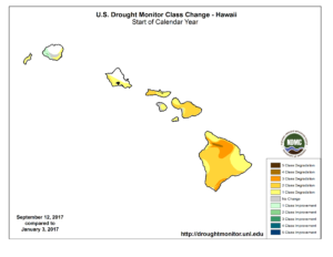
This map, released Thursday by the United States Drought Monitor, shows the levels of drought across the state. Photo credit: The National Drought Mitigation Center.
A recent report from the US Drought Monitor showed that 90.65% of the State was abnormally dry or drier than year-ago data. At this time in 2016, only 9.44% of the State had abnormally dry or drier conditions reported.
The map showed abnormally dry conditions for the majority of the South Hilo, Puna, North Kohala and North and South Kona districts.
Severe drought was recorded near the Pahala area as well as the Honoka‘a and Laupahoehoe areas.
Hawai‘i island was the only island to have extreme drought present. The two areas labeled as extreme drought were recorded in the Waimea and Na‘alehu areas.
Kaua‘i and O‘ahu were the only two islands that had no drought conditions present at some location on their island.
Data provided for the week ending on Sept. 12, showed that 9.35% of the State had no drought conditions reported, compared to 90.56% of the State having no drought conditions reported at the same time last year.
The map showed that the majority of the island of Maui was experiencing moderate drought conditions. Severe drought conditions were marked from Kīhei to Wailea-Mākena. The only area to have the lowest amount labeled as “abnormally dry” was from Kā’anapali to Wailuku, including Kapalua, Waiehu and Waihe’e.
The entire island of Lāna‘i reported “abnormally dry” conditions as did the east end of Moloka‘i. However, severe droughts were reported on the west end of Moloka‘i. The entire island of Kaho‘olawe reported moderate drought conditions.
The report said that on Hawaiʻi, deteriorating pastures and vegetation brought moderate drought conditions into southwest Kauaʻi while below-normal rainfall on 1- to 3-month time scales led to abnormal dryness development on the lower Kona slopes on the Big Island.
Finally, limited improvement to former severe dry and moderate dry conditions was noted on northeast parts of the Big Island.
The report said that for the week ending on Sept. 17, 2017, the state rainfall averaged 0.42 inches.
Hawai‘i County
The Waimea Irrigation Systems level at the Puukapu reservoir was marked at 48.00 feet (49.10 MG) as of Friday, Sept. 15, 2017, up 1.75 feet from the previous Friday reading. The Puu Pulehu reservoir was marked at 18.50 feet (106.75 MG) on Sept. 8, unchanged from the prior week. A mandatory 10% conservation remained in effect.
The Honokaia Reservoir was at 8.00 feet (1.00 MG) as of Sept. 15, same as the previous Friday reading.
The water level at the Paauilo reservoir was marked at 21.00 feet (10.00 MG) on Sept. 15, same as the previous Friday reading. The Paauilo and Honokaia Reservoirs feed into the Lower Hamakua Irrigation System where no conservation measures were in effect.
Maui County
The Molokaʻi Irrigation System water level was marked at 30.50 feet on Friday, Sept. 15, 2017, down 0.25 feet from the previous Friday reading. Conservation measures urged all non-homestead water users to cutback water consumption by 10%.
The Waikamoi reservoir #1 water level was marked at 0.80 MG on Friday, Sept. 15, 2017, unchanged from the previous Friday reading. The Waikamoi reservoir #2 water levels was marked at 2.90 MG on the same day, unchanged from the previous Friday reading. Each reservoir has a 15.00 MG capacity.
The Kahakapao reservoir #1 was marked at 41.70 MG on Friday, Sept. 15, 2017, down 0.20 MG from the previous Friday reading. The Kahakapao reservoir #2 water levels was marked at 41.50 MG on the same day, down 0.20 MG from the previous Friday reading. Each reservoir has a 50.00 MG capacity.
The Piiholo reservoir was recorded at 37.10 MG on Friday, Sept. 15, 2017, down 1.50 MG from the previous Friday reading. This reservoir has a capacity of 50.00 million gallons.
Honolulu County
The Waimanalo Irrigation System water level was marked at 51.00 feet (40.36 MG) as of Sept. 15, 2017, up 1.75 feet from the previous Friday reading. No conservation measures were in effect.
Complete information provided by the Drought Monitor can be found on their website.
Sponsored Content
Comments


_1770333123096.webp)


