

Trade Wind Swell to Generate Moderate Choppy Surf for East-Facing Shores
Alerts (as of 1 a.m.)
There are no marine alerts posted at this time.
Big Island Surf Forecast
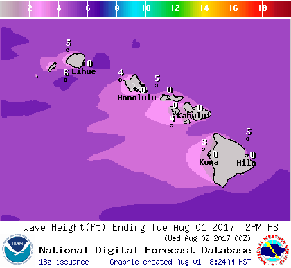
Wave height, Aug. 1, 2017. NOAA/NWS
Hilo side: Surf heights are expected to be knee/chest high today.
Kona side: Wave heights are expected to be ankle/thigh high today. Some spots will be flat.
South: Wave heights are expected to be ankle/thigh high today. Some spots will be flat.
Trade wind swell is forecast to keep moderate choppy surf along east-facing shores.
A series of small southerly swells will bring small background surf for most south-facing shores through the middle of the week. A small southwest is expected to fill in Tuesday into Wednesday before easing Thursday. On Aug. 5, a larger swell is expected.
Typhoon Noru has potential to bring us swell so we will keep an eye on the models over the next couple of days. A very small west-northwest pulse is possible for the weekend/early next week.
Keep in mind, surf heights are measured on the face of the wave from trough to crest. Heights vary from beach to beach, and at the same beach, from break to break.
Sponsored Content


