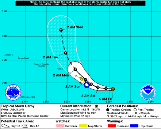
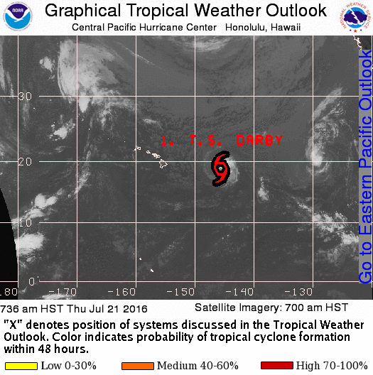
UPDATE: Tropical Storm Warning in Effect
Tropical Story Darby is maintaining its strength as it heads toward the Big Island.
UPDATE: July 22, 6 a.m.
This is a Tropical Storm Darby information update from Hawai‘i County Civil Defense for Friday, July 22, at 6:30 a.m.
The National Weather Service has issued a Tropical Storm Warning for Hawai‘i County. A tropical Storm Warning means that tropical storm conditions are expected in Hawai‘i County within 36 hours. A high surf warning for east facing shores is also in effect.
As of this morning, Tropical Storm Darby is located about 390 miles east of Hilo moving to the west at 12 miles per hour. Maximum sustained winds are 60 miles per hour with higher gusts.
Damaging surf, rain, and wind are expected to begin affecting the Big Island later today. Residents are urged to complete storm preparations before nightfall.
UPDATE: July 21, 6 p.m.
Updated mainly for new probabilities and storm information from 5 p.m. Central Pacific Hurricane Center advisory.
Tropical Storm Darby is forecast to approach the islands from the east-southeast over the next couple of days.
Tropical Storm Darby is located about 500 miles east of Hilo moving in a west direction at 13 mph with sustained winds of 65 mph.
For the next 48 hours, little change in the storm’s strength is expected.
The current Central Pacific Hurricane Center forecast brings Darby very close to Hawai‘i Island and Maui County Saturday and Sunday.
Depending on the exact track that Darby takes, strong damaging winds and heavy rainfall are possible this weekend as Darby makes its closest approach. Very high and possibly damaging surf is likely for east facing shores as well.
The chance for damaging tropical storm conditions at Hilo is 62%, 57% at Bradshaw Field, 42% at South Point and 51% at Kailua-Kona.
This represents an upward trend since the last forecast.
Tropical storm force winds over 39 mph may begin overspreading parts of Hawai‘i Island late Friday night or Saturday morning, and then reach Maui County later on Saturday.
Depending on the exact track of Darby, there is the possibility of significant wind damage, including downed trees and power lines, and damage to roofs and weak structures.
A high surf warning is in effect for east facing shores of Hawai‘i Island and Maui starting Friday. Surf is expected to build to 12 to 20 feet on Friday with occasional higher sets. This may cause significant wave run-up or damage on some windward coastal roads.
A flash flood watch is in effect. Showers will increase over the windward side of Hawai‘i Island tonight and Friday, followed by heavy rain and squalls with embedded thunderstorms starting Friday night.
This may result in road closures, damage to roads, and rockslides or landslides. The heavy rain threat will then spread to Maui County on Saturday.
CLOSURES
All camping reservations at county parks are being cancelled from Friday to Sunday. Pavilion reservations at county parks are also being cancelled on Saturday and Sunday, and county swimming pools will also be closed along with the Ho‘olulu Complex.
Lava viewing in Kalapana will be closed from Friday to Sunday.
EMERGENCY SHELTERS TO OPEN FRIDAY
The following public schools are scheduled to be opened as emergency shelters at 4 p.m. Friday, July 22. Consider bringing bedding, food, water and any personal items you may need.
- Hilo High
- Waiakea High
- Kalanianaole Elementary
- Kea‘au High
- Pahoa High
- Laupahoehoe Community Charter School
- Honoka‘a High and Intermediate
- Kohala High and Elementary
- Waikoloa Elementary
- Kealakehe High
- Konawaena High
- Ka‘u High
- Mountain View Elementary
PRECAUTIONS
It is vital that Hawai‘i residents do not focus on the exact forecast track. Forecast movement, direction and speed are only estimates. Even small errors in the forecast track can mean major differences in where the worst conditions will occur. Also, remember that damaging effects can extend far from the center.
For those under a watch, now is the time to prepare. Secure or bring indoors any loose outdoor objects—lawn furniture, childrens toys, hanging plants, barbecue grills, or any item that could become a destructive projectile in strong winds. Do not wait until it is too late.
Stay calm and keep informed. Closely monitor NOAA weather radio or BigIslandNow.com for official updates.
Be ready to evacuate if necessary. Heed the advice of local officials and comply with any orders that are issued. Persons living near the shore should be prepared to evacuate quickly should building surf threaten.
Loose objects such as lawn furniture, garbage cans, and other items should be secured or stored indoors. Have supplies on hand and be ready for power outages.
Evacuate if ordered by local officials.
Stay away from any beaches which have been closed.
UPDATE: July 21, 1:40 p.m.
The Central Pacific Hurricane Center in Honolulu is issuing advisories on Tropical Storm Darby, located about 550 east of Hilo and 740 miles east-southeast of Honolulu.
UPDATE: TROPICAL STORM WATCH ISSUED
July 21, 11:07 a.m.
Tropical Storm Darby is edging closer to Hawai‘i with little change in strength.
A tropical storm watch has now been issued for Hawai‘i Island, including the north and east areas, the interior and summits of the island.
The watch is in also in effect for Maui, Moloka‘i. Lanai and Kaho‘olawe.
A tropical storm watch means that tropical storm conditions are possible within the next 48 hours somewhere within the specified areas.
A flash flood watch is still in effect.
A high surf warning is in effect for east-facing shores of Hawai‘i Island and Maui from 6 a.m. Friday until 6 a.m. Sunday.
At 11 a.m. HST today, center of Tropical Storm Darby was located near latitude 18.6N and longitude 146.6W—about 560 miles east of Hilo and about 755 miles east-southeast of Honolulu.
Tropical Storm Darby is moving west at 14 mph.
Maximum sustained winds are near 65 mph.
Forecast movement, direction and speed are only estimates. Even small shifts in the track can mean major differences in where the worst conditions will occur. Damaging effects can extend far from the center.
A watch is typically issued 48 hours before the possible arrival of tropical storm force winds that make continuing outside preparations dangerous. A watch is the time for you to prepare.
A warning is typically issued 36 hours before the expected arrival of tropical storm force winds. A warning is the time or you to finish your preparations and begin moving to safe shelter.
The next local statement will be issued around 12:30 p.m. HST or sooner if conditions warrant.
ORIGINAL POST: July 21, 11:13 a.m.
The National Weather Service in Honolulu has issued a flood watch for Hawa‘i Island.
Approaching Tropical Storm Darby could bring excessive rainfall with potential for significant flash flooding.
A flash flood watch is in effect from late Friday night through Sunday afternoon for Hawai‘i Island and Maui. A flash flood watch means that conditions may develop that lead to flash flooding.
Tropical Storm Darby is expected to continue to approach the state. Depending on the exact track, there is the possibility of intense rainfall and flash flooding this weekend.
The greatest risk of flash flooding will be to east and southeast facing slopes.
In addition to flood-prone areas, heavy rain events of this size may cause flooding in areas outside designated flood zones.
Low spots in roads can become dangerous and impassable due to severe runoff.
High amounts of debris in streams and gulches may clog bridges and culverts resulting in dangerous
flooding, which could occur outside the normal channels and could also lead to significant property damage.
Flash flooding is very dangerous. Never drive into areas where water covers
the road. Turn around, don’t drown.
Sponsored Content
Comments


