

UPDATE: Hurricane Ignacio Likely Peaks
***Updated at 11 p.m. to include information from the Central Pacific Hurricane Center and the National Hurricane Center.***
By: Jamilia Epping
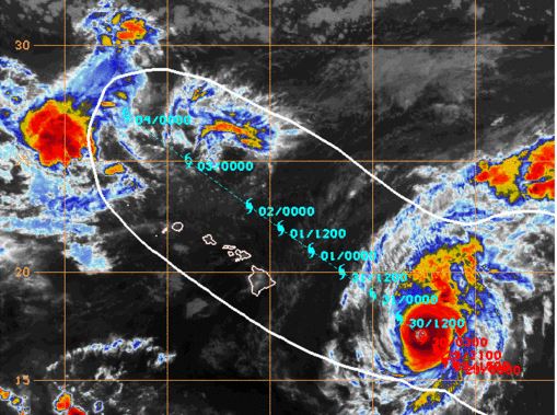
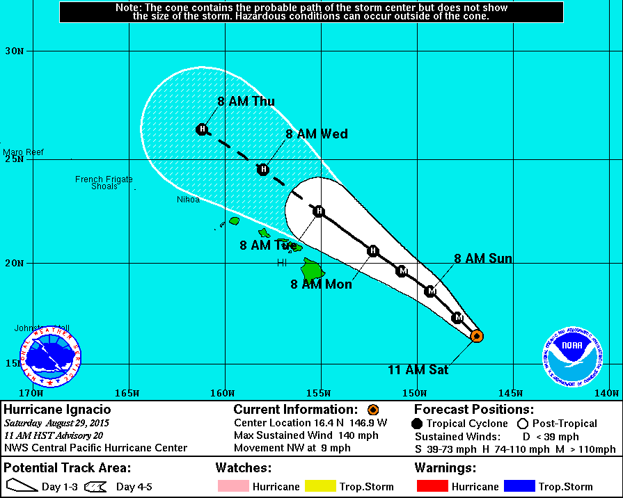
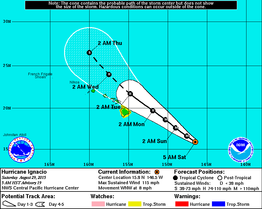
Hurricane Ignacio was about 495 miles east-southeast of Hilo, as of the Central Pacific Hurricane Center’s 11 p.m. advisory. The storm was maintaining its strength with continued maximum sustained winds of 140 miles per hour, keeping it a Category 4 hurricane.
CPHC reports that Hurricane Ignacio was moving to the northwest at a rate of 8 mph.
Tropical storm wind conditions are still forecast to be felt on the Big Island beginning late Sunday night.
Forecasters predict that rainfall amounts could vary between two to four inches, with up to six inches of rain in upslope areas.
Large swells are expected to arrive over southeast and eastern shores in the next several days. A High Surf Warning remains in effect for north, south, and east facing shores of the Big Island through 6 p.m. Tuesday.
Satellite imagery shows that shear may be beginning to affect the system and that the storm has likely reached its peak.
CPHC notes that despite forecasted weakening, Hurricane Ignacio will pass close enough to the state that a Tropical Storm Watch will remain in effect for the Big Island, along with Maui County.
National Hurricane Center image, as of 11 p.m.
Hurricane Jimena remains a Category 4 storm. As of 11 p.m. Jimena was located 1,573 miles from Hilo with maximum sustained winds of 130 mph, a 10 mph decrease since 5 p.m.
The National Hurricane Center says Jimena was moving to the west-northwest at 13 mph, a general motion that is expected over the next couple of days.
Jimena is expected to maintain major hurricane strength through Monday.
***Updated at 8:10 p.m. to include information from the Central Pacific Hurricane Center.***
By: Jamilia Epping
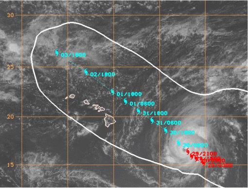
Central Pacific Hurricane Center image, as of 5 p.m.
As of 8 p.m., Hurricane Ignacio was about 515 miles east-southeast of Hilo.
Maximum sustained winds increased to 145 miles per hour. The storm is still classified as a Category 4 hurricane.
Hurricane Ignacio is currently moving northwest at 9 mph.
***Updated at 5:30 p.m. to include information from the Central Pacific Hurricane Center and the National Hurricane Center’s 5 p.m. updates.***
By: Jamilia Epping
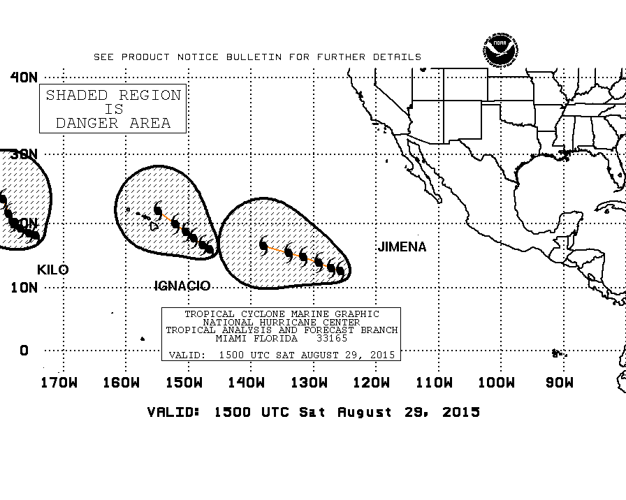
The Central Pacific Hurricane Center’s 5 p.m. update showed that Hurricane Ignacio was 525 miles east-southeast of Hilo. Its maximum sustained winds have increased slightly since 2 p.m. to 140 miles per hour.
Hurricane Ignacio is moving to the northwest at 9 mph.
A Tropical Storm Watch remains in effect for the Big Island.
Maui County is also under the Tropical Storm Watch.
A Tropical Storm Warning has also been issued, only for the waters off the Big Island to the east and southeast.
CPHC says tropical storm force winds could impact the Big Island as early as Sunday night.
Large swells also bring the potential for dangerous surf for East and South facing shores.
CPHC analysis shows that southwesterly wind shear is beginning to have an effect on Hurricane Ignacio. The shear is expected to increase as the storm nears the islands, beginning a general weakening trend that is expected to start on Sunday.
As of 5 p.m., Hurricane Jimena was located 1,631 miles from Hilo. The National Hurricane Center has maintained watch over the storm that has picked up in speed, moving 13 mph toward the west-northwest.
Maximum sustained wind speeds remain at 140 mph.
***Updated at 2:15 p.m. to include Central Pacific Hurricane Center information.***
By: Jamilia Epping
Central Pacific Hurricane satellite image, as of 11 a.m.
At 2 p.m., Hurricane Ignacio was located 550 miles east-southeast of Hilo. The storm’s maximum sustained winds dropped to 135 miles per hour since 11 a.m.
According to the Central Pacific Hurricane Center, Hurricane Ignacio is moving to the northwest at 9 mph. The storm is still expected to pass northeast of the Big Island on Monday.
***Updated at 11:10 a.m. to include information from the Central Pacific Hurricane Center and the National Hurricane Center’s 11 a.m. advisories.***
By: Jamilia Epping
As of the Central Pacific Hurricane Center’s 11 a.m. update, Hurricane Ignacio was 585 miles east-southeast of Hilo, moving at a pace one mile faster than earlier in the morning at 9 miles per hour.
Central Pacific Hurricane Center image, as of 11 a.m.
A major highlight of the 11 a.m. advisory is the increase in maximum sustained winds, making Hurricane Ignacio a Category 4 hurricane. Ignacio is currently holding wind speeds of 140 mph, an increase of 25 mph since 8 a.m.
CPHC reports that additional strengthening is expected Saturday before the storm sets on a weakening trend.
Hurricane Ignacio has shifted slightly, now traveling in a northwest direction. The latest track continues to show the storm passing north of the island chain.
A Tropical Storm Watch remains in effect for the Big Island.
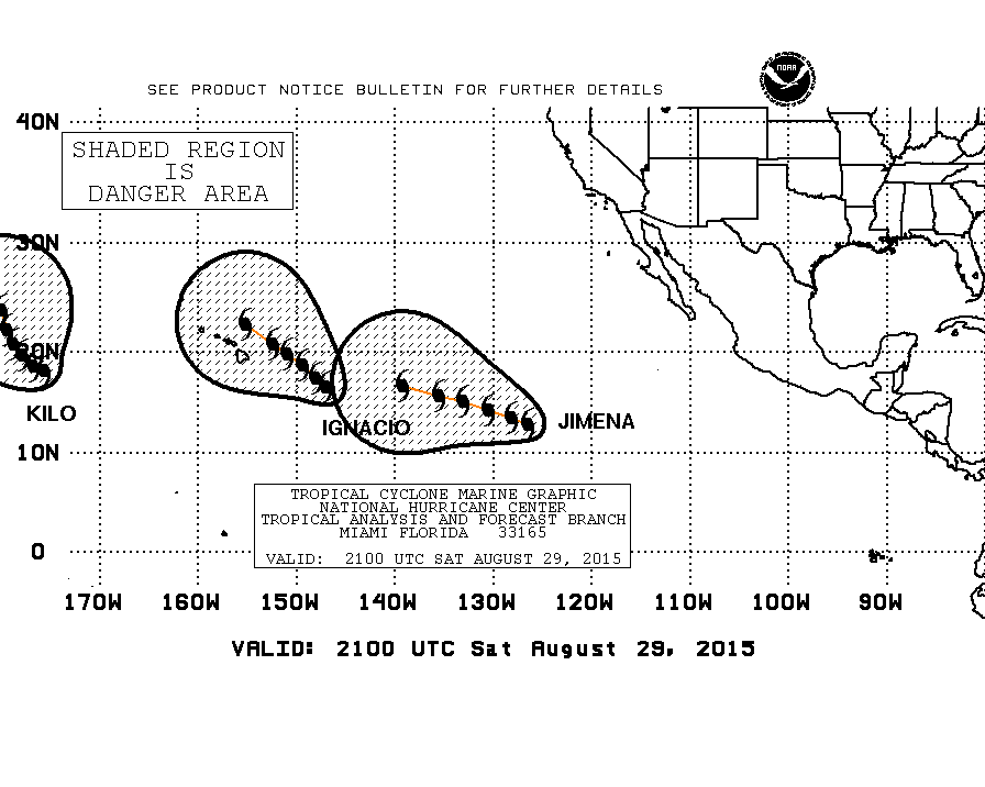
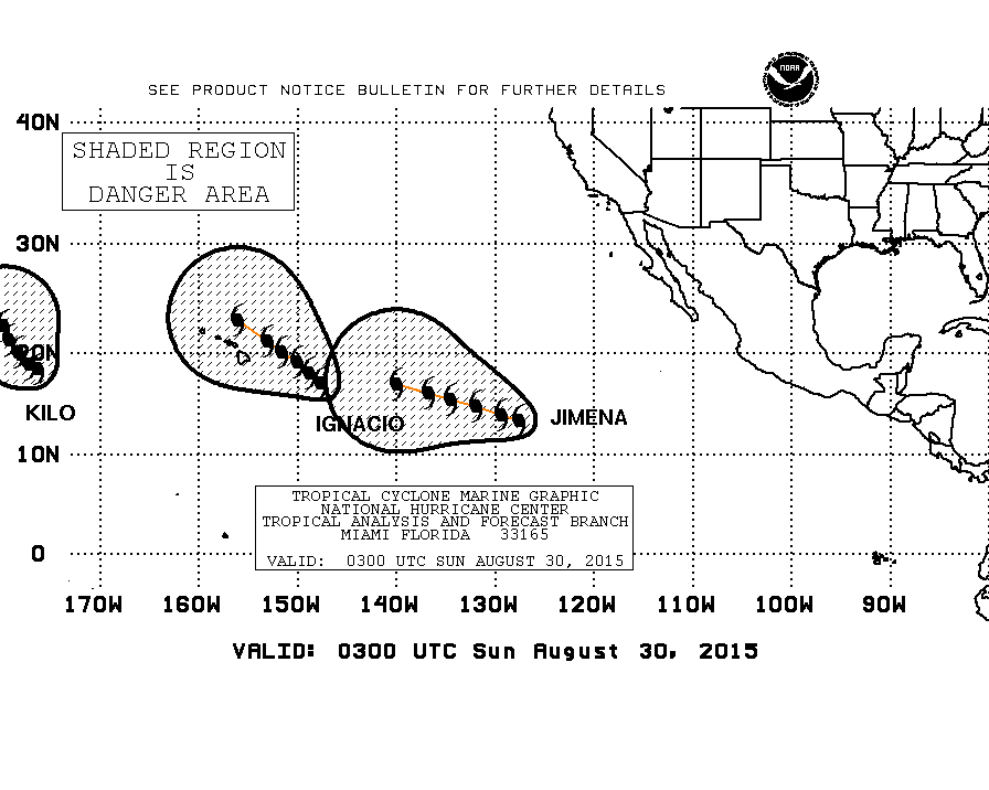
National Hurricane Center image, as of 11 a.m.
Meanwhile in the Eastern Pacific, Hurricane Jimena, being tracked by the National Hurricane Center, has turned west-northwest and is expect to continue in this direction as it increases in forward speed through Monday.
Hurricane Jimena was about 1,701 miles from Hilo, as of 11 a.m, and has maintained Category 4 hurricane strength at 140 mph, which is expected to continue through Monday.
***Original story posted at 8:25 a.m.***
By: Jamilia Epping
Hurricane Ignacio continued to strengthen throughout the night and has reached Category 3 hurricane status, as of 5 a.m. As a result of Ignacio’s current path and strength, the Big Island has been placed under a Tropical Storm Watch.
The Central Pacific Hurricane Center says that as of 8 a.m., Ignacio was about 525 miles east-southeast of Hilo, traveling at a speed of about 8 miles per hour in a west-northwest direction.
Central Pacific Hurricane Center image, as of 5 a.m.
Maximum sustained winds held by Hurricane Ignacio have increased to 115 mph with some higher gusts. The storm is expected to continune to strenthen throughout Saturday, with an expected gradual weakening Sunday and Monday. Outer winds of Ignacio have the potential to affect the Big Island by early Monday morning.
Hurricane Ignacio is currently in an area with very weak shear, providing environmental conditions that encourage the strengthening of the storm. Warm water temperatures and continued light shear are on the storm’s immediate track. By Sunday, however, southwest shear is forecast to gradually increase.
Hurricane Hunters will conduct a reconnaissance flight Saturday morning. The flights will be flown every 12 hours through Sunday morning, when they will increase to every six hours.
A Tropical Storm Watch means that tropical storm conditions are possible within the next 48 hours. CPHC says that although Hurricane Ignacio is currently tracking north of the island chain, the Big Island is within the storm’s cone of uncertainty, making the watch necessary.
National Hurricane Center image, as of 5 a.m.
The National Hurricane Center contiues to issue notices for Hurricane Jimena. As of 5 a.m., Jimena was about 1,751 miles from Hilo, moving in a west direction at 8 mph. The storm is expected to take a west-northwest motion later in the day Saturday and continue through Monday.
Hurricane Jimena is currently classified as a Category 4 hurricane with maximum sustained winds near 150 mph.
NHC says that Hurricane Jimena may see fluctuations in intensity, but is expected to maintain major hurricane status through Monday.
Sponsored Content


