

11 p.m. HILDA UPDATE: Heavy Rainfall, Flooding Possible
***Updated at 11:10 p.m. to include information from the 11 p.m. Central Pacific Hurricane Center advisory. ***
Hurricane Hilda is maintaining its strength at 90 miles per hour, as of the Central Pacific Hurricane Center’s 11 p.m. advisory.
CPHC says Hilda was located 330 miles east-southeast of Hilo and has slowed down, moving to the northwest at 5 mph.
Forecasts predict that the storm will experience a slight pickup in speed Wednesday night as the storm turns towards the west-northwest. In the meantime, steady weakening is expected Tuesday and Hurricane Hilda is forecast to become a tropical storm by Tuesday night.
No watches or warnings are currently in effect, however, a tropical storm watch could be posted as early as Tuesday.
***Updated at 5 p.m. to include information from the 5 p.m. Central Pacific Hurricane Center advisory.***
As of the 5:00 p.m. Central Pacific Hurricane Center update, Hilda still has maximum sustained winds at 90 mph and is a strong Category 1 hurricane. The system is still expected to weaken to a tropical storm sometime tomorrow.
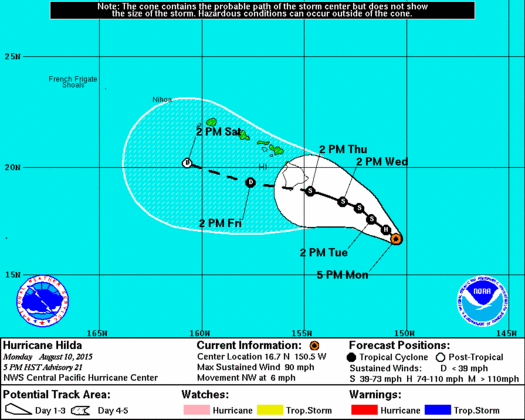
CPCH 5 p.m. update August 10, 2015
The storm is moving NW near 6 mph and this general motion is expected to continue for the next couple of days.
Hurricane force winds extend 25 miles from the center and tropical storm force winds extend up to 90 miles from the center.
Although Hilda is a compact tropical cyclone, the low level moisture field surrounding the system is pretty broad. This means islands to the east of the track could see an increase in shower activity even if Hilda is several hundred miles away.
In fact, Hilda is now expected to produce heavy rain over portions of the state Thursday and Friday. This type of rainfall could cause flash flooding, mudslide and rockslide conditions. The National Weather Service warns that regardless of the system’s strength, the potential for very heavy rainfall exists for the entire state. Details on timing, location and amount of rainfall are highly dependent on the eventual track Hilda takes.
Other effects include a large swell which is expected to continue for east shores over the next couple of days. A High Surf Advisory remains posted for the east exposures of the Big Island and Maui.
A Hurricane Warning has been issued for Hawaiian offshore waters from 40 nautical miles to 240 nautical miles for high seas and high winds.
Hurricane Hunters will again fly into Hilda this evening to collect important data on the storm.
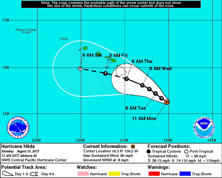
Central Pacific Hurricane Center image, as of 11 a.m.
***Updated at 11:05 a.m. to inlcude information from the 11 a.m. Central Pacific Hurricane Center advisory.***
As of the Central Pacific Hurricane Center’s 11 a.m. update, Hurricane Hilda was about 400 miles southeast of Hilo with a track that is continuing west-northwest towards the Big Island.
Maximum sustained winds remain at 90 miles per hour as Hurricane Hilda continues to push in a west-northwest direction at about eight mph.
Forecasts continue to predict that Hurricane Hilda, currently a Category 1 hurricane, will continue to weaken over the next 48 hours. It’s expected that by Tuesday, Hilda will downgrade to a tropical storm.
CPHC reports that hurricane force winds are extending outward up to 25 miles from the center of the storm, and tropical storm force winds are extending up to 90 miles from the center.
***Original story posted at 7:25 a.m.***
Hurricane Hilda will continue to weaken over the next 48 hours, according to forecasts from the Central Pacific Hurricane Center.
As of CPHC’s 5 a.m. advisory, Hurricane Hilda was located 425 miles southeast of Hilo, moving at a speed of 9 miles per hour in a northwest direction. Maximum sustained winds were at about 90 mph with higher gusts.
Forecasts predict that the storm will steadily weaken over the next couple of days and downgrade to tropical storm status by Tuesday.
A flight by the United States 53rd Weather Reconnaissance Squadron is scheduled for Monday morning to gather data important to storm tracking.
Current forecasts predict that Hurricane Hilda may pass well south of the Big Island, despite the current model showing the storm pass over the southern portion of the Big Island. Forecasters say the differing forecasts could be based on differences in the depth of the forecast. Exact impacts to the Big Island are not immediate clear, according to CPHC officials.
Hurricane Hilda, like predecessor Guillermo, is expected to impact surf on the Big Island. Large and potentially life threatening swells along both the east and southeast facing shores is expected to make an impact over the next couple of days.
Sponsored Content


