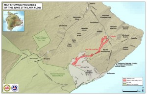
June 27 Lava Flow Update – 3/27/15
During Hawai’i County Civil Defense’s Friday overflight assessment of the June 27 lava flow, activity continued to be observed in the upslope area near the summit of Pu’u O’o, beginning about 8 miles up from the area of the stalled flow fronts.
The lava flow and breakouts nearest Pahoa continue to remain quiet.
Smoke conditions were light Friday morning as vegetation continued to burn along the edges of the breakouts and a northeast wind was blowing the smoke in a southwest direction.
Beginning Saturday, Civil Defense will discontinue their daily assessments and eruption updates. Hawaiian Volcano Observatory downgraded the lava flow alert level from a Warning to a Watch on Wednesday following inactivity in the downslope regions of the flow.
Despite the suspension of daily updates from Civil Defense, the agency, along with HVO, will continue to monitor the flow, keep the public informed of any changes occurring, and give sufficient warning should a possible threat arise.
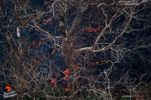
This photo, taken March 26, shows the barren, sunlight bleached branches of ohia trees, contrasting starkly with oranges and blacks of the active flow beneath. Photo credit: Extreme Exposure Media/Paradise Helicopters.
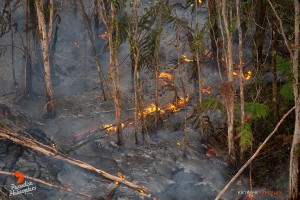
In this photo, taken March 26, a finger of lava flows through an ohia forest, consuming the understory of hapu‘u ferns. Photo credit: Extreme Exposure Media/Paradise Helicopters.

This photo, taken March 26, shows a fresh breakout in the middle of the flow field. Photo credit: Extreme Exposure Media/Paradise Helicopters.

In this photo, taken March 27, a toe of lava oozes out from beneath the hardened crust. Photo credit: Extreme Exposure Media/Paradise Helicopters.
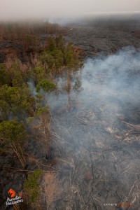
This image, taken March 26, shows the low cloud cover, and two areas where trees were being consumed in the flow field. Photo credit: Extreme Exposure Media/Paradise Helicopters.


