

Iselle Update: 9 a.m. Press Conference Highlights
Forecasters with the Central Pacific Hurricane Center say they still expect Iselle to make landfall on the Big Island of Hawaiʻi later today as a hurricane.
The impacts — in the form of heavy rain, strong winds, and storm surge — are anticipated to begin as early as 4 p.m. on Hawaiʻi Island today, with the center of the storm passing over the Big Island of Hawaiʻi in the late afternoon to evening hours.
The northern edge of the system will carry the strongest winds at 60 to 70 mph, and 85 mph gusts on Hawaii Island, according to Mike Cantin, meteorologist in charge with the National Weather Service Forecast Office in Tucson, AZ.
According to Cantin, the terrain on Hawaii Island is expected to zap some of the strength of the system as it approaches Maui later tonight and into tomorrow.
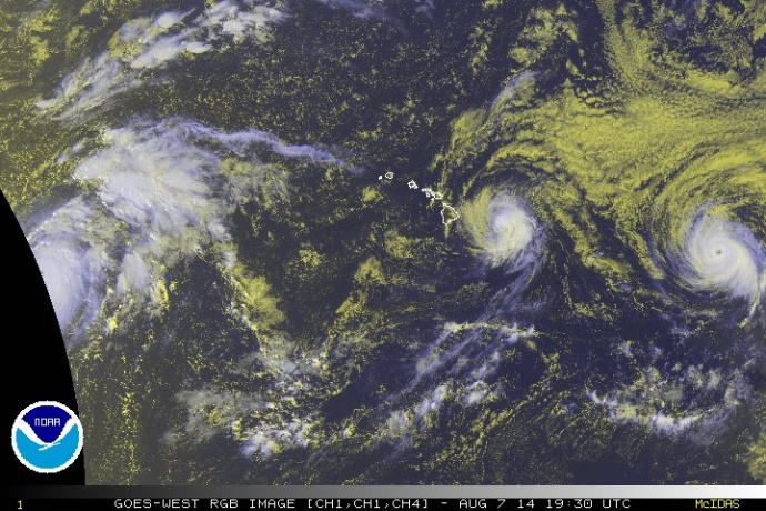
Satellite imagery of Iselle at 9:30 a.m. HST, Thursday, Aug. 7, 2014. Image courtesy CPHC/NOAA/NWS.
Winds will be 45 to 55 mph on Maui with 65 mph gusts. Rain will be 5 to 8 inches, and as much as 12 inches in isolated locations. Dangerous surf will be 15-25 along the E and NE sides of the Big Island of Hawaiʻi, and 12-18 feet elsewhere in the state, mainly for E & NE sides.
According to Cantin, the terrain of the Big Island will act to grab the bottom portion of the storm and hold it back while the top continues to move — this will separate the system and weaken it dramatically. Rain will remain focused over the windward areas with prolonged periods of heavy rainfall, he said.
At 8 a.m., Iselle was located: 245 miles ESE of Hilo; 310 miles ESE of Kailua-Kona; 280 miles E of South Point; 360 miles ESE of Kahului; 415 miles ESE of Kaunakakai; 390 miles ESE of Lānaʻi City; 460 miles ESE of Honolulu; 560 miles ESE of Līhue; and 610 miles ESE of Niʻihau, according to the CPHC.
The following is the mid-morning forecast update issued by the Central Pacific Hurricane Center for Maui County:
..TROPICAL STORM WARNING REMAINS IN EFFECT…
..PRECAUTIONARY/PREPAREDNESS ACTIONS…
PRECAUTIONARY/PREPAREDNESS ACTIONS…
LOOSE OBJECTS SUCH AS LAWN FURNITURE…GARBAGE CANS…AND OTHER
ITEMS SHOULD BE SECURED OR STORED INDOORS. HAVE SUPPLIES ON HAND
AND BE READY FOR POWER OUTAGES. EVACUATE IF ORDERED BY LOCAL
OFFICIALS.
TROPICAL STORMS CAN BRING VERY HEAVY RAIN LEADING TO FLASH
FLOODING. PEOPLE NEAR STREAMS…RIVERS…AND LOW-LYING FLOOD
PRONE AREAS ARE URGED TO BE ESPECIALLY ALERT TO FLASH FLOODING.
..WINDS…
BASED ON THE LATEST FORECAST TRACK…WINDS OVER 40 MPH ARE
EXPECTED TO BEGIN OVERSPREADING THE AREA TONIGHT AND CONTINUE
THROUGH LATE FRIDAY MORNING. IN SOME AREAS…WINDS WILL BE AS
HIGH AS 45 TO 55 MPH WITH GUSTS TO 65 MPH.
GUSTS WILL BE STRONGEST OVER MOUNTAINOUS TERRAIN…THROUGH
PASSES…AND WHERE WINDS BLOW DOWNSLOPE. WINDS AFFECTING THE
UPPER FLOORS OF HIGH RISE BUILDINGS WILL BE SIGNIFICANTLY
STRONGER THAN THOSE NEAR GROUND LEVEL.
HOMES MAY HAVE DAMAGE TO SHINGLES…SIDING…GUTTERS AND
WINDOWS…ESPECIALLY IF THESE ITEMS ARE NOT PROPERLY SECURED.
LOOSE OUTDOOR ITEMS WILL BECOME AIRBORNE…CAUSING ADDITIONAL
DAMAGE AND POSSIBLE INJURY.
SOME POWER LINES WILL BE KNOCKED DOWN BY FALLING TREES…
RESULTING IN SCATTERED POWER OUTAGES. MANY LARGE BRANCHES OF
TREES WILL BE SNAPPED…AND A FEW TREES WILL BE UPROOTED.
..STORM SURGE AND STORM TIDE…
SURF WILL STEADILY INCREASE TO HAZARDOUS LEVELS OF 18 FEET ALONG
THE EXPOSED WINDWARD COASTS TODAY…AND REACH HAZARDOUS LEVELS
LATER TODAY. SOME SOUTH FACING SHORES WILL SEE SURF NEAR 10 FEET
ON FRIDAY. THE ASTRONOMICAL HIGH TIDE FOR HANA TODAY IS 142 PM AT
2.7 FEET AND FRIDAY IS 218 PM AT 2.9 FEET. THE HIGH SURF AND HIGH
TIDE COMBINATION WILL BRING THE POTENTIAL FOR COASTAL FLOODING
ALONG LOW LYING AREAS.
..INLAND FLOODING…
A FLASH FLOOD WATCH IS IN EFFECT FOR THE ENTIRE AREA. HEAVY
RAINFALL OF AROUND 5 TO 8 INCHES IS EXPECTED WITH ISOLATED
RAINFALL TOTALS OF 12 INCHES. THESE HEAVY RAINS COULD LEAD TO
LIFE THREATENING FLASH FLOODS.
As of this morning, the Hawaii Tourism Authority was advised that American Airlines, Island Air, Mokulele, United Airlines and US Airways have made flight cancellations. The agency is encouraging anyone traveling through the weekend to contact their airline carriers directly to confirm their flights and make any changes.
***See a full list of closures and cancellations for Hawai’i County here.
Sponsored Content


