

UPDATE: Tremor Likely Caused by Settling, Scientists Say
***Updated at 4:59 p.m.***
Today’s 5.3-magnitude earthquake likely was related to the settling of the Big Island, scientists at the Hawaiian Volcano Observatory said in a statement issued this afternoon.
Wes Thelen, HVO’s seismic network manager, said the earthquake was located 12 miles east of Loihi, but geologists do not believe it was associated with the submarine volcano.
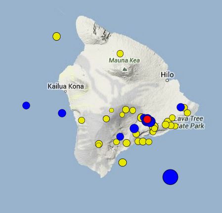
This map from HVO shows recent earthquakes in the area of the Big Island. Bigger circles indicate stronger quakes. Yellow ones occurred up to two weeks ago, blue ones within the past two days and the red one, which had a magnitude of 2.0, happened at 3:49 p.m. today.
“The earthquake was most likely a structural adjustment of the Earth’s crust due to the weight of Hawaii Island on the underlying mantle,” he said.
Seismic records maintained by the Big Island facility show another earthquake of similar magnitude and depth in this same general area in 2005, the statement said.
According to HVO, today’s earthquake was felt as far away as Oahu.
***Updated at 3:40 p.m.***
Civil Defense officials said the earthquake that struck this afternoon was wide-felt but caused no damage.
“We haven’t had any reports of damage,” said Civil Defense Administrator Darryl Oliveira.
He said according to initial reports, the tremor was felt across the island.
The shaking was also felt in Kahului and Lahaina on Maui, Maui Now reported.
Scientists with the US Geological Survey this afternoon pegged the earthquake as having a magnitude of 5.3.
It had initially been labelled as a magnitude 5.2 and then a 5.6 tremor.
Oliveira said a tsunami was not generated by the quake that struck 33 miles southeast of Pahala at a depth of 25 miles.
Flooding reported at the old Kona airport park in Kailua-Kona was the result of a strong south swell, he said.
That flooding, which reached as far inland as the runway, prompted the closing of the park, Oliveira said.
Posted at 2:33 p.m.:
The Big Island was jolted this afternoon by a strong earthquake that struck in the deep ocean 33 miles southeast of Pahala.
The US Geological Survey initially gave the earthquake a magnitude of 5.2 but later upgraded it to 5.6 magnitude
The Pacific Tsunami Warning Center said no tsunami was expected from the tremor that struck at 2:13 p.m.
Its epicenter was about a dozen miles east of the Loihi Seamount, the active volcano being built on the seafloor off the Ka`u coast.
The earthquake was apparently the strongest to strike the Big Island since the March 24, 2012 quake that struck near Honomu with a magnitude of 4.9.
Scientists attributed that earthquake to the settling of the island on the earth’s crust.
Sponsored Content


