

‘Dual-Pol’ Radar Upgrades Improving Weather Forecasts
The National Weather Service is getting a better look at weather conditions across the state, and particularly the Big Island.
The agency is upgrading all four of the Doppler weather units in Hawaii – two of which are located on the Big Island — to utilize a new technology known as dual polarization.
Two of the units, one located on Kauai and the other in North Kohala on the Big Island, were upgraded in May and June, respectively.
The weather service will be adding the technology to its unit in the Big Island’s Ka`u District late this month, and to the one on Molokai in mid-February.
The upgrades are part of a $50 million program involving weather service radar across the nation.
Conventional Doppler radar sends out a horizontal pulse, while the “dual pol” technology, as it is known, produces a two-dimensional image.
While one of the primary advantages of the dual pol Doppler is allowing forecasters to tell the difference between rain and snow or hail, it also has significant benefits for Hawaii.
For example, it allows meteorologists to identify updrafts which helps them determine the strength of rain systems as well as improve detection of cloud rotation, said Tom Evans, a spokesman for the National Oceanic and Atmospheric Administration, the federal agency in charge of the weather service.
It also helps forecasters more accurately estimate the amount of rain reaching the ground, which provides them with more timely and precise flood and flash-flood warnings.
Radar imagery from the Molokai and Ka`u units will not be available during the upgrades which are expected to be completed by Feb. 22.
The cost of each upgrade is about $225,000, Evans said.
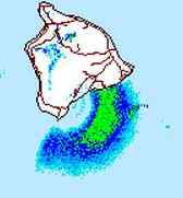
The “ground clutter” radar image caused by sea spray is shown at lower right. NWS image.
NOAA officials say another benefit of the technology is the improved detection of “ground clutter,” which is non-weather-related signals.
However, officials said it will not have an impact on one of the more prominent sources of radar ground clutter in the state, the sea spray that appears as a half-moon shape off the southern portion of the Big Island’s windward side.
Sponsored Content


